List of cities and counties of Gyeonggi Province

Last updated

Gyeonggi Province (Gyeonggi-do) is divided into 28 cities (si) and 3 counties (gun). Listed below is each entity's name in English, hangul and hanja.

Contents

Cities

  • Suwon (수원시;水原市, capital)
  • Ansan (안산시;安山市)
  • Anseong (안성시;安城市)
  • Anyang (안양시;安養市)
  • Bucheon (부천시;富川市)
  • Dongducheon (동두천시;東豆川市)
  • Gimpo (김포시;金浦市)
  • Goyang (고양시;高陽市)
  • Gunpo (군포시;軍浦市)
  • Guri (구리시;九里市)

Counties

List by Population and Area

NamePopulationArea (km²)Population Density (/km²)
Ansan 742,788144.785,130.5
Anseong 167,511553.46302.7
Anyang 622,37958.5210,635.3
Bucheon 868,51753.4416,252.2
Dongducheon 93,71895.66979.7
Gimpo 232,364276.64840.0
Goyang 938,784267.313,512.0
Gunpo 278,79036.387,663.2
Guri 211,72033.35,836.1
Gwacheon 72,08835.812,013.1
Gwangju 242,559430.69563.2
Gwangmyeong 334,52638.58,687.0
Hanam 139,41493.071,497.9
Hwaseong 497,907844590.0
Icheon 196,230461.20425.5
Namyangju 551,395458.441,202.8
Osan 166,80942.763,905.1
Paju 341,203672.42507.4
Pocheon 159,490826.38193.0
Pyeongtaek 406,191452.18898.3
Seongnam 970,847141.826,845.6
Siheung 417,037166.62,503.2
Suwon 1,095,957121.099,050.8
Uijeongbu 430,76981.595,279.7
Uiwang 135,05853.952,503.4
Yangju 179,923310.34579.8
Yeoju 107,121607.79176.2
Yongin 923,937591.321,562.5
Gapyeong County 56,815843.4667.3
Yangpyeong County 92,529877.08105.5
Yeoncheon County 45,572695.6165.5

General information

MunicipalSubdivisionsPoints of InterestImageLocationDescription
Ansan
  • Danwon-gu
    • Wa-dong
    • Gojan-dong
    • Hosu-dong
    • Wongok-dong
    • Choji-dong
    • Seonbu-dong
    • Daebu-dong
  • Sangnok-gu
    • Il-dong
    • I-dong
    • Sa-dong
    • Bono-dong
    • Bugok-dong
    • Wolpi-dong
    • Seongpo-dong
    • Banwol-dong
    • Ansan-dong
Map Ansan-si.png
Anseong
  • Anseong-dong
  • Gongdo-eup
  • Bogae-myeon
  • Geumgwang-myeon
  • Seoun-myeon
  • Miyang-myeon
  • Daedeok-myeon
  • Yangseong-myeon
  • Wongok-myeon
  • Iljuk-myeon
  • Juksan-myeon
  • Samjuk-myeon
  • Gosam-myeon
Map Anseong-si.png
Anyang
  • Dongan-gu
    • Bisan-dong
    • Buheung-dong
    • Dalan-dong
    • Gwanyang-dong
    • Burim-dong
    • Pyeongchon-dong
    • Pyeongan-dong
    • Gwiin-dong
    • Hogye-dong
    • Beomgye-dong
    • Sinchon-dong
    • Galsan-dong
  • Manan-gu
    • Anyang-dong
    • Seoksu-dong
    • Bakdal-dong
Anyang skyline.jpg Map Anyang-si.png
Bucheon
  • Sosa-gu
    • Simgokbon-dong
    • Sosabon-dong
    • Beombak-dong
    • Gyesu-dong
    • Okgildong
    • Goeandong
    • Songnae-dong
  • Wonmi-gu
    • Simgok-dong
    • Wonmi-dong
    • Sosa-dong
    • Yeokgok-dong
    • Chunui-dong
    • Dodang-dong
    • Yakdae-dong
    • Jung-dong
    • Sang-dong
  • Ojeong-gu
    • Seonggok-dong
    • Wonjong-dong
    • Gogang-dong
    • Ojeong-dong
    • Sinheung-dong
Map Bucheon-si.png
Dongducheon
  • Saengyeon-dong
  • Jungang-dong
  • Bosan-dong
  • Bulhyeon-dong
  • Songnae-dong
  • Soyo-dong
  • Sangpae-dong
Map Dongducheon-si.png
Gimpo
  • Gimpo-dong
  • Sau-dong
  • Pungmu-dong
  • Janggi-dong
  • Gurae-dong
  • Tongjin-eup
  • Gochon-eup
  • Yangchon-eup
  • Daegot-myeon
  • Wolgot-myeon
  • Haseong-myeon
Map Gimpo-si.png
Goyang
  • Deogyang-gu
    • Jugyo-dong
    • Wonsin-dong
    • Heungdo-dong
    • Seongsa-dong
    • Hyoja-dong
    • Sindo-dong
    • Changneung-dong
    • Goyang-dong
    • Gwansan-dong
    • Neunggok-dong
    • Hwajeong-dong
    • Haengju-dong
    • Haengsin-dong
    • Hwajeon-dong
    • Daedoek-dong
  • Ilsandong-gu
    • Siksa-dong
    • Jungsan-dong
    • Jeongbalsan-Dong
    • Pungsan-dong
    • Baekseok-dong
    • Madu-dong
    • Janghang-dong
    • Gobong-dong
  • Ilsanseo-gu
    • lsan-dong
    • Tanhyeon-dong
    • Juyeop-dong
    • Daehwa-dong
    • Songpo-dong
    • Songsan-dong
Map Goyang-si.png
Gunpo
  • Gunpo-dong
  • Sanbon-dong
  • Geumjeong-dong
  • Jaegung-dong
  • Ogeum-dong
  • Suri-dong
  • Gungnae-dong
  • Gwangjeong-dong
  • Daeya-dong
Map Gunpo-si.png
Guri
  • Galmae-dong
  • Donggu-dong
  • Inchang-dong
  • Gyomun-dong
  • Sutaek-dong
Map Guri-si.png
Gwacheon
  • Jungang-dong
  • Galhyeon-dong
  • Burim-dong
  • Gwacheon-dong
  • Munwon-dong
Map Gwacheon-si.png
Gwangju
  • Gyeongan-dong
  • Songjeong-dong
  • Gyeongan-dong
  • Opo-eup
  • Choweol-eup
  • Gonjiam-eup
  • Docheok-myeon
  • Toechon-myeon
  • Namjong-myeon
  • Jungbu-myeon
Map Gwangju-si.png
Gwangmyeong
  • Gwangmyeong-dong
  • Cheolsan-dong
  • Haan-dong
  • Soha-dong
  • Hakon-dong
Map Gwangmyeong-si.png
Hanam
  • Deokpung-dong
  • Sinjang-dong
  • Cheonhyeon-dong
  • Choi-dong
  • Gambuk-dong
  • Pungsan-dong
  • Gambuk-dong
Map Hanam-si.png
Hwaseong
  • Namyang-dong
  • Jinan-dong
  • Byeongjeom-dong
  • Banwol-dong
  • Gibae-dong
  • Hwasan-dong
  • Dongtan-dong
  • Bongdam-eup
  • Ujeong-dong
  • Hyangnam-dong
  • Maesong-myeon
  • Bibong-myeon
  • Mado-myeon
  • Songsan-myeon
  • Seosin-myeon
  • Paltan-myeon
  • Jangan-myeon
  • Yanggam-myeon
  • Jeongnam-myeon
  • Dongtan-myeon
Map Hwaseong-si.png
Icheon
  • Changjeon-dong
  • Jeungpo-dong
  • Jungri-dong
  • Gwango-dong
  • Janghowon-eup
  • Janghowon-eup
  • Sindun-myeon
  • Baeksa-myeon
  • Hobeop-myeon
  • Majang-myeon
  • Daewol-myeon
  • Moga-myeon
  • Seolseong-myeon
  • Yul-myeon
Map Icheon-si.png
Namyangju
  • Hopyeong-dong
  • Pyeongnae-dong
  • Geumgok-dong
  • Yangjeong-dong
  • Jigeum-dong
  • Donong-dong
  • Byeollae-dong
  • Hwado-eup
  • Wabu-eup
  • Jingun-eup
  • Jinjeop-eup
  • Onam-eup
  • Sudong-myeon
  • Byeollae-myeon
  • Joan-myeon
  • Toegyewon-myeon
Map Namyangju-si.png
Osan
  • Jungang-dong
  • Daewon-dong
  • Daewon-dong
  • Sinjang-dong
  • Sema-dong
  • Chopyeong-dong
Map Osan-si.png
Paju
  • Gyoha-dong
  • Unjeong-dong
  • Geumchon-dong
  • Munsan-eup
  • Jori-eup
  • Beobwon-eup
  • Paju-eup
  • Gwangtan-myeon
  • Tanhyun-Myeon
  • Wollong-myeon
  • Jeokseong-myeon
  • Papyeong-myeon
  • Gunnae-myeon
  • Jangdan-myeon
  • Jindong-myeon
  • Jinseo-myeon
Map Paju-si.png
Pocheon
  • Pocheon-dong
  • Seondan-dong
  • Soheul-eup
  • Gunnae-myeon
  • Naechon-myeon
  • Gasan-myeon
  • Sinbuk-myeon
  • Changsu-myeon
  • Yeongjung-myeon
  • Ildong-myeon
  • Idong-myeon
  • Yeongbuk-myeon
  • Gwanin-myeon
  • Hwajyeon-myeon
Map Pocheon-si.png
Pyeongtaek
  • Jungang-dong
  • Seojeong-dong
  • Songtan-dong
  • Jisan-dong
  • Songbuk-dong
  • Sinjang-dong
  • Sinpyeong-dong
  • Wonpyeong-dong
  • Tongbok-dong
  • Bijeon-dong
  • Segyo-dong
  • Anjung-eup
  • Paengseong-eup
  • Poseung-eup
  • Jinwi-myeon
  • Seotan-myeon
  • Godeok-myeon
  • Oseong-myeon
  • Cheongbuk-myeon
  • Hyeondeok-myeon
Map Pyeongtaek-si.png
Seongnam
  • Bundang-gu
    • Bundang-dong
    • Sunae-dong
    • Jeongja-dong
    • Seohyeon-dong
    • Imae-dong
    • Yatap-dong
    • Geumgok-dong
    • Gumi-dong
    • Pangyo-dong
    • Sampyeong-dong
    • Baekhyeon-dong
    • Unjung-dong
  • Jungwon-gu
    • Seongnam-dong
    • Jungang-dong
    • Geumgwang-dong
    • Eunhang-dong
    • Sangdaewon-dong
    • Hadaewon-dong
    • Dochon-dong
  • Sujeong-gu
    • Sinheung-dong
    • Taepyeong-dong
    • Sujin-dong
    • Dandae-dong
    • Sanseong-dong
    • Yangji-dong
    • Bokjeong-dong
    • Sinchon-dong
    • Godeung-dong
    • Siheung-dong
Map Seongnam-si.png
Siheung
  • Daeya-dong
  • Sincheon-dong
  • Sinhyeon-dong
  • Eunhaeng-dong
  • Maehwa-dong
  • Mokgam-dong
  • Gunja-dong
  • Jeongwang-dong
  • Gwarim-dong
  • Yeonseong-dong
  • Neunggok-dong
Map Siheung-si.png
Suwon
  • Gwonseon-gu
    • Seryu-dong
    • Pyeong-dong
    • Seodun-dong
    • Guun-dong
    • Geumho-dong
    • Gwonseon-dong
    • Gokseon-dong
    • Ipbuk-dong
  • Jangan-gu
    • Pajang-dong
    • Yuljeon-dong
    • Jeongja-dong
    • Yeonghwa-dong
    • Songjuk-dong
    • Jowon-dong
    • Yeonmu-dong
  • Paldal-gu
    • Haenggung-dong
    • Maegyo-dong
    • Maesan-dong
    • Godeung-dong
    • Hwaseo-dong
    • Ji-dong
    • Uman-dong
    • Ingye-dong
  • Yeongtong-gu
    • Maetan-dong
    • Woncheon-dong
    • Gwanggyo-dong
    • Yeongtong-dong
    • Taejang-dong
Hwaseong west gate.jpg Map Suwon-si.png This is the capital of Gyeonggi-do.
Uijeongbu
  • Uijeongbu-dong
  • Howon-dong
  • Jangam-dong
  • Singok-dong
  • Songsan-dong
  • Jageum-dong
  • Ganeung-dong
  • Nogyang-dong
Map Uijeongbu-si.png
Uiwang
  • Gocheon-dong
  • Bugok-dong
  • Ojeon-dong
  • Naeson-dong
  • Cheonggye-dong
Map Uiwang-si.png
Yangju
  • Yangju-dong
  • Hoecheon-dong
  • Baekseok-eup
  • Eunhyeon-myeon
  • Nam-myeon
  • Gwangjeok-myeon
  • Jangheung-myeon
Map Yangju-si.png
Yeoju
  • Yeoheung-dong
  • Jungang-dong
  • Ohak-dong
  • Ganam-eup
  • Jeomdong-myeon
  • Neungseo-myeon
  • Heungcheon-myeon
  • Geumsa-myeon
  • Sanbuk-myeon
  • Daesin-myeon
  • Bungnae-myeon
  • Gangcheon-myeon
Map Yeoju-gun.png
Yongin
  • Cheoin-gu
    • Jungang-dong
    • Yeoksam-dong
    • Yurim-dong
    • Dongbu-dong
    • Pogok-eup
    • Mohyeon-eup
    • Namsa-myeon
    • Idong-myeon
    • Wonsam-myeon
    • Baegam-myeon
    • Yangji-myeon
  • Giheung-gu
    • Singal-dong
    • Yeongdeok-dong
    • Gugal-dong
    • Sanggal-dong
    • Giheung-dong
    • Seonong-dong
    • Guseong-dong
    • Mabuk-dong
    • Dongbaek-dong
    • Sangha-dong
    • Bojeong-dong
  • Suji-gu
    • Pungdeokcheon-dong
    • Sinbong-dong
    • Jukjeon-dong
    • Dongcheon-dong
    • Sanghyeon-dong
    • Seongbok-dong
Map Yongin-si.png
Gapyeong County
  • Gapyeong-eup
  • Seorak-myeon
  • Cheongpyeong-myeon
  • Sang-myeon
  • Ha-myeon
  • Buk-myeon
Map Gapyeong-gun.png
Yangpyeong County
  • Yangpyeong-eup
  • Gangsang-myeon
  • Gangha-myeon
  • Yangseo-myeon
  • Okcheon-myeon
  • Seojong-myeon
  • Danwol-myeon
  • Cheongun-myeon
  • Yangdong-myeon
  • Jipyeong-myeon
  • Yongmun-myeon
  • Gaegun-myeon
Map Yangpyeong-gun.png
Yeoncheon County
  • Yeoncheon-eup
  • Jeongok-eup
  • Gunnamn-myeon
  • Cheongsan-myeon
  • Baekhak-myeon
  • Misan-myeon
  • Wangjing-myeon
  • Sinseo-myeon
  • Jung-myeon
  • Jangnam-myeon
Map Yeoncheon-gun.png

See also

Related Research Articles

Korea's provinces have been the primary administrative division of Korea since the mid Goryeo (Koryo) dynasty in the early 11th century, and were preceded by provincial-level divisions dating back to Unified Silla and Balhae during the Northern and Southern States period, in the 7th century.

Gimpo is a city in Gyeonggi Province, South Korea. It borders Incheon, with which it shares the South Korean side of the Han River estuary, as well as Seoul and the lesser cities of Paju and Goyang. North Korea is across the Han River. The current mayor is Jeong Hayoung. The city's population of more than 300,000 is made up of more than 71,000 households.

<span class="mw-page-title-main">North Chungcheong Province</span> Province of South Korea

North Chungcheong Province, also known as Chungbuk, is a province of South Korea. North Chungcheong has a population of 1,578,934 (2014) and has a geographic area of 7,433 km2 (2,870 sq mi) located in the Hoseo region in the south-center of the Korean Peninsula. North Chungcheong borders the provinces of Gyeonggi and Gangwon to the north, North Gyeongsang to the east, North Jeolla to the south and South Chungcheong, Sejong Special Autonomous City and Daejeon Metropolitan City to the west.

<span class="mw-page-title-main">Gyeonggi Province</span> Province of South Korea

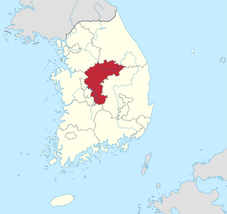
Gyeonggi Province is the most populous province in South Korea.

<span class="mw-page-title-main">Hwanghae Province</span> Historical province of Korea

Hwanghae Province was one of the Eight Provinces of Korea during the Joseon era. Hwanghae was located in the northwest of Korea. The provincial capital was Haeju. The regional name for the province was Haeseo.

<span class="mw-page-title-main">Samcheok</span> Municipal City in Gangwon, South Korea

Samcheok is a city in Gangwon-do, South Korea.

<span class="mw-page-title-main">Hwaseong, Gyeonggi</span> City in Gyeonggi, South Korea

Hwaseong is a city in Gyeonggi Province, South Korea. It has the largest area of farmland of any city or county in Gyeonggi Province. Seoul Subway Line 1 passes through Hwaseong, stopping at Byeongjeom Station. Suin Bundang Line also passes through Hwaseong, stopping at Eocheon Station.

<span class="mw-page-title-main">Korean dialects</span> Dialects of Korean spoken on the Korean Peninsula

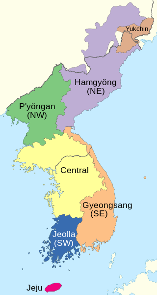
A number of Korean dialects are spoken on the Korean Peninsula. The peninsula is very mountainous and each dialect's "territory" corresponds closely to the natural boundaries between different geographical regions of Korea. Most of the dialects are named for one of the traditional Eight Provinces of Korea. Two are sufficiently distinct from the others to be considered separate languages, the Jeju and the Yukjin languages.

<span class="mw-page-title-main">Gwangju, Gyeonggi</span> Municipal City in Gyeonggi Province, South Korea

Gwangju is a city in Gyeonggi Province, South Korea, a suburb southeast of Seoul. The city is not to be confused with the much larger Gwangju Metropolitan City, former capital of South Jeolla Province, South Korea.

<span class="mw-page-title-main">Anseong</span> Municipal City in Gyeonggi Province, South Korea

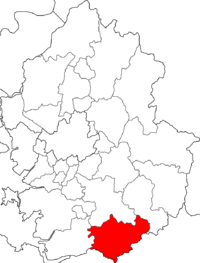
Anseong is a city in Gyeonggi Province, South Korea, 80 kilometres (50 mi) south of Seoul. Its geographical location is 37°0′N127°16′E.

<span class="mw-page-title-main">Gwacheon</span> Municipal City in Gyeonggi Province, South Korea

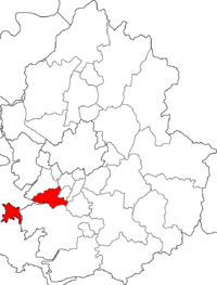
Gwacheon is a city in Gyeonggi Province, South Korea. It lies close to Seoul in the heart of the Seoul National Capital Area, and also lies just east of Anyang. Seoul Subway Line 4 passes through the city.

<span class="mw-page-title-main">Pocheon</span> Municipal City in Gyeonggi Province, South Korea

Pocheon (Korean pronunciation:[pʰo.tsʰʌn]) is an inland city in the far northeastern region of Gyeonggi province in South Korea. It covers 826.48 km (513.55 mi)2 with a population of 160,176 people, according to the 2008 census. Pocheon lies between Seoul and the mountainous northwestern areas of Gangwon province. The city borders Yeoncheon county, with the cities of Dongducheon and Yangju to the west, along with Uijeongbu, and Namyangju of Gyeonggi province to the south. It also borders Hwacheon county of Gangwon province on its eastern border and Cheorwon is to the north. Alongside the adjoining Gapyeong, Pocheon consists of the highest mountainous areas in Gyeonggi province. The current city of Pocheon was created after Pocheon-hyeon and Yeongpyeong counties were merged. The north part of the city used to be part of Yeongpyeong county while the south used to be part of Pocheon-hyeon.

<span class="mw-page-title-main">Siheung</span> Municipal City in Gyeonggi Province, South Korea

Siheung is a city in Gyeonggi Province, South Korea. The city has a population of 511,807 people, where 508,646 are residents out of 218,846 households as of August 2021. Siheung acquired its current administrative structure on January 1, 1989, the former Siheung County was divided into the cities of Siheung, Gunpo, and Uiwang. At the time, Siheung had a population of only 93,000. This number more than tripled in the following decade as massive suburban apartment complexes were developed. Today's Siheung city area formerly belonged to Incheon and Ansan before 1914.

<span class="mw-page-title-main">Uijeongbu</span> Municipal city in Gyeonggi Province, South Korea

Uijeongbu is a city in Gyeonggi Province, South Korea.

<span class="mw-page-title-main">Provinces of South Korea</span>

Provinces are one of the first-level divisions within South Korea. There are 9 provinces in South Korea: North Chungcheong, South Chungcheong, Gangwon Special Self-Governing Province, Gyeonggi, North Gyeongsang, South Gyeongsang, North Jeolla, South Jeolla, and Jeju Special Self-Governing Province.
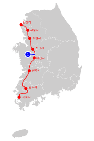
Shinsegae is a South Korean department store franchise, along with several other businesses, headquartered in Seoul, South Korea. The firm is an affiliate of Shinsegae Group, South Korea's leading retail chaebol, and one of the big three department store firms in Korea, along with Lotte and Hyundai Department Store. Its flagship store in Centum City, Busan, was the world's largest department store at 3,163,000 square feet (293,900 m2), surpassing Macy's flagship Herald Square in New York City in 2009.

<span class="mw-page-title-main">Seoul Capital Area</span> Metropolitan area in South Korea

The Seoul Capital Area or Gyeonggi region, is the metropolitan area of Seoul, Incheon, and Gyeonggi Province, located in north-west South Korea. Its population of 26 million is ranked as the fourth largest metropolitan area in the world. Its area is about 12,685 km2 (4,898 sq mi). It forms the cultural, commercial, financial, industrial, and residential center of South Korea. The largest city is Seoul, with a population of approximately 10 million people, followed by Incheon, with 3 million inhabitants.

National Route 43 is a national highway in South Korea connecting Sejong City to Kosong County. It was established on 31 August 1971.
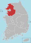
Gyeonggi region is the area of Seoul, Incheon, and Gyeonggi-do, a part of South Korea.