List of cities in Goa by population

Last updated • 2 min readFrom Wikipedia, The Free Encyclopedia

This is a list of cities and towns in Goa . Goa /ˈɡ.ə/ is a state located in the south-western region of India; It is India's smallest state by area and the fourth smallest by population. Goa is one of India's richest states with a GDP per capita two and a half times that of the country. [1] It was ranked the best placed state by the Eleventh Finance Commission for its infrastructure and ranked on top for the best quality of life in India by the National Commission on Population based on the 12 Indicators. [1]

Contents

Panjim is the state capital of Goa. Vasco da Gama is the largest city. Margao is the commercial capital of Goa, while Ponda is considered the cultural capital of the state. Goa still exhibits the religious and cultural influence of the Portuguese, who ruled Goa from 1510 to 1961.

Subdivisions

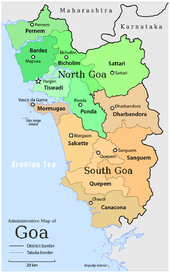
Talukas of Goa. Talukas in green shades belong to North Goa district, and orange denote South Goa district. Administrative map of Goa.png
Talukas of Goa. Talukas in green shades belong to North Goa district, and orange denote South Goa district.

The state is divided into two districts: North Goa and South Goa. Each district is administered by a district collector, appointed by the Indian government.

Panaji is the headquarters of North Goa district and is also the capital of Goa.

North Goa is further divided into three subdivisions – Panaji, Mapusa, and Bicholim; and five taluksTiswadi (Panaji), Bardez (Mapusa), Pernem, Bicholim, and Sattari (Valpoi),(note = the letter m is silent at the end of ever place/city/taluka)

Margao is the headquarters of South Goa district.

South Goa is further divided into five subdivisions – Ponda, Mormugao (Vasco da Gama), Margao, Quepem, and Dharbandora; and seven taluksPonda, Mormugao, Salcete (Margao), Quepem, and Canacona (Chaudi), Sanguem, and Dharbandora. (Ponda Taluka shifted from North Goa to South Goa in January 2015).(note = the letter m is silent at the end of ever place/city/taluka)

Goa's major cities include Vasco da Gama, Margao, Panaji, Mapusa and Ponda.

Panaji is the only Municipal Corporation in Goa. There are thirteen Municipal Councils: Margao, Mormugao (including Vasco da Gama), Pernem, Mapusa, Bicholim, Sanquelim, Valpoi, Ponda, Cuncolim, Quepem, Curchorem, Sanguem, and Canacona.(note = the letter m is silent at the end of ever place/city/taluka)

Cities in Goa

Capital City
Name [2] Type [2] Category [2] TalukaPopulation (2011) [3] [4] Land area [3] [4] District
km2mi2
Bicholim CityMunicipal Council Bicholim 1698614.505.60 North Goa
Canacona CityMunicipal Council Canacona 1243418.707.22 South Goa
Cuncolim CityMunicipal Council Salcete 1662328.7011.08 South Goa
Curchorem CityMunicipal Council Quepem 2273022.608.73 South Goa
Mapusa CityMunicipal Council Bardez 4048711.324.37 North Goa
Margao CityMunicipal Council Salcete 8765021.108.15 South Goa
Mormugao CityMunicipal Council Mormugao 9439327.3610.56 South Goa
Panaji CityMunicipal Corporation Tiswadi 4001708.103.13 North Goa
Pernem CityMunicipal Council Pernem 528915.946.15 North Goa
Ponda CityMunicipal Council Ponda 226645.202.01 South Goa
Quepem CityMunicipal Council Quepem 1479519.707.61 South Goa
Sanguem CityMunicipal Council Sanguem 64444.901.89 South Goa
Sanquelim CityMunicipal Council Bicholim 1365114.705.68 North Goa
Valpoi CityMunicipal Council Sattari 853211.704.52 North Goa

Urban agglomerations in Goa

Capital City
NameUA TypeTalukaPopulation (2011)Land areaUA has following cities & town under it.
km2mi2
Margao UAClass I UAs/Towns Salcete 10648424.19.3 Margao(M.CI), Aquem, Navelim
Mormugao UAClass I UAs/Towns Mormugao 10132639.5515.27 Mormugao(M CI), Chicalim
Panaji UAClass I UAs/Towns Tiswadi 1147597529 Panaji(M Corp.), Taleigao, Durgawado, Morambi-O-Grande, Cujira, Panelim, Morambi-O-Pequeno, Bambolim, Calapor, Chimbel, Murda

Related Research Articles

<span class="mw-page-title-main">Ponda, Goa</span> City in Goa, India

Ponda, is a city and a municipal council in the South Goa district of Goa, India. Located in the central area of Goa, Ponda lies 28 km southeast of Panaji, the capital of Goa and 17 km northeast of Margao, the district headquarters. Ponda is also known as "Antruz Mahal" because of its numerous famous temples and the area's rich cultural heritage.

<span class="mw-page-title-main">Canacona taluka</span> Taluka (city) of Goa

Canacona is an administrative region in the district of South Goa, Goa state, India.

<span class="mw-page-title-main">Zuari River</span> River in India

The Zuari RiverZuvari, pronounced ) is the largest river in the state of Goa, India. It is a tidal river which originates at Hemad-Barshem in the Western Ghats. The Zuari is also referred to as the Aghanashani in the interior regions. It flows in a south-westerly direction through the talukas of Tiswadi, Ponda, Mormugao, Salcete, Sanguem and Quepem.

<span class="mw-page-title-main">Salcete</span> Taluka in South Goa, India

Salcete or Salcette is a subdivision of the district of South Goa, in the state of Goa, situated by the west coast of India. The River Sal and its backwaters dominate the landscape of Salcete. Historically, the sixty-six settlements south of the Zuari River formed the original Salcette territory. Salcete forms a part of the bigger Konkan region that stretches along the western shoreline of peninsular India.
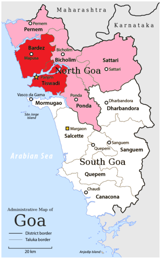
<span class="mw-page-title-main">North Goa district</span> District in Goa, India

North Goa district is one of the two districts that constitutes the state of Goa, India. The district has an area of 1,736 square kilometres, and is bounded by Kolhapur and Sindhudurg districts of Maharashtra state to the north and by Belgavi district of Karnataka to the east, by South Goa district to the south, and by the Arabian Sea to the west.
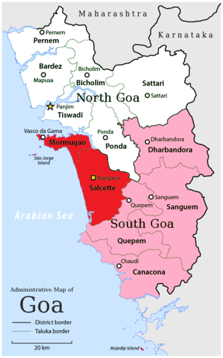
<span class="mw-page-title-main">South Goa district</span> District of Goa in India

South Goa district is one of two districts that together constiitue the state of Goa, India, within the region known as the Konkan. It is bounded by North Goa district to the north, the Uttara Kannada district of Karnataka state to the east and south, while the Arabian Sea forms its western coast.

<span class="mw-page-title-main">Vasco da Gama, Goa</span> City in Goa, India

Vasco da Gama, often shortened to Vasco, is a city in the state of Goa on the west coast of India. It is named after the Portuguese explorer Vasco da Gama. It is the headquarters of the Mormugão taluka (subdistrict). The city lies on the western tip of the Mormugao peninsula, at the mouth of the Zuari River, about 30 kilometres (19 mi) from Panaji, Goa's capital, 28 kilometres (17 mi) from Margao, the district headquarters and about 5 kilometres (3.1 mi) from Dabolim Airport.

<span class="mw-page-title-main">Novas Conquistas</span> Region in Estado da India, Portuguese Empire

The Novas Conquistas or "New Conquests" are a group of seven concelhos (municipalities) of Goa and Damaon, officially known as Portuguese India. They were added into Goa in the 18th century AD, a comparatively later date than the original three concelhos that make up the Velhas Conquistas or "Old Conquests".

<span class="mw-page-title-main">Mormugao</span> City in Goa, India

Mormugao is a seaport city situated in the eponymous Mormugao taluka (municipality) of the South district, in the Goa state, India. It has a deep natural harbour and remains Goa's chief port.

<span class="mw-page-title-main">Ponda taluka</span> Taluka in Goa, India

Pondataluka is a subdivision of the district of north Goa, in the Indian state of Goa. Its administrative headquarters is the township of Ponda.

<span class="mw-page-title-main">Goa</span> State in Western India

Goa is a state on the southwestern coast of India within the Konkan region, geographically separated from the Deccan highlands by the Western Ghats. It is bound by the Indian states of Maharashtra to the north, and Karnataka to the east and south, with the Arabian Sea in the west. It is India's smallest state by area and fourth-smallest by population. Goa has the highest GDP per capita among all Indian states, two and a half times as high as the GDP per capita of the country as a whole. The Eleventh Finance Commission of India named Goa the best-placed state because of its infrastructure, and India's National Commission on Population rated it as having the best quality of life in India. It is the second-highest ranking among Indian states in the human development index.

<span class="mw-page-title-main">Directorate of Fire and Emergency Services, Goa</span>

The Directorate of Fire and Emergency Services, Goa is the fire brigade run by the Government of Goa.

Loliem Railway Station a railway station in Goa, under the jurisdiction of the Konkan Railway.

Balli Railway Station is a smaller railway station in Goa, under the jurisdiction of Konkan Railway. It lies is in Balli village off the highway connecting Chandor to Canacona.

Suravali Railway Station is a smaller railway station in Goa.
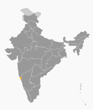
<span class="mw-page-title-main">Outline of Goa</span> Overview of and topical guide to Goa

The following outline is provided as an overview of and topical guide to Goa:
References

  1. 1 2 Reports of the finance commissions of India: First Finance Commission to the Twelfth Finance Commission: the complete report. India. Finance Commission. Academic Foundation. 2005. p. 268. ISBN   81-7188-474-1.{{cite book}}: CS1 maint: others (link)
  2. 1 2 3 "ALPHABETICAL LIST OF TOWNS AND THEIR POPULATION" (PDF). Censusindia.gov.in. Retrieved 10 June 2016.
  3. 1 2 "GOA : SERIES-31 PART XII-B : DISTRICT CENSUS HANDBOOK : NORTH GOA" (PDF). Censusindia.gov.uk. Retrieved 10 June 2016.
  4. 1 2 "GOA : SERIES-31 PART XII-B : DISTRICT CENSUS HANDBOOK : SOUTH GOA" (PDF). Censusindia.gov.uk. Retrieved 10 June 2016.