Tiswadi

Last updated

Tiswadi
(Portuguese: Ilhas de Goa, lit. 'Islands of Goa')
Tiswadi taluka in North Goa district.png
Location of Tiswadi in North Goa, Goa
Coordinates: 15°29′55″N73°49′46″E / 15.498598°N 73.829341°E / 15.498598; 73.829341
Country Flag of India.svg  India
State Goa
District North Goa
Headquarters Panaji
Settlements1 City
9 Towns
22 Villages
Government
   Tehsildar na
   Lok Sabha constituency North Goa
   Assembly constituency na
   MLA na
Population
 (2011)
  Total177,219
Demographics
   Literacy rate 81.83%
  Sex ratio966
Vehicle registration GA-07
Rainna

Tiswadi, formerly known as Ilhas de Goa, is a sub district in the district of North Goa, situated in the Indian coastal state of Goa. It is an estuarine island situated on the confluence of the Mandovi and Zuari rivers. It was one of the first territories to be annexed by Portugal in the sixteenth century. Both the state capital Panaji, and the erstwhile capital Old Goa lie within the subdistrict. It is the biggest and most populated of the six major islands between the Mandovi and Zuari rivers.

Contents

It is made up of 7 major islands within the Mandovi, namely:

Etymology

The word Tiswadi itself, originated in the late 1970s and it referred to thirty settlements of the Gaud Saraswat Brahmans who settled here after they migrated to Goa from Aryavarta. The descendants of these settlers now form the native Bammon (Catholic Brahman) community.[ citation needed ]

The previous official name Ilhas de Goa simply means Islands of Goa, in Portuguese. [1]

Geography

It is geographically made up of several small riverine islands within the Mandovi River forming its northern boundary, the Cumbarjua Canal making its eastern border, and the Zuari River making up its southern border.

As the native name suggests, the sub-district includes the smaller islands of:

History

Tiswadi, along with the rest of Goa, regularly exchanged hands between the Muslim Bhahmani Sultanate and the Hindu Vijayanagara Empire of South India prior to the 14th century. By the 15th century, the Bijapur Sultanate under the Adil Shahi dynasty conquered Goa, and it came under Muslim rule. The City of Goa was the regional capital of the sultanates as well as a hub for the Hajj pilgrimage. Numerous temples were demolished under the rule of the sultanates. The Adil Shahi dynasty was defeated by a Portuguese–Vijayanagar alliance, and Ilhas de Goa was conquered under Afonso de Albuquerque in 1510. By the time Tiswadi was relieved from Muslim rule, Hindus formed a minority in the region, and the Portuguese started conversion efforts against the Muslim majority. The populace was made to accept Christianity or leave the islands. There was a mass exodus of natives who left the islands, for the safer havens of Ponda and the Canara, Malabar Coast, Chandgad and Joida.[ citation needed ]

The first temple to be built in Panjim was in the mid-1700s, when the Portuguese authorities granted permission to the Hindus to build their place of worship.[ citation needed ]

The evangelization of Tiswadi was spearheaded by the Dominicans, who were assigned 15 villages, and the Jesuits, who were assigned the remaining part along with the smaller islands of Chorão and Divar, by the Portuguese authorities. In 1552, the island of Chorão had a population of 300 Christians out of 3,000 and, by this time, also had a small church which was visited by a Jesuit from St. Paul's every Sunday. By the end of 1559, over 1,200 had accepted baptism. The following year, the first bishop from the Jesuit order, Dom João Nunes de Barreto, set up residence in Chorão, which eventually became a Noviciate. Most of Chorão's population converted en masse to Roman Catholicism in mid-1560. [2]

By January 1563, the Jesuit provincial claimed that Ilhas de Goa had been completely Christianized, with a population of 70,000, the great majority of which had converted in the last six years, corresponding to the terms of Viceroys Francisco Barreto and Constantino of Braganza, whose 2+12-year term saw between 25,000 and 30,000 conversions. [2]

Demographics

As per the 2011 Census of India, Tiswadi Taluka has a population of 177,219 people. The sex-ratio of Tiswadi Taluka is around 966, compared to the state average of 973. The literacy rate of Tiswadi Taluka is 81.83% out of which 84.49% males are literate and 79.07% females are literate. The total area of Tiswadi is 193.64 sq.km with population density of 915 per sq.km. Out of total population, 21.19% of population of the Taluka lives in Urban area and 78.81% lives in Rural area. [3]

Languages

At the time of the 2011 Census of India, 65.51% of the population of Tiswadi Taluka spoke Konkani, 10.63% Hindi, 6.62% Marathi, 5.26% Kannada and 2.77% Urdu as their first language. [4]


Languages of Tiswadi Taluka (2011)

   Konkani (65.51%)
   Hindi (10.63%)
   Marathi (6.62%)
   Kannada (5.26%)
   Urdu (2.77%)
  Others (9.21%)

Religion

The majority of the population in Tiswadi Taluka follow Hinduism, although Christians and Muslims are a significant minority.

62.50% of the population in the Taluka follow Hinduism, 27.73% Christianity, 9.27% Islam and the remaining 0.50% follow other religions or stated no religion. [3]


Religion in Tiswadi Taluka
ReligionPercent
Hinduism
62.50%
Christianity
27.73%
Islam
9.27%
Others
0.50%


Highlights

Panjim, Velha Goa and its monuments, Divar, Chorão

Settlements

Cities

#CityStatePopulation
1Panjim Municipal CorporationGoa40000

Towns

#TownStatePopulation
1 Chimbel Census TownGoa15,289
2 Calapor or Santa Cruz, Goa Census TownGoa14,077
3Murda, Census TownGoa7,517
4 Bambolim Census TownGoa6,885
5 Corlim Census TownGoa6,568
6 Mercurim Census TownGoa4,970
7 Cumbarjua Census TownGoa4,917
8 Goa Velha Census TownGoa4,322
9Jua Census TownGoa4,134
10 Old Goa (Velha Goa) Census TownGoa2,550
11 Ribandar Census TownGoa2,450
12 Tiswadi Census TownGoa2,300

Villages

#VillagesAdministrative DivisionPopulation
1AmbarimTiswadi93
2AzossimTiswadi1,142
3BainguinimTiswadi1,501
4BatimTiswadi1,489
5CapãoTiswadi135
6CaraimTiswadi202
7CarambolimTiswadi5,179
8ChorãoTiswadi5,268
9CurcaTiswadi2,518
10EllaTiswadi5,372
11GancimTiswadi519
12GandaulimTiswadi301
13Goalim MoulaTiswadi441
14GoltimTiswadi1,634
15MalarTiswadi1,630
16MandurTiswadi3,113
17NaroaTiswadi487
18NavelimTiswadi1,133
19Neura-O-GrandeTiswadi1,440
20Neura-O-PequenoTiswadi563
21 Siridão Tiswadi2,417 [5]
22TalaulimTiswadi972

See also

Related Research Articles

<span class="mw-page-title-main">Old Goa</span> City in Goa, India

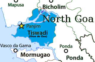
Old Goa is a historical site and city situated on the southern banks of the River Mandovi, within the Tiswadi taluka (Ilhas) of North Goa district, in the Indian state of Goa.

<span class="mw-page-title-main">Panaji</span> City in Goa, India

Panaji is the capital of the Indian state of Goa and the headquarters of North Goa district. Previously, it was the territorial capital of the former Portuguese India. It lies on the banks of the Mandovi river estuary in the Tiswadi sub-district (taluka). With a population of 114,759 in the metropolitan area, Panaji is Goa's largest urban agglomeration, ahead of Margao and Mormugao.

<span class="mw-page-title-main">Mandovi River</span> River in southwest India

The Mandovi, also known as the Mhadei, is a river described as the lifeline of the Indian state of Goa. The Mandovi and the Zuari are the two principal rivers in the state of Goa. Mandovi joins with the Zuari at a common creek at Cabo Aguada, forming the Mormugao harbour. Panaji, the state capital and Old Goa, the former capital of Goa, are both situated on the left bank of the Mandovi.

<span class="mw-page-title-main">Ribandar</span> Town in Goa, India

Ribandar is a town in Tiswadi, Goa, located between the cities of Panjim and Old Goa.

<span class="mw-page-title-main">North Goa district</span> District of Goa in India

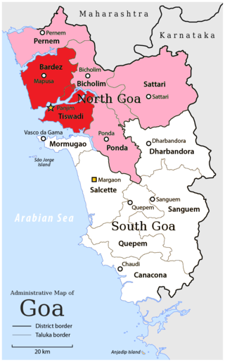
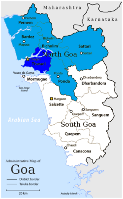
North Goa district is one of the two districts that constitutes the state of Goa, India. The district has an area of 1,736 square kilometres, and is bounded by Kolhapur and Sindhudurg districts of Maharashtra state to the north and by Belgavi district of Karnataka to the east, by South Goa district to the south, and by the Arabian Sea to the west.

<span class="mw-page-title-main">Chorão (island)</span> Island in Goa, India

Chorão, also known as Choddnnem or Chodan, is an island along the Mandovi River near Tiswadi, Goa, India. It is the largest among other 17 islands of Goa. It is located 5 kilometres away from the state capital, the city of Panaji and 10 kilometres away from the city of Mapusa.

<span class="mw-page-title-main">Divar</span> Island in Goa, India

The island of Divar lies in the Mandovi river in the Indian state of Goa.

Cumbarjua, is an island and town within the Mandovi River in Goa. It is situated to the east of Goa's capital Panjim at a distance of 20 kilometres.

Rachol is a prominent village in the Salcete taluka (subdistrict) of South Goa district, Goa state, peninsular India. It is located on the left bank of the Zuari River and is home to the famous Rachol Seminary. The famous Portuguese colonial Rachol Fort has been completely erased, leaving behind the traces of the moat and the main gate. The village has many heritage structures and is an important site to study the history of Salcete. The Church of Our Lady of Snows at Rachol is said to be the first church of Salcete and is called the Matriz igreja de Salcette. Ilha de Rachol is a part of the village.

<span class="mw-page-title-main">Christianity in Goa</span> Type of religion in Goa, India

The Christian population is almost entirely Goan Catholics, whose ancestors converted to Christianity during Portuguese rule. Christianisation followed the Portuguese conquest of Goa in 1510, which was followed by the Goa Inquisition from 1560 onwards. The Hindu population is mostly descended from immigrants from other states of India, who have been arriving in Goa since the last century There is a higher proportion of Christians in Velhas Conquistas than in Novas Conquistas.

St Estevam is an estuarine islet in the Tiswadi taluka, Goa state, India. St Estevam is commonly referred as Jūvã (Isle) and has earned the monicker Šākêchô Jūvõ—the island of vegetables—famed for its long, seven-ridged, light green ladyfingers. Therefore, the people of Jūvã came to be nicknamed bhennddem. The island is named after St. Stephen. It is one of Goa's most prosperous villages, often quoted by ex-Chief Minister Pratapsingh Rane for having a high per capita income.

<span class="mw-page-title-main">São Matias, Goa</span> Village in Goa, India

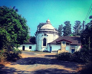
São Mathias also known as Malar is a village on Divar Island, Tiswadi or Ilhas, in the Indian state of Goa. The island is located 10 km upriver from Panjim.

<span class="mw-page-title-main">Goan Muslims</span>

The Goan Muslims are a minority community who follow Islam in the Indian coastal state of Goa, some are also present in the union territory of Damaon, Diu & Silvassa. They are native to Goa, unlike recent Muslim migrants from mainland India and are commonly referred to as Moir by Goans in Goan Konkani. Moir is derived from the Portuguese word Mouro. The Portuguese called them Mouros because they were in contact with the Moors, people of predominantly Muslim Maghreb country, who had conquered and colonised the Iberian peninsula for centuries.

<span class="mw-page-title-main">Vanxim</span> Island and Village in Goa, India

Vanxim or Capão is an island of Goa situated in the Ilhas region. One can reach here by taking a ferry from Divar. The colonial name for Vanxim was Capão. One may see a lot of houses with few villagers many of whom are fisher-folk in the area. Silveiras, Furtados, Vas, Olivera are surnames of people. Mahendra Gaunekar sold the parts of the island to Ozone corporate. Luxury hotel and Golf Course is sort to be forced upon this island but faced resistance from alert islanders and others.

<span class="mw-page-title-main">Piedade, Goa</span> Village in Goa, India

Piedade is an island village located in Ilhas, a northern district in the state of Goa, India, and named after Our Lady of Compassion. The name comes from the Portuguese word piedade, which means "compassion". It lies 23 km east of the state capital, Panjim, between the taluks of Satari and Ponda. Other nearby villages are Amona (3 km), Volvoi (3 km), Surla (4 km), Cudnem (4 km), Betqui, and Candola (5 km).

Santa Cruz Assembly constituency is one of the original Goa Legislative Assembly constituency seats in the Tiswadi Taluka of North Goa District in the State of Goa. The other constituencies in Tiswadi are Panaji, Taleigao, St. Andre and Cumbarjua.

<span class="mw-page-title-main">Naroa, Ilhas, Goa</span> Village in Goa, India

Naroa is a village located on the eastern tip of the island of Divar, in the Indian state of Goa. It has a population of barely a thousand people, with about 80 houses.

The Cumbarjua Canal is a distributary channel formed by the merger of the Mandovi and Zuari rivers in Goa, India. It's flow has led to the formation of river deltas, most prominent of them are - Ilhas de Goa, Cumbarjua and St Estevam.

The Island of Goa is the largest estuarine island in the Indian state of Goa. It is situated on the confluence of the Mandovi and Zuari rivers. Due to its name, it is often confused with Ilhas de Goa which means Islands of Goa (plural).

References

  1. "Definitions for ilhas".
  2. 1 2 Sarasvati's Children: A History of the Mangalorean Christians, Alan Machado Prabhu, I.J.A. Publications, 1999, pp. 100–101.
  3. 1 2 "C-1 Population By Religious Community". census.gov.in. Retrieved 15 September 2020.
  4. "C-16 Population By Mother Tongue - Goa". censusindia.gov.in. Retrieved 4 October 2019.
  5. "Siridao Village Population - Tiswadi - North Goa, Goa". Census 2011 India. 29 May 1980. Retrieved 17 November 2016.