List of counties of Scotland 1890–1975

Last updated

This is a list of counties of Scotland created by the Local Government (Scotland) Act 1889 and abolished in 1975 by the Local Government (Scotland) Act 1973. The list includes the county town, area, and population density.

Contents

Counties

CountyCounty town [1] Alternative forms and Gaelic nameArea (acres) [2] Area (km2) [3] Population [4] Population
density
(per km2) [5]
Inverness-shire Inverness 2,695,09410,915.1389,6558.21
Argyll Lochgilphead Argyllshire; Argyle; Earra-Ghaidheal2,067,034 [6] 8,364.9859,7777.15
Ross and Cromarty Dingwall Ross-shire1,977,2548,007.8858,2847.28
Perthshire [7] Perth 1,586,577 [8] 6,425.63127,10419.78
Sutherland Dornoch [9] 1,297,9145,276.0713,0552.47
Aberdeenshire Aberdeen 1,246,585 [10] 5,172.55150,703 [11] 29.14
Ayrshire Ayr 724,239 [12] 2,930.95361,248123.25
Dumfriesshire Dumfries 688,067 [13] 2,784.5688,21531.68
Kirkcudbrightshire Kirkcudbright The Stewartry574,0242,324.7927,36911.77
Angus Forfar Forfarshire540,352 [14] 2,186.7797,31244.50
Lanarkshire Hamilton (historically Lanark)535,605 [15] 2,169.20626,787288.95
Caithness Wick Gallaibh438,8331,775.9327,79215.65
Roxburghshire Jedburgh [16] 425,5641,725.2441,96024.32
Banffshire Banff 403,0541,631.1443,50026.67
Zetland Lerwick Shetland, Sealltainn, Hjaltilandc.3,523.37 [17] 1,425.85 [18] 17,33112.15
Fife Cupar Fifeshire, Fiobha322,8781,306.67327,126250.35
Wigtownshire Wigtown The Shire311,9841,262.5827,33721.65
Moray [19] Elgin Morayshire, Elginshire, Moireabh304,9311,234.9751,50241.70
Berwickshire Duns (anciently Berwick-upon-Tweed, and then Greenlaw)292,535 [17] 1,183.8420,77817.55
Stirlingshire Stirling 288,3491,166.90208,958179.07
Kincardineshire Stonehaven (historically Kincardine)The Mearns, A' Mhaoirne244,428 [20] 989.9326,06626.33
Orkney Kirkwall Arcaibh, Orkneyjarc.240,848 [17] 934.67 [21] 17,08218.28
Peeblesshire Peebles 222,240900.0713,67515.19
Midlothian Edinburgh Edinburghshire203,354 [22] 823.58142,213172.68
Selkirkshire Selkirk 171,209 [23] 692.8520,86830.12
East Lothian Haddington Haddingtonshire171,044 [24] 692.7355,90880.71
Dunbartonshire Dumbarton Dumbartonshire154,467 [25] 625.11237,540380.00
Renfrewshire Renfrew 143,829 [17] 578.00362,130626.52
Bute Rothesay Buteshire139,711 [17] 565.3913,30923.54
Nairnshire [19] Nairn 104,251422.2111,05026.17
West Lothian Linlithgow Linlithgowshire76,859 [17] 311.03108,484348.79
Kinross-shire [7] Kinross 52,025 [26] 210.706,42330.48
Clackmannanshire Alloa (historically Clackmannan)34,838140.9945,544323.03

Cities

Historically cities were parts of larger counties. Edinburgh was in Midlothian, Aberdeen in Aberdeenshire, and Glasgow in Lanarkshire (although parts of greater Glasgow extended into other counties, e.g. Dunbartonshire and Renfrewshire).

CountyCounty town [1] Alternative forms and Gaelic nameArea (acres) [2] Area (km2) [3] Population [4] Population density
(per km2) [5]
City of Glasgow Glasgow Glaschu, Glesca, Glasgie34,647 [17] 140.21897,4846,401.00
City of Edinburgh Edinburgh Dun Eideann, Embra, Edina, Dunedin, Auld Reekie32,415 [17] 131.17453,5853,457.99
City of Dundee Dundee Dùn Dè12,229 [17] 49.48182,2043,682.33
City of Aberdeen Aberdeen Obar Dheathain, Aiberdein16,715 [27] 67.64182,0712,691.77

See also

Notes

  1. 1 2 Keay & Keay (1994)
  2. 1 2 Keay & Keay (1994) unless otherwise stated.
  3. 1 2 Keay & Keay (1994) in cases where the area is provided by this author. Otherwise the figure is a calculation based on the assumed area.
  4. 1 2 United Kingdom 1971 Census
  5. 1 2 Calculated from 1971 Census data and 'Area'.
  6. Argyllshire is reduced to a land area of 1,990,521 acres (8055.35 km²) if "waters, marsh and foreshore" are excluded from the total.
  7. 1 2 Perth and Kinross were administered as a "combined county" from 1930-1975.
  8. Reduced from 1,595,804 acres (6,457.99 km2) in 1951.
  9. According to Keay (1994) Dornoch was generally 'considered' to be the county town of Sutherland, although the council offices were in Golspie.
  10. Possibly reduced from 1,263,300 acres (5,112 km2) in 1951 but see 'City of Aberdeen' below).
  11. "Aberdeenshire District: Total Population" A Vision of Britain. Retrieved 27 December 2007.
  12. Increased from 724,232 acres (2,930.86 km2) in 1951.
  13. Reduced from 688,111 acres (2,784.69 km2) in 1951.
  14. Reduced from 546,775 acres (2,212.72 km2) in 1951.
  15. Reduced from 535,862 acres (2,168.56 km2) in 1951.
  16. According to Keay (1994) the county town was Newtown St Boswells. The County Offices had moved there in 1899. "Overview of Jedburgh". Gazetteer for Scotland. The Institute of Geography, University of Edinburgh. Retrieved 1 August 2008. However, the county town is usually listed as Jedburgh, e.g. in Encyclopedia II op cit and "Carnegie Libraries" scotcities.com Retrieved 26 December 2007.
  17. 1 2 3 4 5 6 7 8 9 The areas for Berwickshire, Bute, Orkney, Renfrewshire, West Lothian and Zetland and the three cities are not provided by Keay (1994) and the figures used are from the 1951 census.
  18. The current figure for Orkney Islands Council is 1,466 km2 for the same geographical area.
  19. 1 2 Moray and Nairn were administered as a "combined county" from 1930-1975.
  20. Reduced from 242,460 acres (981.2 km2) in 1951.
  21. The current figure for Orkney Islands Council is 990 km² for the same geographical area.
  22. Increased from 201,922 acres (817.15 km2) in 1951.
  23. Keay (1994) provides the figure of 121,240 acres (490.6 km2). This is probably a typographical error for 171,240 acres (693.0 km2). For example, the 1976 World Book has a figure of 695 km2 for the county. The 1951 Census figure is used in this column.
  24. Increased from 170,971 acres (691.90 km2) in 1951.
  25. Increased from 154,362 acres (624.68 km2) in 1951.
  26. Reduced from 52,392 acres (212.02 km2) in 1951.
  27. Neither Keay (1994) or Vision of Britain offer a specific statistic. However the latter records a total area of 1,263,300 acres (5,112 km2) for 'Aberdeen'. This is clearly inclusive of Aberdeenshire, which elsewhere in the same database recorded as having an area of 1,246,585 acres (5,044.75 km2). The figure recorded here is the difference between the two. In general terms this is consistent with the Vision of Britain maps for the area.

Related Research Articles

<span class="mw-page-title-main">Aberdeenshire</span> Council area of Scotland

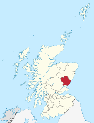
Aberdeenshire is one of the 32 council areas of Scotland.

<span class="mw-page-title-main">Angus, Scotland</span> Council area of Scotland

Angus is one of the 32 local government council areas of Scotland, a registration county and a lieutenancy area. The council area borders Aberdeenshire, Dundee City and Perth and Kinross. Main industries include agriculture and fishing. Global pharmaceuticals company GSK has a significant presence in Montrose in the east of the county.

<span class="mw-page-title-main">Scottish Highlands</span> Cultural and historical region of Scotland

The Highlands is a historical region of Scotland. Culturally, the Highlands and the Lowlands diverged from the Late Middle Ages into the modern period, when Lowland Scots language replaced Scottish Gaelic throughout most of the Lowlands. The term is also used for the area north and west of the Highland Boundary Fault, although the exact boundaries are not clearly defined, particularly to the east. The Great Glen divides the Grampian Mountains to the southeast from the Northwest Highlands. The Scottish Gaelic name of A' Ghàidhealtachd literally means "the place of the Gaels" and traditionally, from a Gaelic-speaking point of view, includes both the Western Isles and the Highlands.

<span class="mw-page-title-main">Highland (council area)</span> Council area of Scotland

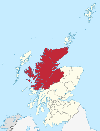
Highland is a council area in the Scottish Highlands and is the largest local government area in the United Kingdom. It was the 7th most populous council area in Scotland at the 2011 census. It shares borders with the council areas of Aberdeenshire, Argyll and Bute, Moray and Perth and Kinross. Their councils, and those of Angus and Stirling, also have areas of the Scottish Highlands within their administrative boundaries.

<span class="mw-page-title-main">Moray</span> Council area of Scotland

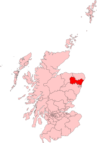
Moray is one of the 32 local government council areas of Scotland. It lies in the north-east of the country, with a coastline on the Moray Firth, and borders the council areas of Aberdeenshire and Highland.

<span class="mw-page-title-main">Renfrewshire</span> Council area of Scotland

Renfrewshire is one of the 32 council areas of Scotland.

<span class="mw-page-title-main">Local government in Scotland</span> System of state administration on a local level in Scotland

Local government in Scotland comprises thirty-two local authorities, commonly referred to as councils. Each council provides public services, including education, social care, waste management, libraries and planning. Councils receive the majority of their funding from the Scottish Government, but operate independently and are accountable to their local electorates. Councils raise additional income via the Council Tax, a locally variable domestic property tax, and Business rates, a non-domestic property tax.

<span class="mw-page-title-main">Shires of Scotland</span> Historic administrative and geographical division of Scotland

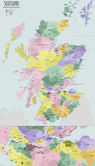
The shires of Scotland, or counties of Scotland, are historic subdivisions of Scotland established in the Middle Ages and used as administrative divisions until 1975. Originally established for judicial purposes, from the 17th century they started to be used for local administration purposes as well. The areas used for judicial functions (sheriffdoms) came to diverge from the shires, which ceased to be used for local government purposes after 1975 under the Local Government (Scotland) Act 1973.

<span class="mw-page-title-main">Inverurie</span> Town in northeast Scotland

Inverurie is a town in Aberdeenshire, Scotland at the confluence of the rivers Ury and Don, about 16 miles (26 km) north-west of Aberdeen.

<span class="mw-page-title-main">Lieutenancy area</span> Separate areas of the United Kingdom appointed a lord-lieutenant

Lieutenancy areas, officially counties and areas for the purposes of the lieutenancies, are the separate areas of the United Kingdom appointed to a lord-lieutenant – a representative of the British monarch. In many cases they have similar demarcation and naming to, but are not necessarily coterminate with, the counties of the United Kingdom.

<span class="mw-page-title-main">Roxburghshire</span> Historic county in Scotland

Roxburghshire or the County of Roxburgh is a historic county and registration county in the Southern Uplands of Scotland. It borders Dumfriesshire to the west, Selkirkshire and Midlothian to the northwest, and Berwickshire to the north. To the southwest it borders Cumberland and to the southeast Northumberland, both in England.

<span class="mw-page-title-main">Aberdeenshire (historic)</span> Historic county in Scotland

Aberdeenshire or the County of Aberdeen is a historic county and registration county of Scotland. The area of the county, excluding the Aberdeen City council area itself, is also a lieutenancy area. The county borders Kincardineshire, Angus and Perthshire to the south, Inverness-shire and Banffshire to the west, and the North Sea to the north and east. It has a coast-line of 65 miles (105 km). The county gives its name to the modern Aberdeenshire council area, which covers a larger area than the historic county.

<span class="mw-page-title-main">Aberdeen North (UK Parliament constituency)</span> Parliamentary constituency in the United Kingdom, 1885 onwards

Aberdeen North is a burgh constituency of the House of Commons of the Parliament of the United Kingdom and it elects one Member of Parliament (MP) by the first past the post system of election. It was first used in the 1885 general election, but has undergone various boundary changes since that date. The seat has been held by Kirsty Blackman of the Scottish National Party since 2015.

<span class="mw-page-title-main">Gordon (UK Parliament constituency)</span> Parliamentary constituency in the United Kingdom, 1983 onwards

Gordon was a county constituency of the House of Commons of the Parliament of the United Kingdom (Westminster), which elected one member of Parliament (MP) by the first past the post system of election. The constituency was first contested at the 1983 UK general election; and underwent boundary throughout its existence.

<span class="mw-page-title-main">Scottish Westminster constituencies</span> Scottish constituencies of the House of Commons of the Parliament of Great Britain

Scottish Westminster constituencies were Scottish constituencies of the House of Commons of the Parliament of Great Britain, normally at the Palace of Westminster, from 1708 to 1801, and have been constituencies of the House of Commons of the Parliament of the United Kingdom, also at Westminster, since 1801. Constituency boundaries have changed on various occasions, and are now subject to both periodical and ad hoc reviews of the Boundary Commission for Scotland.

<span class="mw-page-title-main">Index of United Kingdom–related articles</span>

The following is an alphabetical list of articles related to the United Kingdom.

This is a list of listed buildings in Scotland. The list is split out by council area.

References