
Perthshire, officially the County of Perth, is a historic county and registration county in central Scotland. Geographically it extends from Strathmore in the east, to the Pass of Drumochter in the north, Rannoch Moor and Ben Lui in the west, and Aberfoyle in the south; it borders the counties of Inverness-shire and Aberdeenshire to the north, Angus to the east, Fife, Kinross-shire, Clackmannanshire, Stirlingshire and Dunbartonshire to the south and Argyllshire to the west. It was a local government county from 1890 to 1930.

The Scottish Borders is one of 32 council areas of Scotland. It borders the City of Edinburgh council area, Dumfries and Galloway, East Lothian, Midlothian, South Lanarkshire, West Lothian and, to the south-west, south and east, the English unitary authorities of Cumberland and Northumberland. The administrative centre of the area is Newtown St Boswells.

Lanarkshire, also called the County of Lanark, is a historic county, lieutenancy area and registration county in the Central Lowlands of Scotland. The county is no longer used for local government purposes, but gives its name to the two modern council areas of North Lanarkshire and South Lanarkshire.

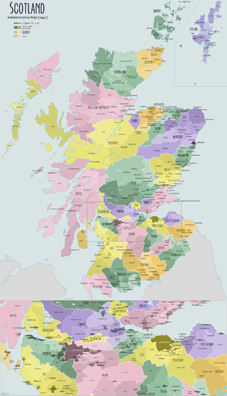
The shires of Scotland, or counties of Scotland, are historic subdivisions of Scotland established in the Middle Ages and used as administrative divisions until 1975. Originally established for judicial purposes, from the 17th century they started to be used for local administration purposes as well. The areas used for judicial functions (sheriffdoms) came to diverge from the shires, which ceased to be used for local government purposes after 1975 under the Local Government (Scotland) Act 1973.
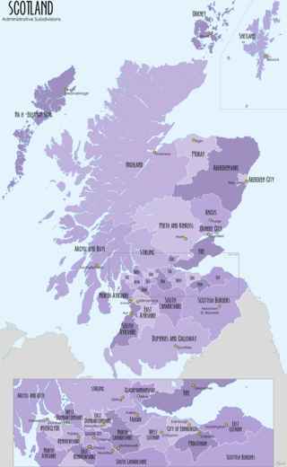
For local government purposes, Scotland is divided into 32 areas designated as "council areas", which are all governed by single-tier authorities designated as "councils". They have the option under the Local Government (Scotland) Act 1997 of being known as a "comhairle" when opting for a Gaelic name; only Comhairle nan Eilean Siar has chosen this option, whereas the Highland Council has adopted its Gaelic form alongside its English equivalent, informally.

Sutherland is a historic county, registration county and lieutenancy area in the Highlands of Scotland. Its county town is Dornoch. Sutherland borders Caithness and Moray Firth to the east, Ross-shire and Cromartyshire to the south and the Atlantic to the north and west. Like its southern neighbour Ross-shire, Sutherland has some of the most dramatic scenery in Europe, especially on its western fringe where the mountains meet the sea. These include high sea cliffs, and very old mountains composed of Precambrian and Cambrian rocks.


Roxburghshire or the County of Roxburgh is a historic county and registration county in the Southern Uplands of Scotland. It borders Dumfriesshire to the west, Selkirkshire and Midlothian to the northwest, and Berwickshire to the north. To the southwest it borders Cumberland and to the southeast Northumberland, both in England.

Selkirkshire or the County of Selkirk is a historic county and registration county of Scotland. It borders Peeblesshire to the west, Midlothian to the north, Roxburghshire to the east, and Dumfriesshire to the south. It derives its name from its county town, the royal burgh of Selkirk. The county was historically also known as Ettrick Forest.

Stirlingshire or the County of Stirling, Scottish Gaelic: Siorrachd Sruighlea) is a historic county and registration county of Scotland. Its county town is Stirling.


Netherlee is a suburban residential area in East Renfrewshire, Scotland. It is situated on the west bank of the White Cart Water about 4 miles (6.5 km) south of Glasgow city centre. Part of the Greater Glasgow conurbation, it is mostly contiguous with the city, and is just beyond the boundary of its local authority area. It is a separate census locality from Glasgow, like other areas such as neighbouring Giffnock and Clarkston. Netherlee is directly contiguous with Stamperland. It is also in a council ward with Clarkston and its neighbour Busby. As of 2012, Netherlee has a population of 4,550.
The General Register Office for Scotland (GROS) was a non-ministerial directorate of the Scottish Government that administered the registration of births, deaths, marriages, divorces and adoptions in Scotland from 1854 to 2011. It was also responsible for the statutes relating to the formalities of marriage and conduct of civil marriage in Scotland. It administered the census of Scotland's population every ten years. It also kept the Scottish National Health Service Central Register.
The Local Government (Scotland) Act 1929 reorganised local government in Scotland from 1930, introducing joint county councils, large and small burghs and district councils. The Act also abolished the Scottish poor law system with institutions passing to the local authorities.
Civil parishes are small divisions used for statistical purposes and formerly for local government in Scotland.