Related Research Articles
Rensselaer County is a county in the U.S. state of New York. As of the 2020 census, the population was 161,130. Its county seat is Troy. The county is named in honor of the family of Kiliaen van Rensselaer, the original Dutch owner of the land in the area.

Coles County is a county in Illinois. As of the 2020 census, the population was 46,863. Its county seat is Charleston, which is also the home of Eastern Illinois University.

Lonoke County is located in the Central Arkansas region of the U.S. state of Arkansas. As of the 2010 census, the population was 68,356, making it the 11th-most populous of Arkansas's 75 counties. The county seat is Lonoke and largest city is Cabot. Lonoke County was formed on April 16, 1873, from Pulaski County and Prairie County, and was named as a corruption of "lone oak", after a large red oak in the area that had been used by a surveyor to lay out the Memphis and Little Rock Railroad.
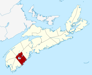
Queens County is a county in the Canadian province of Nova Scotia.

Westmorland is a historic county in north-west England. It formed an administrative county between 1889 and 1974, after which the whole county was administered by the new administrative and ceremonial county of Cumbria. The people of Westmorland are known as Westmerians. In April 2023, it is planned that local government in Cumbria will be reorganised into two unitary authorities, one of which is to be named Westmorland and Furness and would cover most of the historic county along with parts of historic Yorkshire, Lancashire and Cumberland.
A census-designated place (CDP) is a concentration of population defined by the United States Census Bureau for statistical purposes only. CDPs have been used in each decennial census since 1980 as the counterparts of incorporated places, such as self-governing cities, towns, and villages, for the purposes of gathering and correlating statistical data. CDPs are populated areas that generally include one officially designated but currently unincorporated community, for which the CDP is named, plus surrounding inhabited countryside of varying dimensions and, occasionally, other, smaller unincorporated communities as well. CDPs include small rural communities, edge cities, colonias located along the Mexico–United States border, and unincorporated resort and retirement communities and their environs.

Stantonbury is a district and civil parish of Milton Keynes, Buckinghamshire, England. The toponym Stanton is derived from an Old English term for "stone-built farmstead" and the bury element from the French family Barri who held it in 1235. The original Stantonbury is a deserted medieval village now known as Stanton Low; the Stantonbury name has been reused for the modern district at the heart of the civil parish.

Selkirkshire or the County of Selkirk is a historic county and registration county of Scotland. It borders Peeblesshire to the west, Midlothian to the north, Roxburghshire to the east, and Dumfriesshire to the south. It derives its name from its county town, the Royal burgh of Selkirk.
Atherton is a town in the Metropolitan Borough of Wigan, in Greater Manchester, England and historically a part of Lancashire. The town, including Hindsford, Howe Bridge and Hag Fold, is 5 miles (8.0 km) east of Wigan, 2 miles (3.2 km) north of Leigh, and 10+3⁄4 miles (17.3 km) northwest of Manchester. From the 17th century, for about 300 years, Atherton was known as Chowbent, which was frequently shortened to Bent, the town's old nickname.

Austerson is a civil parish in the unitary authority of Cheshire East and the ceremonial county of Cheshire, England, lying immediately south of the town of Nantwich and north of the village of Audlem. Predominantly rural with scattered farms, the civil parish includes the small settlement of Old Hall Austerson at SJ656493, about two miles south of Nantwich centre. In 2001, the total population was a little under 150, increasing to 194 at the 2011 Census. Nearby villages include Broomhall Green, Hack Green, Hankelow, Sound Heath and Stapeley.

Bulkeley is a village and civil parish in the unitary authority of Cheshire East and the ceremonial county of Cheshire, England. The village is on the A534 road, 9 miles (14 km) west of Nantwich. In the 2011 census it had a population of 239.

The town is the basic unit of local government and local division of state authority in the six New England states. Most other U.S. states lack a direct counterpart to the New England town. New England towns overlay the entire area of a state, similar to civil townships in other states where they exist, but they are fully functioning municipal corporations, possessing powers similar to cities in other states. New Jersey's system of equally powerful townships, boroughs, towns, and cities is the system which is most similar to that of New England. New England towns are often governed by a town meeting legislative body. The great majority of municipal corporations in New England are based on the town model; there, statutory forms based on the concept of a compact populated place are uncommon, though elsewhere in the U.S. they are prevalent. County government in New England states is typically weak at best, and in some states nonexistent. Connecticut, for example, has no county governments, nor does Rhode Island. Both of those states retain counties only as geographic subdivisions with no governmental authority, while Massachusetts has abolished eight of fourteen county governments so far. Counties serve mostly as dividing lines for the states' judicial systems and some other state services in the southern New England states, while providing limited services in the three northern New England states.

Wirswall is a village and civil parish in the unitary authority of Cheshire East and the ceremonial county of Cheshire, England, located at SJ544441 near the Shropshire border, around 1½ miles north of Whitchurch. The historical township had an area of 973 acres (3.94 km2). The civil parish also includes the settlements of Bradeley Green, Wicksted and part of Willey Moor.

Staining is a village and civil parish in Lancashire, England, on the Fylde coast close to the seaside resorts of Blackpool and Lytham St Annes, and the market town of Poulton-le-Fylde. At the 2011 Census, it had a population of 2,290. Historically, the village was part of the township of Hardhorn-with-Newton. Now the hamlet of Newton is part of the civil parish of Staining; Hardhorn belongs to Poulton-le-Fylde.
Wanham is a hamlet in northern Alberta, Canada within Birch Hills County. It is located 29 km (18 mi) east of Rycroft along Highway 49 and approximately 106 km (66 mi) north of Grande Prairie, in the farmlands of Peace River Country. Saddle River, a tributary of Peace River, flows immediately north of the community. The origin of the name Wanham could have come from Wanham in England.

Chowley is a hamlet and civil parish in the Borough of Cheshire West and Chester and the ceremonial county of Cheshire, England. It is approximately 9.5 miles (15.3 km) south east of Chester and about 1.3 miles (2.1 km) south west of Tattenhall.

Greater London is an administrative area in England governed by the Greater London Authority, and a ceremonial county that covers the bulk of the same area, with the exception of the City of London, which forms a separate ceremonial county. The administrative area, which has the same extent as the London Region, is organised into 33 local government districts: the 32 London boroughs and the City of London. The Greater London Authority, based in Newham as of the start of 2022, is responsible for strategic local government across the area and consists of the Mayor of London and the London Assembly.
References
- 1971 census