Related Research Articles

A borough is an administrative division in various English-speaking countries. In principle, the term borough designates a self-governing walled town, although in practice, official use of the term varies widely.

In the United States, a county or county equivalent is an administrative or political subdivision of a state that consists of a geographic region with specific boundaries and usually some level of governmental authority. The term "county" is used in 48 states, while Louisiana and Alaska have functionally equivalent subdivisions called parishes and boroughs, respectively. The specific governmental powers of counties vary widely between the states, with many providing some level of services to civil townships, municipalities, and unincorporated areas. Certain municipalities are in multiple counties; New York City is uniquely partitioned into five counties, referred to at the city government level as boroughs. Some municipalities have consolidated with their county government to form consolidated city-counties, or have been legally separated from counties altogether to form independent cities. Conversely, those counties in Connecticut, Rhode Island, eight of Massachusetts's 14 counties, and Alaska's Unorganized Borough have no government power, existing only as geographic distinctions.

Westmorland (, formerly also spelt Westmoreland; is a historic county in North West England spanning the southern Lake District and the northern Dales. It had an administrative function from the 12th century until 1974. Between 1974 and 2023 Westmorland lay within the administrative county of Cumbria. In April 2023, Cumbria County Council will be abolished and replaced with two unitary authorities, one of which, Westmorland and Furness, will cover all of Westmorland, thereby restoring the Westmorland name to a top-tier administrative entity. The people of Westmorland are known as Westmerians.

The County of London was a county of England from 1889 to 1965, corresponding to the area known today as Inner London. It was created as part of the general introduction of elected county government in England, by way of the Local Government Act 1888. The Act created an administrative County of London, which included within its territory the City of London. However, the City of London and the County of London formed separate ceremonial counties for "non-administrative" purposes. The local authority for the county was the London County Council (LCC), which initially performed only a limited range of functions, but gained further powers during its 76-year existence. The LCC provided very few services within the City of London, where the ancient Corporation monopolised local governance. In 1900, the lower-tier civil parishes and district boards were replaced with 28 new metropolitan boroughs. The territory of the county was 74,903 acres (303.12 km2) in 1961. During its existence, there was a long-term decline in population as more residents moved into the outer suburbs; there were periodic reviews of the local government structures in the greater London area and several failed attempts to expand the boundaries of the county. In 1965, the London Government Act 1963 replaced the county with the much larger Greater London administrative area.

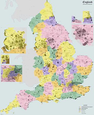
The counties and areas for the purposes of the lieutenancies, also referred to as the lieutenancy areas of England and informally known as ceremonial counties, are areas of England to which lords-lieutenant are appointed. Legally, the areas in England, as well as in Wales and Scotland, are defined by the Lieutenancies Act 1997 as "counties and areas for the purposes of the lieutenancies in Great Britain", in contrast to the areas used for local government. They are also informally known as "geographic counties", to distinguish them from other types of counties of England.
County borough is a term introduced in 1889 in the United Kingdom of Great Britain and Ireland, to refer to a borough or a city independent of county council control, similar to the unitary authorities created since the 1990s. An equivalent term used in Scotland was a county of city. They were abolished by the Local Government Act 1972 in England and Wales, but continue in use for lieutenancy and shrievalty in Northern Ireland. In the Republic of Ireland they remain in existence but have been renamed cities under the provisions of the Local Government Act 2001. The Local Government (Wales) Act 1994 re-introduced the term for certain "principal areas" in Wales. Scotland did not have county boroughs but instead had counties of cities. These were abolished on 16 May 1975. All four Scottish cities of the time—Aberdeen, Dundee, Edinburgh, and Glasgow—were included in this category. There was an additional category of large burgh in the Scottish system, which were responsible for all services apart from police, education and fire.
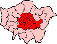
Inner London is the name for the group of London boroughs which form the interior part of Greater London and are surrounded by Outer London. With its origins in the bills of mortality, it became fixed as an area for statistics in 1847 and was used as an area of local government from 1855 to 1965 principally as the County of London or earlier as the Metropolitan Board of Works Area (metropolis). It now has two common definitions. The first is the statutory definition delineated in the London Government Act 1963, coming into force on 1 April 1965, comprising twelve Inner London boroughs and almost identical to the County of London that was abolished at the same time. The second is the definition used by the Office for National Statistics comprising eleven of the statutory Inner London boroughs and two of the statutory Outer London boroughs, and the City of London.

Outer London is the name for the group of London boroughs that form a ring around Inner London. Together, the inner and outer boroughs form London, the capital city of the United Kingdom.

Cambridgeshire and Isle of Ely was, from 1965 to 1974, an administrative and geographical county in East Anglia in the United Kingdom. In 1974 it became part of an enlarged Cambridgeshire.
An electoral division is a legally defined administrative area in the Republic of Ireland, generally comprising multiple townlands, and formerly a subdivision of urban and rural districts. Until 1996, EDs were known as district electoral divisions in the 29 county council areas and wards in the five county boroughs. Until 1972, DEDs also existed in Northern Ireland. The predecessor poor law electoral divisions were introduced throughout the island of Ireland in the 1830s. The divisions were used as local-government electoral areas until 1919 in what is now the Republic and until 1972 in Northern Ireland.

The Borough of Dún Laoghaire was a borough on the southern coast of County Dublin, Ireland from 1930 to 1994. Its local authority was the Corporation of Dún Laoghaire.

Northern Ireland is divided into six counties, namely: Antrim, Armagh, Down, Fermanagh, Londonderry and Tyrone. Six largely rural administrative counties based on these were among the eight primary local government areas of Northern Ireland from its 1921 creation until 1973. The other two local government areas were the urban county boroughs of Derry and Belfast.
The history of local government in Wales in a recognisably modern form emerged during the late 19th century. Administrative counties and county boroughs were first established in Wales in 1889. Urban and rural districts were formed in 1894. These were replaced in 1974 by a two-tier authority system across the country comprising eight counties and, within them, thirty-seven districts. This system was itself replaced by the introduction of 22 single-tier authorities in 1996.
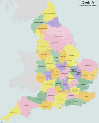
Administrative counties were subnational divisions of England used for local government from 1889 to 1974. They were created by the Local Government Act 1888, which established an elected county council for each area. Some geographically large historic counties were divided into several administrative counties, each with its own county council. The administrative counties operated until 1974, when they were replaced by a system of metropolitan and non-metropolitan counties under the Local Government Act 1972.

Teesside was, from 1968 to 1974, a local government district in northern England. It comprised a conurbation that spanned both sides of the River Tees from which it took its name. Teesside had the status of a county borough and was independent of the county councils of the North Riding of Yorkshire, and County Durham. The Lord Lieutenant of the North Riding of Yorkshire represented the whole of Teesside, including those areas north of the Tees which were in Durham.
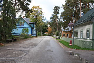
Võsu is a small borough in Lääne-Viru County, in Haljala Parish, in Estonia. It was the administrative centre of Vihula Parish. As of 2011 Census, the settlement's population was 334.

Greater London is an administrative area in England governed by the Greater London Authority. It is organised into 33 local government districts: the 32 London boroughs and the City of London. Greater London is one of the regions of England, also known as the London Region. The Greater London Authority, based in Newham as of the start of 2022, is responsible for strategic local government across the area and consists of the Mayor of London and the London Assembly.
References
- 1971 census