Highway names | |
---|---|
Interstates | Interstate X (I-X) |
US Highways | U.S. Highway X (US X) |
State | Trunk Highway X (MN X or TH X) |
County State-Aid Highways: | County State-Aid Highway X (CSAH X) |
County Roads: | County Road X (CR X) |
System links | |
The following is a list of county-maintained roads in Cass County, Minnesota, United States. Some of the routes included in this list are also county-state-aid-highways (CSAH.)
Number | Length (mi) | Length (km) | Southern or western terminus | Northern or eastern terminus | Local names | Formed | Removed | Notes |
---|---|---|---|---|---|---|---|---|
CSAH 1 | — | — | MN 210 in Sylvan Township | Ridge Avenue in Pine River | — | — | Southern segment | |
CSAH 1 | — | — | 5th Street in Pine River | Crow Wing County line | 24th Street | — | — | Eastern segment |
CSAH 2 | — | — | 84th Avenue (County 111) in Ansel Township | 1st Street in Pine River | 24th Street | — | — | |
CSAH 3 | — | — | Itasca County line | Itasca County line | 72nd Avenue; 124th Street | — | — | |
CSAH 4 | — | — | County 8 in Gould Township | Airport Drive in Remer | 102nd Street | — | — | |
CSAH 5 | — | — | MN 371 in Hackensack | MN 84 in Longville | — | — | ||
CSAH 6 | — | — | Hubbard County line | MN 371 in Birch Lake Township | — | — | ||
CSAH 7 | — | — | MN 84 in Longville | MN 6 in Remer Township | 44th Street | — | — | |
CSAH 8 | — | — | MN 200 in Kego Township | US 2 in Unorganized Cass County | — | — | ||
CSAH 9 | — | — | US 2 in Unorganized Cass County | Itasca County line | Winnie Dam Road | — | — | |
CSAH 10 | — | — | US 2 in Unorganized Cass County | Beltrami County line | Scenic Highway | — | — | |
CSAH 11 | — | — | County 5 in Woodrow Township | MN 84 in Woodrow Township | — | — | ||
CSAH 12 | — | — | Hubbard County line | MN 200 and MN 371 in Walker | 10th Street | — | — | |
CSAH 13 | — | — | MN 200 in Turtle Lake Township | Cedar Point Road in Shingobee Township | Onigum Road | — | — | |
CSAH 14 | — | — | County 2 in Pine River Township | Leatherwood Lane in Pine River | Barclay Avenue | — | — | |
CSAH 15 | — | — | County 1 in Fairview Township | County 77 in Fairview Township | 100th Street | — | — | |
CSAH 17 | — | — | County 1 in Maple Township | Crow Wing County line | 56th Street | — | — | |
CSAH 18 | — | — | MN 210 in Sylvan Township | County 77 in East Gull Lake | — | — | ||
CSAH 19 | — | — | Wadena County line | MN 64 in McKinley Township | 12th Street | — | — | |
CSAH 20 | — | — | Wadena County line | MN 64 in Ansel Township | — | — | ||
CSAH 21 | — | — | Hubbard County line | MN 371 in Wilkinson Township | 136th Street | — | — | |
CSAH 22 | — | — | Hubbard County line | 61st Avenue (County 147) in Pike Bay Township | 156th Street | — | — | |
CSAH 23 | — | — | Wadena County line | MN 64 in Poplar Township | 60th Street | — | — | |
CSAH 24 | — | — | MN 64 in Poplar Township | County 1 in Maple Township | 62nd Street; 64th Street | — | — | |
CSAH 25 | — | — | 64th Street (County 24) in Moose Lake Township | MN 371 in Pine River Township | 57th Avenue; 58th Street; 55th Avenue; 52nd Street; 53rd Avenue; 48th Street; 56th Avenue; 36th Street; 54th Avenue; 32nd Street; 48th Avenue; 10th Street; 46th Avenue; 8th Street | — | — | |
CSAH 26 | — | — | 48th Street (County 28) in Walden Township | 24th Street (County 2) in Walden Township | 40th Avenue | — | — | |
CSAH 27 | — | — | 46th Avenue (County 25) in Pine River Township | MN 87 in Bull Moose Township | 8th Street; 48th Avenue | — | — | |
CSAH 28 | — | — | 53rd Avenue (County 25) in Moose Lake Township | County 1 in Maple Township | 48th Street | — | — | |
CSAH 29 | — | — | County 1 in Homebrook Township | Crow Wing County line | 76th Street | — | — | |
CSAH 30 | — | — | Wadena County line | MN 64 in Byron Township | 84th Street | — | — | |
CSAH 31 | — | — | MN 210 in May Township | 3rd Street in Pillager | 51st Avenue; 132nd Street; Hazel Avenue | — | — | |
CSAH 32 | — | — | 120th Street (County 33) in Becker Township | 95th Avenue (County 67) in Becker Township | — | — | ||
CSAH 33 | — | — | Todd County line | MN 64 in May Township | 120th Street | — | — | |
CSAH 34 | — | — | MN 64 in May Township | County 1 in Fairview Township | 112th Street | — | — | |
CSAH 35 | — | — | MN 210 in May Township | MN 64 in Meadow Brook Township | 57th Avenue; 92nd Street | — | — | |
CSAH 36 | — | — | MN 210 in Sylvan Township | MN 210 in Sylvan Township | 21st Avenue; 136th Street; 11th Avenue | — | — | |
CSAH 38 | — | — | Hubbard County line | MN 200 and MN 371 in Shingobee Township | — | — | ||
CSAH 39 | — | — | MN 200 in Kego Township | MN 200 in Kego Township | 72nd Street | — | — | |
CSAH 40 | — | — | Hubbard County line | MN 371 in Hackensack | — | — | ||
CSAH 41 | — | — | MN 87 in Deerfield Township | County 40 in Hiram Township | 68th Avenue; 16th Street | — | — | |
CSAH 42 | — | — | Murray Avenue in Pine River | MN 87 in Powers Township | 1st Street; 24th Avenue; 8th Street; 28th Avenue | — | — | |
CSAH 43 | — | — | MN 84 in Barclay Township | County 49 in Ponto Lake Township | 12th Street; 12th Avenue | — | — | |
CSAH 44 | — | — | MN 371 in Wilson Township | MN 84 in Barclay Township | 16th Avenue | — | — | |
CSAH 45 | — | — | MN 371 in Birch Lake Township | County 5 in Birch Lake Township | — | — | ||
CSAH 46 | — | — | County 5 in Birch Lake Township | MN 84 in Ponto Lake Township | 21st Street | — | — | |
CSAH 47 | — | — | MN 84 in Woodrow Township | Old Grade Trail (County 54) in Wabedo Township | 24th Street | — | — | |
CSAH 48 | — | — | Crow Wing County line | 8th Avenue (County 174) in Blind Lake Township | Division Street; Central Avenue; 4th Street; Short Cut Road; 8th Street | — | — | Western segment |
CSAH 48 | — | — | County 55 in Trelipe Township | MN 6 in Crooked Lake Township | 12th Street; Lake Washburn Road | — | — | Eastern segment |
CSAH 49 | — | — | MN 84 in Ponto Lake Township | 8th Avenue (County 174) in Blind Lake Township | 12th Street | — | — | |
CSAH 50 | — | — | MN 371 in Turtle Lake Township | MN 34 in Shingobee Township | — | — | ||
CSAH 52 | — | — | County 4 in Slater Township | County 65 in Salem Township | — | — | ||
CSAH 53 | — | — | MN 200 in Inguadona Township | County 4 in Slater Township | Tobique Road | — | — | |
CSAH 54 | — | — | 24th Street (County 47) in Wabedo Township | County 7 in Wabedo Township | — | — | ||
CSAH 55 | — | — | 12th Street (County 48/County 160) in Trelipe Township | 44th Street (County 7) in Trelipe Township | — | — | ||
CSAH 57 | — | — | Winding Road (County 68) in Smoky Hollow Township | MN 200 in Lima Township | 42nd Street | — | — | |
CSAH 58 | — | — | MN 6 in Crooked Lake Township | Aitkin County line | Warbler Road | — | — | |
CSAH 60 | — | — | 69th Avenue (County 75) in Pike Bay Township | US 2 in Cass Lake | 164th Street; 61st Avenue | — | — | |
CSAH 61 | — | — | Hubbard County line | MN 371 in Leech Lake Township | 108th Street | — | — | |
CSAH 62 | — | — | Hubbard County line | MN 371 in Leech Lake Township | 100th Street | — | — | |
CSAH 63 | — | — | 102nd Street (County 4) in Boy River Township | County 8 in Gould Township | — | — | ||
CSAH 65 | — | — | County 4 in Salem Township | Itasca County line | — | — | ||
CSAH 66 | — | — | 72nd Avenue in Wilkinson Township | MN 371 in Wilkinson Township | 122nd Street | — | — | |
CSAH 67 | — | — | Todd County line | 84th Street (County 30) in Byron Township | 95th Avenue | — | — | |
CSAH 68 | — | — | Aitkin County line | 42nd Street (County 57) in Smoky Hollow Township | Winding Road | — | — | |
CSAH 69 | — | — | North Steamboat Lake Drive (County 141) in Wilkinson Township | 156th Street (County 22) in Pike Bay Township | 72nd Avenue; 144th Street; 73rd Avenue | — | — | |
CSAH 70 | — | — | County 77 in East Gull Lake | Pike Bay Road in East Gull Lake | East Gull Lake Drive | — | — | |
CSAH 71 | — | — | County 6 in Hiram Township | County 50 in Shingobee Township | — | — | ||
CSAH 72 | — | — | Onigum Road (County 13) in Shingobee Township | Dead end in Turtle Lake Township | Pine Point Road | — | — | |
CSAH 73 | — | — | Sugar Point Drive (County 136) in Gould Township | County 8 in Gould Township | — | — | ||
CSAH 74 | — | — | County 65 in Torrey Township | 124th Street (County 3) in Unorganized Cass County | 88th Avenue | — | — | |
CSAH 75 | — | — | US 2 in Pike Bay Township | Beltrami County line | 69th Avenue | — | — | |
CSAH 77 | — | — | Crow Wing County line | Crow Wing County line | Pine Beach Road; Interlachen Road | — | — | |
CSAH 78 | — | — | Interlachen Road (County 77) in Lake Shore | 76th Street (County 29) in Lake Shore | — | — | ||
CSAH 79 | — | — | MN 84 in Ponto Lake Township | 12th Avenue (County 43) in Ponto Lake Township | Division Street | — | — | |
CR 87 | — | — | Poncelet Road in Shingobee Township | County 12 in Shingobee Township | 73rd Avenue | — | — | |
CSAH 91 | — | — | Scenic Highway (County 10) in Unorganized Cass County | Beltrami County line | — | — | Western segment | |
CSAH 91 | — | — | Beltrami County line | US 2 in Unorganized Cass County | West Winnie Road | — | — | Eastern segment |
CR 102 | — | — | MN 210 in May Township | 57th Avenue (County 35) in May Township | 61st Avenue; 96th Street | — | — | |
CR 103 | — | — | 92nd Street (County 35) in Meadow Brook Township | 76th Street (County 103) in Meadow Brook Township | 66th Avenue; 88th Street; 65th Avenue | — | — | Southern segment |
CR 103 | — | — | MN 64 in Meadow Brook Township | 57th Avenue in Meadow Brook Township | 76th Street | — | — | Northern segment |
CR 104 | — | — | 112th Street (County 34) in May Township | 104th Street in May Township | 49th Avenue | — | — | |
CR 105 | — | — | Gull Lake Lane in East Gull Lake | Crow Wing County line | Gull Lake Dam Road | — | — | |
CR 106 | — | — | 120th Street (County 33) in Becker Township | 72nd Street in Byron Township | 79th Avenue | — | — | |
CR 107 | — | — | County 1 in Homebrook Township | 21st Avenue (County 107) in Homebrook Township | 88th Street; 29th Avenue; 92nd Street; 25th Avenue; 91st Street | — | — | Western segment |
CR 107 | — | — | 100th Street (County 15) in Fairview Township | County 78 in Lake Shore | Agate Lake Drive; 21st Avenue | — | — | Eastern segment |
CR 108 | — | — | 37th Avenue in Homebrook Township | County 1 in Homebrook Township | 76th Street | — | — | |
CR 109 | — | — | MN 64 in Byron Township | 64th Street (County 24) in Moose Lake Township | 71st Avenue | — | — | |
CR 110 | — | — | 60th Street (County 23) in Poplar Township | County 20 in Ansel Township | Cass Line Road | — | — | |
CR 111 | — | — | 16th Street in McKinley Township | 12th Street (County 19) in McKinley Township | 96th Avenue | — | — | Western segment |
CR 111 | — | — | County 20 in Ansel Township | 12th Street (County 19) in McKinley Township | 84th Avenue | — | — | Eastern segment |
CR 112 | — | — | MN 64 in McKinley Township | 72nd Avenue (County 112) in McKinley Township | 4th Street | — | — | Western segment |
CR 112 | — | — | 24th Street (County 2) in McKinley Township | MN 87 in McKinley Township | 72nd Avenue | — | — | Eastern segment |
CR 114 | — | — | County 1 in Walden Township | County 17 in Loon Lake Township | 48th Street; 21st Avenue; 52nd Street | — | — | |
CR 115 | — | — | County 1 in Wilson Township | Crow Wing County line | 44th Street | — | — | Southern segment |
CR 115 | — | — | 44th Street (County 115) in Wilson Township | MN 371 in Wilson Township | 16th Avenue | — | — | Northern segment |
CR 116 | — | — | MN 87 in Bull Moose Township | 1st Avenue in Powers Township | Pine Mountain Lake Road; 45th Avenue | — | — | |
CR 117 | — | — | MN 371 in Powers Township | 40th Avenue (County 117) in Powers Township | 16th Street | — | — | Western segment |
CR 117 | — | — | MN 87 and MN 371 in Powers Township | County 45 in Powers Township | 4th Street; 40th Avenue; 20th Street; 38th Avenue | — | — | Eastern segment |
CR 118 | — | — | 28th Avenue (County 42) in Powers Township | MN 84 in Ponto Lake Township | Division Street | — | — | |
CR 119 | — | — | MN 87 in Ponto Lake Township | County 46 in Ponto Lake Township | 16th Avenue; 16th Street; 12th Avenue; 21st Street | — | — | |
CR 120 | — | — | 24th Street (County 47) in Wabedo Township | County 54 in Wabedo Township | Wabedo Pass Road | — | — | |
CR 121 | — | — | County 5 in Birch Lake Township | North Stony Drive in Birch Lake Township | 36th Avenue | — | — | |
CR 122 | — | — | County 5 in Woodrow Township | Bluebird Trail in Birch Lake Township | 23rd Avenue; Lake Drive | — | — | |
CR 124 | — | — | MN 200 in Turtle Lake Township | MN 200 in Pine Lake Township | 36th Avenue; 64th Street; 24th Avenue | — | — | |
CR 125 | — | — | County 5 in Kego Township | MN 200 in Kego Township | — | — | ||
CR 126 | — | — | MN 84 in Kego Township | MN 200 in Kego Township | — | — | ||
CR 127 | — | — | County 39 in Kego Township | County 8 in Boy Lake Township | 72nd Street | — | — | |
CR 128 | — | — | MN 200 in Kego Township | 20th Avenue (County 157) in Boy Lake Township | 24th Avenue; 79th Street | — | — | |
CR 129 | — | — | County 7 in Trelipe Township | MN 200 in Inguadona Township | 32nd Avenue; 64th Street; 40th Avenue | — | — | |
CR 130 | — | — | Lakeside Park Drive in Slater Township | 64th Avenue (County 130) in Slater Township | 72nd Street | — | — | Western segment |
CR 130 | — | — | MN 200 in Remer Township | County 4 in Slater Township | 64th Avenue | — | — | Eastern segment |
CR 132 | — | — | MN 200 in Lima Township | 84th Avenue in Lima Township | 64th Street | — | — | |
CR 133 | — | — | Dead end in Remer Township | MN 200 in Lima Township | 52nd Street; 76th Avenue | — | — | |
CR 135 | — | — | County 63 in Boy River Township | County 65 in Salem Township | 108th Street | — | — | |
CR 136 | — | — | Dead end in Gould Lake Township | County 73 in Gould Township | Sugar Point Drive | — | — | Western segment |
CR 136 | — | — | Point Lane in Gould Lake Township | County 73 in Gould Township | Battle Point Drive | — | — | Central segment |
CR 136 | — | — | Battle Point Drive (County 136) in Gould Lake Township | Pointview Drive in Gould Township | 101st Street | — | — | Eastern segment |
CR 137 | — | — | Dead end in Torrey Township | County 65 in Torrey Township | 82nd Avenue | — | — | |
CR 139 | — | — | 72nd Avenue (County 3/County 158) in Unorganized Cass County | 72nd Avenue (County 3) in Unorganized Cass County | 124th Street; Mud Lake Road | — | — | |
CR 141 | — | — | Hubbard County line | 68th Avenue (County 143) in Wilkinson Township | North Steamboat Lake Drive | — | — | Western segment |
CR 141 | — | — | MN 371 in Wilkinson Township | 63rd Avenue in Wilkinson Township | 131st Street | — | — | Eastern segment |
CR 142 | — | — | MN 371 in Leech Lake Township | MN 371 in Leech Lake Township | Steamboat Loop | — | — | |
CR 143 | — | — | 130th Street in Wilkinson Township | 61st Avenue (County 146) in Pike Bay Township | 68th Avenue; 144th Street | — | — | |
CR 144 | — | — | Dead end in Wilkinson Township | MN 371 in Wilkinson Township | 56th Avenue; 136th Street | — | — | Southern segment |
CR 144 | — | — | 136th Street (County 144) in Wilkinson Township | 61st Avenue (County 146) in Pike Bay Township | 60th Avenue; 144th Street | — | — | Northern segment |
CR 145 | — | — | Hubbard County line | 60th Avenue (County 144) in Wilkinson Township | 140th Street | — | — | |
CR 146 | — | — | 144th Street (County 143/County 144) in Pike Bay Township | 61st Avenue (County 147) in Pike Bay Township | 61st Avenue; 148th Street; 65th Avenue; 152nd Street | — | — | |
CR 147 | — | — | Bayview Loop in Pike Bay Township | 3rd Street in Cass Lake | 61st Avenue | — | — | |
CR 149 | — | — | US 2 in Pike Bay Township | Beltrami County line | 65th Avenue | — | — | |
CR 150 | — | — | Hubbard County line | 69th Avenue (County 75) in Pike Bay Township | Little Wolf Road | — | — | |
CR 151 | — | — | US 2 in Pike Bay Township | MN 371 in Cass Lake | 160th Street | — | — | |
CR 153 | — | — | Onigum Road (County 13) in Turtle Lake Township | Hawthorne Trail in Turtle Lake Township | — | — | ||
CR 154 | — | — | County 63 in Gould Township | Ash Street in Federal Dam | 24th Avenue; 116th Street; 18th Avenue; 120th Street | — | — | |
CR 155 | — | — | Crow Wing County line | Lake Washburn Road (County 48) in Crooked Lake Township | — | — | ||
CR 156 | — | — | 79th Avenue (County 106) in Byron Township | MN 64 in Byron Township | 80th Street | — | — | |
CR 157 | — | — | MN 200 in Kego Township | 96th Street (County 172) in Boy Lake Township | 20th Avenue; 88th Street; 20th Avenue | — | — | |
CR 158 | — | — | County 65 in Salem Township | 124th Street (County 3/County 139) in Unorganized Cass County | 72nd Avenue | — | — | |
CR 160 | — | — | 8th Avenue (County 174) in Blind Lake Township | County 55 in Trelipe Township | 8th Street; 12th Street | — | — | |
CR 161 | — | — | MN 6 in Thunder Lake Township | MN 6 in Thunder Lake Township | Big Rice Lake Road | — | — | Western segment |
CR 161 | — | — | Big Rice Lake Road (County 161) in Thunder Lake Township | County 57 in Smoky Hollow Township | 44th Street; 68th Avenue; 42nd Street | — | — | Eastern segment |
CR 163 | — | — | MN 200 and MN 371 in Shingobee Township | MN 200 and MN 371 in Walker | Front Street | — | — | |
CR 168 | — | — | 17th Avenue in Loon Lake Township | Crow Wing County line | 64th Street | — | — | |
CR 171 | — | — | 40th Avenue (County 26) in Walden Township | County 1 in Walden Township | 32nd Street; 32nd Avenue; 29th Street | — | — | |
CR 172 | — | — | Woodchuck Lane in Rogers Township | County 8 in Boy Lake Township | Boy Lake Drive; 96th Street | — | — | |
CR 173 | — | — | Dead end in Woodrow Township | County 46 in Woodrow Township | Nature Center Drive | — | — | |
CR 174 | — | — | 8th Street (County 48/County 160) in Blind Lake Township | 24th Street (County 47) in Blind Lake Township | 8th Avenue; 16th Street; Deer Creek Road | — | — | |
CR 176 | — | — | Hubbard County line | 56th Avenue (County Road 146) in Pike Bay | 148th Street | — | — | |
CSAH 206 | — | — | MN 371 in Cass Lake | US 2 in Cass Lake | 2nd Street | — | — | |
In the United States, a metropolitan statistical area (MSA) is a geographical region with a relatively high population density at its core and close economic ties throughout the area. Such regions are neither legally incorporated as a city or town would be, nor are they legal administrative divisions like counties or separate entities such as states; because of this, the precise definition of any given metropolitan area can vary with the source. The statistical criteria for a standard metropolitan area were defined in 1949 and redefined as metropolitan statistical area in 1983. A typical metropolitan area is centered on a single large city that wields substantial influence over the region. However, some metropolitan areas contain more than one large city with no single municipality holding a substantially dominant position. MSAs are defined by the U.S. Office of Management and Budget (OMB) and used by the Census Bureau and other federal government agencies for statistical purposes.
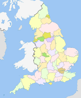
The counties of England are areas used for different purposes, which include administrative, geographical, cultural and political demarcation. The term 'county' is defined in several ways and can apply to similar or the same areas used by each of these demarcation structures. These different types of county each have a more formal name but are commonly referred to just as 'counties'. The current arrangement is the result of incremental reform.
New York most commonly refers to:
The English Football League Championship is the highest division of the English Football League (EFL) and second-highest overall in the English football league system after the Premier League. The league is contested by 24 clubs.
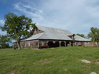
This is a list of properties and historic districts in Oklahoma that are designated on the National Register of Historic Places. Listings are distributed across all of Oklahoma's 77 counties.
This is a list of properties and historic districts in Iowa that are listed on the National Register of Historic Places. There are listings in all of Iowa's 99 counties, adding up to over 2,300 total.
This is a list of properties and historic districts in Montana that are listed on the National Register of Historic Places. The state's more than 1,100 listings are distributed across all of its 56 counties.
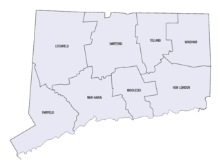
This is a list of properties and districts listed on the National Register of Historic Places in Connecticut. There are more than 1,500 listed sites in Connecticut. All 8 counties in Connecticut have listings on the National Register.
This is a list of properties and districts in Indiana that are listed on the National Register of Historic Places. There are over 1,900 in total. Of these, 39 are National Historic Landmarks. Each of Indiana's 92 counties has at least two listings.
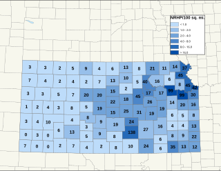
There are over 1,400 buildings, sites, districts, and objects in Kansas listed on the National Register of Historic Places in Kansas. NRHP listings appear in 101 of the state's 105 counties.
This is a list of properties and districts in New Mexico that are on the National Register of Historic Places. There are more than 1,100 listings. Of these, 46 are National Historic Landmarks. There are listings in each of the state's 33 counties.
This is a list of properties and districts listed on the National Register of Historic Places in Rhode Island. As of May 29, 2015, there are more than 750 listed sites in Rhode Island. All 5 of the counties in Rhode Island have listings on the National Register.