Barclay Township, Cass County, Minnesota

Last updated

Barclay Township, Minnesota
USA Minnesota location map.svg
Red pog.svg
Barclay Township, Minnesota
Location within the state of Minnesota
Usa edcp location map.svg
Red pog.svg
Barclay Township, Minnesota
Barclay Township, Minnesota (the United States)
Coordinates: 46°45′31″N94°22′41″W / 46.75861°N 94.37806°W / 46.75861; -94.37806
Country United States
State Minnesota
County Cass
Area
  Total15.0 sq mi (38.9 km2)
  Land14.0 sq mi (36.2 km2)
  Water1.1 sq mi (2.7 km2)
Elevation
1,319 ft (402 m)
Population
 (2000)
  Total516
  Density36.9/sq mi (14.3/km2)
Time zone UTC-6 (Central (CST))
  Summer (DST) UTC-5 (CDT)
ZIP code
56474
Area code 218
FIPS code 27-03538 [1]
GNIS feature ID0663505 [2]

Barclay Township is a township in Cass County, Minnesota, United States. As of the 2000 census, its population was 516. [3] Barclay Township was named for an early settler. [4]

Contents

Geography

According to the United States Census Bureau, Barclay Township covers an area of 15.03 square miles (38.92 square kilometers); of this, 1.06 square miles (2.75 square kilometers) or 7.07 percent is water.

The entire city of Chickamaw Beach and the north quarter of the city of Pine River are located within Barclay Township geographically but are separate entities.

Adjacent townships

Major highway

Lakes

School districts

Political districts

Demographics

As of the census [1] of 2000, there were 516 people, 212 households, and 146 families residing in the township. The population density was 36.9 inhabitants per square mile (14.2/km2). There were 285 housing units at an average density of 20.4 per square mile (7.9/km2). The racial makeup of the township was 96.71% White, 0.19% African American, 0.97% Native American, 0.58% Asian, and 1.55% from two or more races. Hispanic or Latino of any race were 1.94% of the population.

There were 212 households, out of which 32.1% had children under the age of 18 living with them, 58.0% were married couples living together, 4.2% had a female householder with no husband present, and 31.1% were non-families. 28.8% of all households were made up of individuals, and 14.2% had someone living alone who was 65 years of age or older. The average household size was 2.43 and the average family size was 3.00.

In the township the population was spread out, with 25.4% under the age of 18, 6.2% from 18 to 24, 25.4% from 25 to 44, 27.3% from 45 to 64, and 15.7% who were 65 years of age or older. The median age was 42 years. For every 100 females, there were 102.4 males. For every 100 females age 18 and over, there were 109.2 males.

The median income for a household in the township was $32,039, and the median income for a family was $36,058. Males had a median income of $30,972 versus $17,500 for females. The per capita income for the township was $15,215. About 2.9% of families and 8.0% of the population were below the poverty line, including 11.3% of those under age 18 and 7.4% of those age 65 or over.

Related Research Articles

<span class="mw-page-title-main">Farm Island Township, Aitkin County, Minnesota</span> Township in Minnesota, United States

Farm Island Township is a township in Aitkin County, Minnesota, United States. The population was 1,099 as of the 2010 census.

Hazelton Township is a township in Aitkin County, Minnesota, United States. The population was 844 as of the 2010 census.

Lee Township is a township in Aitkin County, Minnesota, United States. The population was 50 as of the 2010 census.

Logan Township is a township in Aitkin County, Minnesota, United States. The population was 184 as of the 2010 census.

<span class="mw-page-title-main">Millward Township, Aitkin County, Minnesota</span> Township in Minnesota, United States

Millward Township is a township in Aitkin County, Minnesota, United States. The population was 72 as of the 2010 census.

Wagner Township is a township in Aitkin County, Minnesota, United States. The population was 332 as of the 2010 census.

White Pine Township is a township in Aitkin County, Minnesota, United States. The population was 34 as of the 2010 census.

Moose Lake Township is a township in Carlton County, Minnesota, United States. The population was 956 as of the 2000 census. Moose Lake Township was named from Moose Lake and Moose Head Lake.

Twin Lakes Township is a township in Carlton County, Minnesota, United States. The population was 1,912 as of the 2000 census.

Ansel Township is a township in Cass County, Minnesota, United States. As of the 2000 census, its population was 101. Ansel was the given name of a pioneer settler.

Beulah Township is a township in Cass County, Minnesota, United States. The population was 57 as of the 2000 census. Beulah Township was named for Beulah Olds, a pioneer settler.

Bull Moose Township is a township in Cass County, Minnesota, United States. The population was 107 as of the 2000 census. This township was named after the Bull Moose Party.

Bungo Township is a township in Cass County, Minnesota, United States. The population was 111 as of the 2000 census. Bungo Township was named for the family of George Bonga.

<span class="mw-page-title-main">Crooked Lake Township, Cass County, Minnesota</span> Township in Minnesota, United States

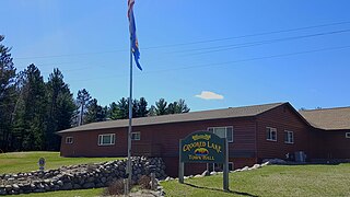
Crooked Lake Township is a township in Cass County, Minnesota, United States. The population was 498 as of the 2000 census. It is named after Roosevelt Lake, formerly known as Crooked Lake, a large lake located in this township. Crooked Lake is a translation from the Ojibwe Wewaagigamaag-zaaga'igan.

Deerfield Township is a township in Cass County, Minnesota, United States. The population was 154 as of the 2000 census. Deerfield Township was named for the large population of deer within its borders.

McKinley Township is a township in Cass County, Minnesota, United States. The population was 130 at the 2000 census. McKinley Township was named for William McKinley, 25th President of the United States.

Pine River Township is a township in Cass County, Minnesota, United States. The population was 1,061 as of the 2000 census. This township took its name from the Pine River.

Ponto Lake Township is a township in Cass County, Minnesota, United States. The population was 530 as of the 2000 census. The etymology of the name Ponto is obscure.

Powers Township is a township in Cass County, Minnesota, United States. The population was 918 at the 2000 census. Powers Township was named for Gorham Powers, a Minnesota politician who owned land there.

Wilson Township is a township in Cass County, Minnesota, United States. The population was 551 as of the 2000 census.

References

  1. 1 2 "U.S. Census website". United States Census Bureau . Retrieved January 31, 2008.
  2. "US Board on Geographic Names". United States Geological Survey. October 25, 2007. Retrieved January 31, 2008.
  3. "U.S. Census website" . Retrieved October 7, 2008.
  4. Upham, Warren (1920). Minnesota Geographic Names: Their Origin and Historic Significance. Minnesota Historical Society. p.  87.