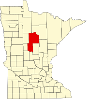
Onigum, Minnesota

Last updated

Onigum
USA Minnesota location map.svg
Red pog.svg
Onigum
Location of the community of Onigum
within Shingobee Township, Cass County
Usa edcp location map.svg
Red pog.svg
Onigum
Onigum (the United States)
Coordinates: 47°06′34″N94°32′41″W / 47.10944°N 94.54472°W / 47.10944; -94.54472
Country United States
State Minnesota
County Cass
Township Shingobee Township
Elevation
1,322 ft (403 m)
Time zone UTC-6 (Central (CST))
  Summer (DST) UTC-5 (CDT)
ZIP code
56484
Area code 218
GNIS feature ID657678 [1]

Onigum is an unincorporated community in Shingobee Township, Cass County, Minnesota, United States, near Walker, along Cass County Road 13. The name Onigum means "portage" in the Ojibwe language. [2]

History

In 1781, a large band of Ojibwe had taken control of Leech Lake and were designated by white traders as "Pillagers" or Muk-im-dua-win-in-e-wug (men who take by force). They gained a reputation as being a brave band of Ojibwe, Based on the annuity list of 1851, the band numbered about 1250 with approxitimately 300 men who were capable of bearing arms. This number only included the band which made Leech Lake their home. [3]

In 1833, Rev. Boutwell traveled north to Leech Lake to establish a mission. He arrived October 4, 1833 and his first accomplishment was to establish a school. He built a bark house for himself and within a few months he managed to complete a mud-walled cabin to protect himself from the onset of winter. After marriage and the birth of his first child, Boutwell moved back to Wisconsin. Oberlin missionaries followed but were driven away after three years.

On April 12, 1865, President Lincoln assigned Edwin Clark to be agent for the Ojibwe indians of Minnesota as well as Pembina and Turtle Mountains. Clark set out for his new assignment, determined to find a central location for the agency. After a visit to Leech Lake, he observed that it would be the most central and the most accessible point for the Indians and that the Agency should be established on the south shore of Leech Lake. A road was built to the agency and this location served as the contact point for the Indians until 1898.

The Battle of Sugar Point on October 5, 1898, focused national attention on the Agency. After the confrontation and the subsequent negotiations with the Bear Island Pillagers, the agency was moved to a new location on the peninsula about 2 1/2 miles across the water from the Old Agency. The Leech Lake Indian Agency was established by an Act of Congress, approved March 1, 1899, and $15,000 appropriated for constructing the suitable buildings and related work. [4]

The Leech Lake Agency was moved to Cass Lake, Minnesota, in 1922, but the village itself persisted and the Onigum Council was organized and chartered in 1924. In January 1926, Congressman Knutson introduced a bll to set aside 276 acres at Onigum for a village, but it was not passed. He again sponsored a bill in June 1933 to acquire the land occupied by the village as a townsite. In March 1935, the bill finally passed which established a self-governed village at Onigum. [5]

Related Research Articles

<span class="mw-page-title-main">Cass Lake, Minnesota</span> City in Minnesota, United States

Cass Lake is a city in Cass County, Minnesota, United States, located within the boundaries of the Leech Lake Indian Reservation. It is surrounded by Pike Bay Township. Cass Lake had a population of 675 in the 2020 census. It is notable as the headquarters location of Minnesota Chippewa Tribe and Leech Lake Band of Ojibwe, as well as the Chippewa National Forest.

<span class="mw-page-title-main">Walker, Minnesota</span> City in Minnesota, United States

Walker is a city in Cass County, Minnesota, United States. The population was 941 at the 2010 census. It is the county seat of Cass County.

<span class="mw-page-title-main">Ojibwe</span> Group of indigenous peoples in North America

The Ojibwe, Ojibwa, Chippewa, or Saulteaux are an Anishinaabe people in what is currently southern Canada, the northern Midwestern United States, and Northern Plains. They are Indigenous peoples of the Subarctic and Northeastern Woodlands.

<span class="mw-page-title-main">Red Lake Indian Reservation</span> Home to the federally recognized Red Lake Band of Ojibwe

The Red Lake Indian Reservation covers 1,260.3 sq mi in parts of nine counties in northwestern Minnesota, United States.

<span class="mw-page-title-main">Leech Lake</span> Lake in the state of Minnesota, United States

Leech Lake is a lake located in north central Minnesota, United States. It is southeast of Bemidji, located mainly within the Leech Lake Indian Reservation, and completely within the Chippewa National Forest. It is used as a reservoir. The lake is the third largest in Minnesota, covering 102,947.83 acres (416.6151 km2) with 195 miles (314 km) of shoreline and has a maximum depth of 156 feet (48 m).

Sandy Lake Band of Mississippi Chippewa are a historical Ojibwa tribe located in the upper Mississippi River basin, on and around Big Sandy Lake in what today is in Aitkin County, Minnesota. Though politically folded into the Mille Lacs Band of Ojibwe, thus no longer independently federally recognized, for decades, Sandy Lake Band members have been leading efforts to restore their independent Federal recognition.

<span class="mw-page-title-main">White Earth Nation</span> Native American band in Minnesota, USA

The White Earth Band of the Minnesota Chippewa Tribe, also called the White Earth Nation, is a federally recognized Native American band located in northwestern Minnesota. The band's land base is the White Earth Indian Reservation.

<span class="mw-page-title-main">Leech Lake Indian Reservation</span> Indian reservation located in north-central Minnesota

The Leech Lake Reservation is an Indian reservation located in the north-central Minnesota counties of Cass, Itasca, Beltrami, and Hubbard. The reservation forms the land base for the federally recognized Leech Lake Band of Ojibwe, one of six bands comprising the Minnesota Chippewa Tribe, organized in 1934. The Leech Lake Reservation has the second highest population of any reservation in Minnesota with White Earth Nation being the largest Minnesota Ojibwe tribe, Leech Lake Nation has a resident population of 11,388 indicated by the 2020 census.

<span class="mw-page-title-main">Leech Lake Band of Ojibwe</span>

The Leech Lake Band of Ojibwe, also known as the Leech Lake Band of Chippewa Indians or the Leech Lake Band of Minnesota Chippewa Tribe is an Ojibwe band located in Minnesota and one of six making up the Minnesota Chippewa Tribe. The band had 9,426 enrolled tribal members as of March 2014. The band's land base is the Leech Lake Indian Reservation, which includes eleven communities aggregated into three districts, as defined in the tribal constitution,

The St. Croix Chippewa Indians are a historical Band of Ojibwe located along the St. Croix River, which forms the boundary between the U.S. states of Wisconsin and Minnesota. The majority of the St. Croix Band are divided into two groups: the federally recognized St. Croix Chippewa Indians of Wisconsin, and the St. Croix Chippewa Indians of Minnesota, who are one of four constituent members forming the federally recognized Mille Lacs Band of Ojibwe. The latter is one of six bands in the federally recognized Minnesota Chippewa Tribe.

Mississippi River Band of Chippewa Indians or simply the Mississippi Chippewa, are a historical Ojibwa Band inhabiting the headwaters of the Mississippi River and its tributaries in present-day Minnesota.

Pillager Band of Chippewa Indians are a historical band of Chippewa (Ojibwe) who settled at the headwaters of the Mississippi River in present-day Minnesota. Their name "Pillagers" is a translation of Makandwewininiwag, which literally means "Pillaging Men". The French called them Pilleurs, also a translation of their name. The French and Americans adopted their autonym for their military activities as the advance guard of the Ojibwe in the invasion of the Dakota country.

<span class="mw-page-title-main">Sandy Lake Tragedy</span> 1850 tragedy in Minnesota that led to the creation of Ojibwe reservations

The Sandy Lake Tragedy was the culmination in 1850 of a series of events centered in Big Sandy Lake, Minnesota that resulted in the deaths of several hundred Lake Superior Chippewa. Officials of the Zachary Taylor Administration and Minnesota Territory sought to relocate several bands of the tribe to areas west of the Mississippi River. By changing the location for fall annuity payments, the officials intended the Chippewa to stay at the new site for the winter, hoping to lower their resistance to relocation. Due to delayed and inadequate payments of annuities and lack of promised supplies, about 400 Ojibwe, mostly men and 12% of the tribe, died of disease, starvation and cold. The outrage increased Ojibwe resistance to removal. The bands effectively gained widespread public support to achieve permanent reservations in their traditional territories.

<span class="mw-page-title-main">George Bonga</span> Ojibwe-African American fur trader and interpreter

George Bonga was a fur trader, entrepreneur and interpreter for the U.S. government, who was of Ojibwe and Black descent, fluent in French, Ojibwemowin and English. At the age of eighteen, he served as an interpreter for Governor Lewis Cass of Michigan Territory during a treaty council with the Ojibwe at Fond du Lac near present-day Duluth, Minnesota. Bonga worked for the American Fur Company from 1820 to 1839, progressing to the role of clerk or sub-trader working under the head trader William Alexander Aitken. In 1837, he was involved in the first criminal trial held in Minnesota when he tracked down and successfully apprehended Che-ga-wa-skung, an Ojibwe man who was wanted for murder, transporting him 250 miles (400 km) back to Fort Snelling.

Sandy Lake is an unincorporated community Native American village located in Turner Township, Aitkin County, Minnesota, United States. Its name in the Ojibwe language is Gaa-mitaawangaagamaag, meaning "Place of the Sandy-shored Lake". The village is administrative center for the Sandy Lake Band of Mississippi Chippewa, though the administration of the Mille Lacs Indian Reservation, District II, is located in the nearby East Lake.

<span class="mw-page-title-main">Battle of Sugar Point</span>

The Battle of Sugar Point, or the Battle of Leech Lake, was fought on October 5, 1898 between the 3rd U.S. Infantry and members of the Pillager Band of Chippewa Indians in a failed attempt to apprehend Pillager Ojibwe Bugonaygeshig, as the result of a dispute with Indian Service officials on the Leech Lake Reservation in Cass County, Minnesota.

An act for the relief and civilization of the Chippewa Indians in the State of Minnesota, commonly known as the Nelson Act of 1889, was a United States federal law intended to relocate all the Anishinaabe people in Minnesota to the White Earth Indian Reservation in the western part of the state, and expropriate the vacated reservations for sale to European settlers.

The 1855 Treaty of Washington may refer to any of the four treaties signed between the United States and various Native American governments.

Bugonaygeshig was an Anishinaabe leader of the late 19th century and early 20th century. Bugonaygeshig was native to the Leech Lake Indian Reservation of Minnesota. The Anishinaabe people of the Leech Lake Reservation are known as the Pillagers, another term for the military and police totem of the Anishinaabe people. They were called by members from other Anishinabe totems, the Noka Nation or Nooke-doodem. The Nooke clan were the most numerous of the clans of the Anishinaabe people.

<span class="mw-page-title-main">Hole in the Day</span> Chippewa chief (1825–1868)

Hole-in-the-Day (1825–1868) was a prominent chief of the Mississippi band of Ojibwe/Chippewa in Minnesota. The native pronunciation has been written with different spellings due different speakers variance in their enunciation, such as Bagone-giizhig, Bagwunagijik, Bug-o-nay-ki-shig, Pugonakeshig or Puk-O-Nay-Keshig. Hole-in-the-Day has also been called Hole-in-the-Sky. The name refers to a dream in which the guardian spirit was seen through an opening in the clouds. It also refers to the Anishinaabek name for the constellation of the same name, also known as the Pleiades.

References

  1. "Onigum, Minnesota". Geographic Names Information System . United States Geological Survey, United States Department of the Interior.
  2. "Onigam (Ni) | the Ojibwe People's Dictionary".
  3. McKeig, Cecelia (2016). Onigum & the Leech Lake Agency. Brainerd, Minnesota: Cass County Historical Society. p. 1.
  4. McKeig, Cecelia. Onigum & the Leech Lake Agency. p. 31.
  5. McKeig, Cecelia (2016). Onigum & the Leech Lake Agency. Cass County Historical Society. pp. 117–118.