Pine River, Minnesota

Last updated
Pine River
Pine River Depot.jpg
Pine River Depot is listed on the National Register of Historic Places [2]
Cass County Minnesota Incorporated and Unincorporated areas Pine River Highlighted.svg
Location of Pine River
within Cass County, Minnesota
USA Minnesota location map.svg
Red pog.svg
Pine River
Location in Minnesota
Usa edcp location map.svg
Red pog.svg
Pine River
Pine River (the United States)
Coordinates: 46°43′5″N94°24′15″W / 46.71806°N 94.40417°W / 46.71806; -94.40417
Country United States
State Minnesota
County Cass
Area
[3]
  Total1.23 sq mi (3.17 km2)
  Land1.20 sq mi (3.10 km2)
  Water0.03 sq mi (0.08 km2)
Elevation
1,296 ft (394 m)
Population
 (2020)
  Total911
  Density761.71/sq mi (294.21/km2)
Time zone UTC-6 (Central (CST))
  Summer (DST) UTC-5 (CDT)
ZIP code
56474
Area code 218
FIPS code 27-51280
GNIS feature ID649494 [4]

Pine River is a city in Cass County, Minnesota, United States. [4] The population was 911 at the 2020 census. [5] It is part of the Brainerd Micropolitan Statistical Area.

Contents

History

Pine River was incorporated in 1901. Its post office began in 1877. [6]

Geography

According to the United States Census Bureau, the city has a total area of 1.20 square miles (3.11 km2), of which 1.16 square miles (3.00 km2) is land and 0.04 square miles (0.10 km2) is water. [7]

Minnesota State Highways 84 and 371 are two of the main routes in the community. Although, there are many county roads interconnecting Pine River to the surrounding communities. Pine River is located 30 miles north-northwest of Brainerd along Highway 371.

Demographics

Historical population
CensusPop.Note
1910 329
1920 44234.3%
1930 422−4.5%
1940 57436.0%
1950 83545.5%
1960 775−7.2%
1970 8033.6%
1980 8819.7%
1990 871−1.1%
2000 9286.5%
2010 9441.7%
2020 911−3.5%
U.S. Decennial Census [8]

2010 census

As of the census [9] of 2010, there were 944 people, 417 households, and 199 families living in the city. The population density was 813.8 inhabitants per square mile (314.2/km2). There were 457 housing units at an average density of 394.0 per square mile (152.1/km2). The racial makeup of the city was 96.5% White, 0.1% African American, 1.2% Native American, 0.4% Asian, 0.1% from other races, and 1.7% from two or more races. Hispanic or Latino of any race were 1.5% of the population.

There were 417 households, of which 29.3% had children under the age of 18 living with them, 27.8% were married couples living together, 14.6% had a female householder with no husband present, 5.3% had a male householder with no wife present, and 52.3% were non-families. 47.7% of all households were made up of individuals, and 27.6% had someone living alone who was 65 years of age or older. The average household size was 2.06 and the average family size was 2.87.

The median age in the city was 43.7 years. 23.9% of residents were under the age of 18; 6.3% were between the ages of 18 and 24; 20.7% were from 25 to 44; 21.6% were from 45 to 64; and 27.3% were 65 years of age or older. The gender makeup of the city was 44.1% male and 55.9% female.

2000 census

As of the census of 2000, there were 928 people, 438 households, and 216 families living in the city. The population density was 834.6 inhabitants per square mile (322.2/km2). There were 464 housing units at an average density of 417.3 per square mile (161.1/km2). The racial makeup of the city was 96.77% White, 0.75% African American, 1.08% Native American, 0.22% Asian, 0.22% from other races, and 0.97% from two or more races. Hispanic or Latino of any race were 0.75% of the population.

There were 438 households, out of which 25.8% had children under the age of 18 living with them, 37.4% were married couples living together, 9.8% had a female householder with no husband present, and 50.5% were non-families. 48.9% of all households were made up of individuals, and 35.6% had someone living alone who was 65 years of age or older. The average household size was 2.06 and the average family size was 3.03.

In the city, the population was spread out, with 25.9% under the age of 18, 5.5% from 18 to 24, 21.7% from 25 to 44, 17.7% from 45 to 64, and 29.3% who were 65 years of age or older. The median age was 43 years. For every 100 females, there were 78.5 males. For every 100 females age 18 and over, there were 71.1 males.

The median income for a household in the city was $23,480, and the median income for a family was $36,250. Males had a median income of $25,714 versus $19,464 for females. The per capita income for the city was $14,571. About 10.1% of families and 16.7% of the population were below the poverty line, including 20.7% of those under age 18 and 22.1% of those age 65 or over.

Media

FM radio

AM radio

Notable person

Related Research Articles

<span class="mw-page-title-main">Crow Wing County, Minnesota</span> County in Minnesota, United States

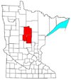
Crow Wing County is a county in the East Central part of the U.S. state of Minnesota. As of the 2020 census, the population was 66,123. Its county seat is Brainerd. The county was formed in 1857, and was organized in 1870.

<span class="mw-page-title-main">Boy River, Minnesota</span> City in Minnesota, United States

Boy River is a city in Cass County, Minnesota, United States. The population was 47 at the 2010 census. It is part of the Brainerd Micropolitan Statistical Area.

<span class="mw-page-title-main">East Gull Lake, Minnesota</span> City in Minnesota, United States

East Gull Lake is a city in Cass County, Minnesota, United States. The population was 986 at the 2020 census. The nearest semi-urban area is that of Brainerd and Baxter. It is part of the Brainerd Micropolitan Statistical Area. East Gull Lake is in Central Minnesota's Brainerd Lakes Area and takes its name from the largest lake within its borders, Gull Lake.

<span class="mw-page-title-main">Hackensack, Minnesota</span> City in Minnesota, United States

Hackensack is a city in Cass County, Minnesota, United States. The population was 313 at the 2010 census. It is part of the Brainerd Micropolitan Statistical Area.

<span class="mw-page-title-main">Longville, Minnesota</span> City in Minnesota, United States

Longvillepronunciation  is a city in Cass County, Minnesota, United States. The population was 156 at the 2010 census. The city was named after its founder, Jim Long. It is roughly four hours north of the Twin Cities. It is part of the Brainerd Micropolitan Statistical Area. Minnesota State Highway 84 serves as a main route in the community, and Minnesota State Highway 200 is nearby. Longville is home to Longville Municipal Airport.

<span class="mw-page-title-main">Pillager, Minnesota</span> City in Minnesota, United States

Pillager is a city in Cass County, Minnesota, United States. The population was 469 at the 2010 census. It is part of the Brainerd Micropolitan Statistical Area.

<span class="mw-page-title-main">Baxter, Minnesota</span> City in Minnesota, United States

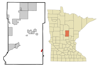
Baxter is a city in Crow Wing County, Minnesota, United States. The population was 7,610 at the 2010 census. It is part of the Brainerd Micropolitan Statistical Area.

<span class="mw-page-title-main">Brainerd, Minnesota</span> City in Minnesota, United States

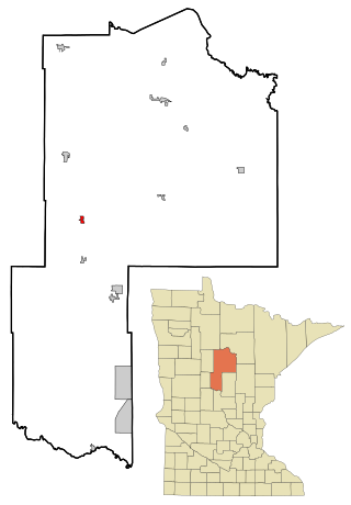
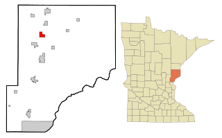
Brainerd is a city in Crow Wing County, Minnesota, United States. Its population was 14,395 at the 2020 census. It is the county seat of Crow Wing County. Brainerd straddles the Mississippi River several miles upstream from its confluence with the Crow Wing River, having been founded as a site for a railroad crossing above the confluence. Brainerd is the principal city of the Brainerd Micropolitan Area, a micropolitan area covering Cass and Crow Wing counties and with a combined population of 96,189 at the 2020 census. The city is well known for being the partial setting of the 1996 film Fargo.

<span class="mw-page-title-main">Crosby, Minnesota</span> City in Minnesota, United States

Crosby is a city in Crow Wing County, Minnesota, United States. The population was 2,386 at the 2010 census. It is part of the Brainerd Micropolitan Statistical Area. Crosby is adjacent to its twin city of Ironton, in the Cuyuna iron range.

<span class="mw-page-title-main">Crosslake, Minnesota</span> City in Minnesota, United States

Crosslake is a city in Crow Wing County, Minnesota, United States. The population was 2,141 at the 2010 census. It is part of the Brainerd Micropolitan Statistical Area.

<span class="mw-page-title-main">Fort Ripley, Minnesota</span> City in Minnesota, United States

Fort Ripley is a city in Crow Wing County, Minnesota, United States, near the confluence of the Mississippi and Nokasippi Rivers. The population was 69 at the 2010 census. It is part of the Brainerd Micropolitan Statistical Area.

<span class="mw-page-title-main">Garrison, Minnesota</span> City in Minnesota, United States

Garrison is a city in Crow Wing County, Minnesota, United States, along Mille Lacs Lake. The population was 210 at the 2010 census. It is part of the Brainerd Micropolitan Statistical Area. U.S. Highway 169 and Minnesota State Highway 18 are the main routes in the community.

<span class="mw-page-title-main">Jenkins, Minnesota</span> City in Minnesota, United States

Jenkins is a city in Crow Wing County, Minnesota, United States. The population was 430 at the 2010 census. It is part of the Brainerd Micropolitan Statistical Area.

<span class="mw-page-title-main">Riverton, Minnesota</span> City in Minnesota, United States

Riverton is a city in Crow Wing County, Minnesota, United States. The population was 117 at the 2010 census. It is part of the Brainerd Micropolitan Statistical Area.

<span class="mw-page-title-main">Henriette, Minnesota</span> City in Minnesota, United States

Henriette, is a city in Pine County, Minnesota, United States. The population was 71 at the 2010 census.

<span class="mw-page-title-main">Rutledge, Minnesota</span> City in Minnesota, United States

Rutledge is a city in Pine County, Minnesota, United States, at the confluence of the Kettle and Pine Rivers. The population was 229 at the 2010 census.

<span class="mw-page-title-main">Federal Dam, Minnesota</span> City in Minnesota, United States

Federal Dam is a city in Cass County, Minnesota, United States, near Leech Lake. The population was 110 at the 2010 census. It is part of the Brainerd Micropolitan Statistical Area.

<span class="mw-page-title-main">Fifty Lakes, Minnesota</span> City in Minnesota, United States

Fifty Lakes is a city in Crow Wing County, Minnesota, United States. The population was 387 at the 2010 census. It is part of the Brainerd Micropolitan Statistical Area.

<span class="mw-page-title-main">Motley, Minnesota</span> City in Minnesota, United States

Motley is a city in Cass and Morrison counties in the U.S. state of Minnesota. The population was 680 at the 2020 census. The main part of Motley is located within Morrison County; only a minor part of the city extends into Cass County

Grantsburg is a town in Burnett County in the U.S. state of Wisconsin. The population was 1,136 at the 2010 census. The village of Grantsburg is located within the town. The unincorporated communities of Branstad and Lind are located in the town.

References

  1. "Brainerd and Northern Minnesota--Minnesota and International Railway Depot". National Park Service. August 1, 2012.
  2. "Brainerd and Northern Minnesota--Minnesota and International Railway Depot". National Park Service. August 1, 2012.
  3. "2020 U.S. Gazetteer Files". United States Census Bureau. Retrieved July 24, 2022.
  4. 1 2 U.S. Geological Survey Geographic Names Information System: Pine River
  5. "2010 Census Redistricting Data (Public Law 94-171) Summary File". American FactFinder. U.S. Census Bureau, 2010 Census. Retrieved 23 April 2011.[ dead link ]
  6. Upham, Warren (2001). Minnesota Place Names: A Geographical Encyclopedia. Minnesota Historical Society Press. p. 96. ISBN   978-0-87351-396-8.
  7. "US Gazetteer files 2010". United States Census Bureau. Archived from the original on January 12, 2012. Retrieved 2012-11-13.
  8. United States Census Bureau. "Census of Population and Housing" . Retrieved July 14, 2014.
  9. "U.S. Census website". United States Census Bureau . Retrieved 2012-11-13.
  10. "Terry Baker". Pro Football Reference. Retrieved August 4, 2018.
46°43′05″N94°24′15″W / 46.71806°N 94.40417°W / 46.71806; -94.40417