Brainerd micropolitan area

Last updated
Brainerd Micropolitan Area
Brainerd, MN Micropolitan Statistical Area
NP Shops 5.jpg
Northern Pacific Railroad Shops Historic District
Brainerd micropolitan area
Interactive Map of Brainerd, MN μSA
Country Flag of United States.svg United States
State Flag of Minnesota.svg Minnesota
Largest city Brainerd
Time zone UTC−6 (CST)
  Summer (DST) UTC−5 (CDT)

The Brainerd Micropolitan Statistical Area, as defined by the United States Census Bureau, is an area consisting of Cass County and Crow Wing County in Northern Minnesota, anchored by the city of Brainerd. As of July 1, 2022 estimate placed the population at 99,222. [1]

Contents

Counties

Communities

Townships

Cass County

Crow Wing County

Demographics

Historical population
CensusPop.Note
1860 419
1870 58038.4%
1880 2,805383.6%
1890 10,099260.0%
1900 22,027118.1%
1910 28,48129.3%
1920 40,46342.1%
1930 41,2181.9%
1940 50,87223.4%
1950 50,343−1.0%
1960 48,854−3.0%
1970 52,1496.7%
1980 62,77220.4%
1990 66,0405.2%
2000 82,24924.5%
2010 91,06710.7%
2020 96,1895.6%
2022 (est.)99,222 [1] 3.2%
U.S. Decennial Census [2]
1790-1960 [3] 1900-1990 [4]
1990-2000 [5] 2010-2020

As of the census of 2000, there were 82,249 people, 33,143 households, and 22,908 families residing within the μSA. The racial makeup of the μSA was 93.97% White, 0.24% African American, 4.30% Native American, 0.28% Asian, 0.02% Pacific Islander, 0.18% from other races, and 1.01% from two or more races. Hispanic or Latino of any race were 0.73% of the population.

The median income for a household in the μSA was $35,961, and the median income for a family was $42,502. Males had a median income of $31,968 versus $22,064 for females. The per capita income for the μSA was $18,182.

See also

Related Research Articles

<span class="mw-page-title-main">Crow Wing County, Minnesota</span> County in Minnesota, United States

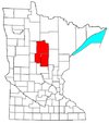
Crow Wing County is a county in the East Central part of the U.S. state of Minnesota. As of the 2020 census, the population was 66,123. Its county seat is Brainerd. The county was formed in 1857, and was organized in 1870.

<span class="mw-page-title-main">Cass County, Minnesota</span> County in Minnesota, United States

Cass County is a county in the central part of the U.S. state of Minnesota. As of the 2020 census, the population was 30,066. Its county seat is Walker. The county was formed in 1851, and was organized in 1897.

<span class="mw-page-title-main">Baxter, Minnesota</span> City in Minnesota, United States

Baxter is a city in Crow Wing County, Minnesota, United States. The population was 8,612 at the 2020 census. It is part of the Brainerd Micropolitan Statistical Area.

<span class="mw-page-title-main">Brainerd, Minnesota</span> City in Minnesota, United States

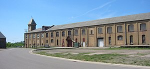
Brainerd is a city and the county seat of Crow Wing County, Minnesota, United States. Its population was 14,395 at the 2020 census. Brainerd straddles the Mississippi River several miles upstream from its confluence with the Crow Wing River, having been founded as a site for a railroad crossing above the confluence. Brainerd is the principal city of the Brainerd Micropolitan Area, a micropolitan area covering Cass and Crow Wing counties and with a combined population of 96,189 at the 2020 census. The city is well known for being the partial setting of the 1996 film Fargo.

<span class="mw-page-title-main">Crosslake, Minnesota</span> City in Minnesota, United States

Crosslake is a city in Crow Wing County, Minnesota, United States. The population was 2,141 at the 2010 census. It is part of the Brainerd Micropolitan Statistical Area.

<span class="mw-page-title-main">Jenkins, Minnesota</span> City in Minnesota, United States

Jenkins is a city in Crow Wing County, Minnesota, United States. The population was 430 at the 2010 census. It is part of the Brainerd Micropolitan Statistical Area.

<span class="mw-page-title-main">Motley, Minnesota</span> City in Minnesota, United States

Motley is a city in Morrison and Cass counties in the U.S. state of Minnesota. The population was 680 at the 2020 census. The main part of Motley is located within Morrison County; only a minor part of the city extends into Cass County.

<span class="mw-page-title-main">Clarksburg micropolitan area</span> Combined Statistical Area in West Virginia, United States

The Clarksburg Micropolitan Statistical Area, as defined by the United States Census Bureau, is an area consisting of four counties in North-Central West Virginia, anchored by the city of Clarksburg.

<span class="mw-page-title-main">Kearney Micropolitan Statistical Area</span> Micropolitan Statistical Area in Nebraska, United States

The Kearney Micropolitan Statistical Area, as defined by the United States Census Bureau, is an area consisting of two counties in Nebraska, anchored by the city of Kearney.

<span class="mw-page-title-main">Rockford metropolitan area, Illinois</span> Combined Statistical Area in Illinois, United States

The Rockford Metropolitan Statistical Area, as defined by the United States Census Bureau, is an area consisting of four counties in north-central Illinois, anchored by the city of Rockford. As of the 2010 census, the MSA had a population of 349,431. The Rockford MSA abuts the southern portions of the Janesville-Beloit MSA and the Chicago MSA. It forms the main part of the larger Rockford–Freeport–Rochelle Combined Statistical Area.

<span class="mw-page-title-main">Roanoke Rapids, North Carolina micropolitan area</span> Micropolitan Statistical Area in North Carolina, United States

The Roanoke Rapids, NC Micropolitan Statistical Area (μSA) as defined by the United States Census Bureau, is an area consisting of two counties in North Carolina, anchored by the city of Roanoke Rapids.

<span class="mw-page-title-main">Ardmore, Oklahoma micropolitan area</span> Micropolitan Statistical Area in Oklahoma, United States

The Ardmore Micropolitan Statistical Area, as defined by the United States Census Bureau, is an area consisting of one county in South Central Oklahoma, anchored by the city of Ardmore.

<span class="mw-page-title-main">Burlington, Iowa micropolitan area</span> Micropolitan Statistical Area in the United States

The Burlington, IA−IL Micropolitan Statistical Area, as defined by the United States Census Bureau, is an area consisting of two counties−one in southeast Iowa and the other in West Central Illinois, anchored by the city of Burlington, Iowa.

<span class="mw-page-title-main">Mount Vernon, Illinois, micropolitan area</span> Micropolitan Statistical Area in Illinois, United States

The Mount Vernon, IL Micropolitan Statistical Area, as defined by the United States Census Bureau, is an area consisting of one county in southern Illinois, anchored by the city of Mount Vernon.

<span class="mw-page-title-main">Jacksonville, Illinois, micropolitan area</span> Micropolitan Statistical Area in Illinois, United States

The Jacksonville, IL Micropolitan Statistical Area, as defined by the United States Census Bureau, is an area consisting of two counties in west central Illinois, anchored by the city of Jacksonville.

The Fort Madison–Keokuk, IA-IL-MO Micropolitan Statistical Area, as defined by the United States Census Bureau, locally known as the "Tri-State" area, was an area consisting of three counties – one in southeast Iowa, one in northeast Missouri, and one in west central Illinois, anchored by the cities of Fort Madison, Iowa and Keokuk, Iowa. As of the 2010 census, the μSA had a population of 62,105. An estimate by the Census Bureau, as of July 1, 2012, placed the population at 61,477, a decrease of 1.01%. When the 2023 definitions were released this area was dissolved with Lee County, Iowa being included as part of the Burlington–Fort Madison, IA–IL Combined Statistical Area.

<span class="mw-page-title-main">Safford, Arizona micropolitan area</span> US Census Bureau statistical area (μSA)

The Safford Micropolitan Statistical Area, as defined by the United States Census Bureau, is a micropolitan statistical area (μSA) consisting of one county in eastern Arizona, anchored by the city of Safford.

<span class="mw-page-title-main">Alexander City micropolitan area</span>

The Alexander City Micropolitan Statistical Area is a former micropolitan statistical area that consisted of two counties in Alabama, anchored by the city of Alexander City, as defined by the United States Census Bureau. As of the 2010 census, the μSA had a population of 53,155.

The Wahpeton Micropolitan Statistical Area, as defined by the United States Census Bureau, is an area consisting of two counties – one in southeast North Dakota and one in west central Minnesota, anchored by the city of Wahpeton, North Dakota. As of the 2010 census, the μSA had a population of 22,897.

<span class="mw-page-title-main">Dickinson, North Dakota micropolitan area</span> Area consisting of two counties in North Dakota

The Dickinson Micropolitan Statistical Area, as defined by the United States Census Bureau, is an area consisting of two counties in North Dakota, anchored by the city of Dickinson. As of the 2010 census, the μSA had a population of 24,982.

References

  1. 1 2 "Annual Estimates of the Resident Population for Counties: April 1, 2020 to July 1, 2022" . Retrieved April 14, 2023.
  2. "U.S. Decennial Census". United States Census Bureau. Retrieved October 6, 2014.
  3. "Historical Census Browser". University of Virginia Library. Retrieved October 6, 2014.
  4. "Population of Counties by Decennial Census: 1900 to 1990". United States Census Bureau. Retrieved October 6, 2014.
  5. "Census 2000 PHC-T-4. Ranking Tables for Counties: 1990 and 2000" (PDF). United States Census Bureau. Archived (PDF) from the original on March 27, 2010. Retrieved October 6, 2014.