Chickamaw Beach, Minnesota

Last updated

Chickamaw Beach
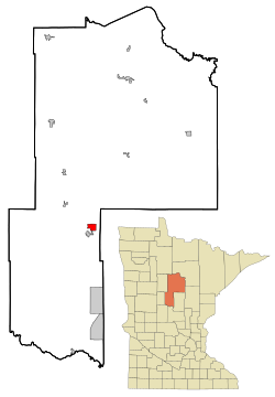
Cass County Minnesota Incorporated and Unincorporated areas Chickamaw Beach Highlighted.svg
Location of Chickamaw Beach
within Cass County, Minnesota
Coordinates: 46°44′33″N94°23′59″W / 46.74250°N 94.39972°W / 46.74250; -94.39972
Country United States
State Minnesota
County Cass
Area
[1]
  Total2.64 sq mi (6.85 km2)
  Land2.25 sq mi (5.84 km2)
  Water0.39 sq mi (1.01 km2)
Elevation
1,302 ft (397 m)
Population
 (2020)
  Total128
  Density56.81/sq mi (21.93/km2)
Time zone UTC-6 (Central (CST))
  Summer (DST) UTC-5 (CDT)
FIPS code 27-11296 [2]
GNIS feature ID0641152 [3]

Chickamaw Beach is a city in Cass County, Minnesota, United States. The population was 114 at the 2010 census. [4] It is part of the Brainerd Micropolitan Statistical Area.

Contents

History

Chickamaw Beach was incorporated in 1950. [5]

Geography

According to the United States Census Bureau, the city has a total area of 2.61 square miles (6.76 km2), of which, 2.22 square miles (5.75 km2) is land and 0.39 square miles (1.01 km2) is water. [6]

Minnesota State Highway 84 serves as a main route in the community. Minnesota State Highway 371 is nearby.

Demographics

Historical population
CensusPop.Note
1960 76
1970 8714.5%
1980 12442.5%
1990 1326.5%
2000 14812.1%
2010 114−23.0%
2020 12812.3%
U.S. Decennial Census [7]

2010 census

As of the census [8] of 2010, there were 114 people, 58 households, and 35 families living in the city. The population density was 51.4 inhabitants per square mile (19.8/km2). There were 111 housing units at an average density of 50.0 per square mile (19.3/km2). The racial makeup of the city was 100.0% White. Hispanic or Latino of any race were 1.8% of the population.

There were 58 households, of which 12.1% had children under the age of 18 living with them, 58.6% were married couples living together, 1.7% had a female householder with no husband present, and 39.7% were non-families. 27.6% of all households were made up of individuals, and 10.3% had someone living alone who was 65 years of age or older. The average household size was 1.97 and the average family size was 2.40.

The median age in the city was 57.5 years. 10.5% of residents were under the age of 18; 0.9% were between the ages of 18 and 24; 15.8% were from 25 to 44; 43.8% were from 45 to 64; and 28.9% were 65 years of age or older. The gender makeup of the city was 50.9% male and 49.1% female.

2000 census

As of the census [2] of 2000, there were 148 people, 63 households, and 45 families living in the city. The population density was 67.7 inhabitants per square mile (26.1/km2). There were 110 housing units at an average density of 50.3 per square mile (19.4/km2). The racial makeup of the city was 100.00% White.

There were 63 households, out of which 23.8% had children under the age of 18 living with them, 71.4% were married couples living together, 1.6% had a female householder with no husband present, and 27.0% were non-families. 22.2% of all households were made up of individuals, and 11.1% had someone living alone who was 65 years of age or older. The average household size was 2.35 and the average family size was 2.78.

In the city, the population was spread out, with 18.2% under the age of 18, 4.7% from 18 to 24, 14.2% from 25 to 44, 39.9% from 45 to 64, and 23.0% who were 65 years of age or older. The median age was 50 years. For every 100 females, there were 102.7 males. For every 100 females age 18 and over, there were 98.4 males.

The median income for a household in the city was $28,750, and the median income for a family was $43,750. Males had a median income of $27,250 versus $16,071 for females. The per capita income for the city was $20,223. There were 2.6% of families and 5.4% of the population living below the poverty line, including no under eighteens and 16.7% of those over 64.
Related Research Articles

<span class="mw-page-title-main">Benedict, Kansas</span> City in Wilson County, Kansas

Benedict is a city in Wilson County, Kansas, United States, along the Verdigris River. As of the 2020 census, the population of the city was 69.

<span class="mw-page-title-main">Funkley, Minnesota</span> City in Minnesota, United States

Funkley is a city in Beltrami County, Minnesota, United States. The population was 18 at the 2020 census, making the city the second-least populous incorporated place in Minnesota. It shared that distinction with Tenney until the latter dissolved in 2011.

<span class="mw-page-title-main">Kelliher, Minnesota</span> Town in Minnesota, United States

Kelliher is a city in Beltrami County, Minnesota, United States. The population was 258 at the 2020 census. Minnesota State Highway 72 is the primary route through Kelliher.

<span class="mw-page-title-main">Backus, Minnesota</span> City in Minnesota, United States

Backus is a city in Cass County, Minnesota, United States. The population was 250 at the 2010 census. It is part of the Brainerd Micropolitan Statistical Area.

Barclay Township is a township in Cass County, Minnesota, United States. As of the 2000 census, its population was 516. Barclay Township was named for an early settler.

<span class="mw-page-title-main">Lake Shore, Minnesota</span> City in Minnesota, United States

Lake Shore is a city in Cass County, Minnesota, United States. The population was 1,056 at the 2020 census. It is part of the Brainerd Micropolitan Statistical Area.

<span class="mw-page-title-main">Emily, Minnesota</span> City in Minnesota, United States

Emily is a city in Crow Wing County, Minnesota, United States. The population was 813 at the 2010 census. It is part of the Brainerd Micropolitan Statistical Area.

<span class="mw-page-title-main">Fort Ripley, Minnesota</span> City in Minnesota, United States

Fort Ripley is a city in Crow Wing County, Minnesota, United States, near the confluence of the Mississippi and Nokasippi Rivers. The population was 69 at the 2010 census. It is part of the Brainerd Micropolitan Statistical Area.

<span class="mw-page-title-main">Trommald, Minnesota</span> City in Minnesota, United States

Trommald is a city in Crow Wing County, Minnesota, United States. The population was 98 at the 2010 census. It is part of the Brainerd Micropolitan Statistical Area.

<span class="mw-page-title-main">Kenyon, Minnesota</span> City in Minnesota, United States

Kenyon is a city in southwestern Goodhue County, Minnesota, United States, located along the North Fork of the Zumbro River. It was founded in 1856 and named in honor of Kenyon College. It is known for the Boulevard of roses on main street, which is the namesake of the town festival "Rosefest" held every August. The population was 1,815 at the 2010 census.

<span class="mw-page-title-main">Coleraine, Minnesota</span> City in Minnesota, United States

Coleraine is a city in Itasca County, Minnesota, United States. The population was 1,970 at the 2010 census. The community was named after Thomas F. Cole, President of the Oliver Iron Mining Company.

<span class="mw-page-title-main">Plato, Minnesota</span> City in Minnesota, United States

Plato is a city in eastern McLeod County, Minnesota, United States. The population was 320 at the 2010 census.

<span class="mw-page-title-main">Buckman, Minnesota</span> City in Minnesota, United States

Buckman is a city in Morrison County, Minnesota, United States. The population was 307 at the 2020 Census.

<span class="mw-page-title-main">Harding, Minnesota</span> City in Minnesota, United States

Harding is a city in Morrison County, Minnesota, United States, along the Platte River. The population was 123 at the 2020 census.

<span class="mw-page-title-main">Bluffton, Minnesota</span> City in Minnesota, United States

Bluffton is a city in Otter Tail County, Minnesota, United States, along the Leaf River. The population was 210 at the 2020 census.

<span class="mw-page-title-main">Henriette, Minnesota</span> City in Minnesota, United States

Henriette, is a city in Pine County, Minnesota, United States. The population was 71 at the 2010 census.

<span class="mw-page-title-main">Maple Lake, Minnesota</span> City in Minnesota, United States

Maple Lake is a city in Wright County, Minnesota, United States. The population was 2,159 at the 2020 census. Minnesota State Highway 55 serves as a main route in the city.

<span class="mw-page-title-main">South Miami Heights, Florida</span> Census-designated place in Florida, United States

South Miami Heights is a census-designated place (CDP), originally known as Eureka, in Miami-Dade County, Florida. The population was 36,770 as of the 2020 census.

<span class="mw-page-title-main">Genola, Minnesota</span> City in Minnesota, United States

Genola is a city in Morrison County, Minnesota, United States. The population was 70 at the 2020 census.

<span class="mw-page-title-main">Fall River, Wisconsin</span> Village in Wisconsin, United States

Fall River is a village in Columbia County, Wisconsin, United States, along the North Fork of the Crawfish River. The population was 1,712 at the 2010 census. It is part of the Madison Metropolitan Statistical Area.

References

  1. "2020 U.S. Gazetteer Files". United States Census Bureau. Retrieved July 24, 2022.
  2. 1 2 "U.S. Census website". United States Census Bureau . Retrieved January 31, 2008.
  3. "US Board on Geographic Names". United States Geological Survey. October 25, 2007. Retrieved January 31, 2008.
  4. "2010 Census Redistricting Data (Public Law 94-171) Summary File". American FactFinder. U.S. Census Bureau, 2010 Census. Retrieved April 23, 2011.[ dead link ]
  5. Upham, Warren (2001). Minnesota Place Names: A Geographical Encyclopedia. Minnesota Historical Society Press. p. 93. ISBN   978-0-87351-396-8.
  6. "US Gazetteer files 2010". United States Census Bureau. Archived from the original on January 25, 2012. Retrieved November 13, 2012.
  7. "Census of Population and Housing". Census.gov. Retrieved June 4, 2015.
  8. "U.S. Census website". United States Census Bureau . Retrieved November 13, 2012.

46°44′37″N94°23′07″W / 46.74361°N 94.38528°W / 46.74361; -94.38528