Federal Dam | |
---|---|
Motto: The Best Little City By A Dam Site" | |
Coordinates: 47°14′40″N94°13′3″W / 47.24444°N 94.21750°W | |
Country | United States |
State | Minnesota |
County | Cass |
Area | |
• Total | 2.23 sq mi (5.77 km2) |
• Land | 2.21 sq mi (5.72 km2) |
• Water | 0.02 sq mi (0.05 km2) |
Elevation | 1,309 ft (399 m) |
Population (2020) | |
• Total | 123 |
• Density | 55.66/sq mi (21.49/km2) |
Time zone | UTC-6 (Central (CST)) |
• Summer (DST) | UTC-5 (CDT) |
ZIP code | 56641 |
Area code | 218 |
FIPS code | 27-20798 [2] |
GNIS feature ID | 0656214 [3] |
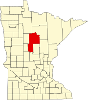
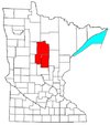
Federal Dam is a city in Cass County, Minnesota, United States, near Leech Lake. The population was 110 at the 2010 census. [4] It is part of the Brainerd Micropolitan Statistical Area.
A post office called Federal Dam was established in 1910. [5] The city took its name from a nearby dam constructed by the federal government of the United States. [6]
According to the United States Census Bureau, the city has a total area of 2.27 square miles (5.88 km2), of which 2.25 square miles (5.83 km2) is land and 0.02 square miles (0.05 km2) is water. [7] County Road 8 serves as a main route in the community. County Roads 4 and 63 are both nearby. The Leech Lake River flows nearby.
Historical population | |||
---|---|---|---|
Census | Pop. | %± | |
1920 | 332 | — | |
1930 | 278 | −16.3% | |
1940 | 269 | −3.2% | |
1950 | 225 | −16.4% | |
1960 | 185 | −17.8% | |
1970 | 147 | −20.5% | |
1980 | 192 | 30.6% | |
1990 | 118 | −38.5% | |
2000 | 101 | −14.4% | |
2010 | 110 | 8.9% | |
2020 | 123 | 11.8% | |
U.S. Decennial Census [8] |
As of the census [9] of 2010, there were 110 people, 49 households, and 26 families living in the city. The population density was 48.9 inhabitants per square mile (18.9/km2). There were 137 housing units at an average density of 60.9 per square mile (23.5/km2). The racial makeup of the city was 56.4% White, 23.6% Native American, and 20.0% from two or more races.
There were 49 households, of which 28.6% had children under the age of 18 living with them, 36.7% were married couples living together, 6.1% had a female householder with no husband present, 10.2% had a male householder with no wife present, and 46.9% were non-families. 32.7% of all households were made up of individuals, and 12.3% had someone living alone who was 65 years of age or older. The average household size was 2.24 and the average family size was 2.92.
The median age in the city was 48 years. 23.6% of residents were under the age of 18; 8.2% were between the ages of 18 and 24; 13.6% were from 25 to 44; 38.2% were from 45 to 64; and 16.4% were 65 years of age or older. The gender makeup of the city was 50.0% male and 50.0% female.
As of the census [2] of 2000, there were 101 people, 43 households, and 23 families living in the city. The population density was 53.3 inhabitants per square mile (20.6/km2). There were 81 housing units at an average density of 42.7 per square mile (16.5/km2). The racial makeup of the city was 71.29% White, 18.81% Native American, 0.99% Asian, and 8.91% from two or more races.
There were 43 households, out of which 23.3% had children under the age of 18 living with them, 39.5% were married couples living together, 11.6% had a female householder with no husband present, and 44.2% were non-families. 41.9% of all households were made up of individuals, and 14.0% had someone living alone who was 65 years of age or older. The average household size was 2.35 and the average family size was 3.29.
In the city, the population was spread out, with 35.6% under the age of 18, 5.0% from 18 to 24, 18.8% from 25 to 44, 20.8% from 45 to 64, and 19.8% who were 65 years of age or older. The median age was 40 years. For every 100 females, there were 98.0 males. For every 100 females age 18 and over, there were 97.0 males.
The median income for a household in the city was $22,917, and the median income for a family was $27,188. Males had a median income of $11,250 versus $21,250 for females. The per capita income for the city was $12,414. There were 18.5% of families and 28.0% of the population living below the poverty line, including 45.7% of under eighteens and 17.2% of those over 64.
Jewett is a village in Cumberland County, Illinois, United States. The population was 223 at the 2010 census. It is part of the Charleston–Mattoon Micropolitan Statistical Area.
Oakwood Hills is a village in McHenry County, Illinois, United States. Oakwood Hills was founded in 1959. The population was 2,083 at the 2010 census. As of 2018, the population dropped to 2,041.
Plymouth is a city in Cerro Gordo County, Iowa, United States, along the Shell Rock River. The population was 375 at the time of the 2020 census. It is part of the Mason City Micropolitan Statistical Area.
DelhiDEL-hy is a city in Delaware County, Iowa, United States. The population was 420 at the time of the 2020 census.
Fort Polk South is a census-designated place (CDP) in Vernon Parish, Louisiana, United States. The population was 11,000 at the 2000 census.
Charlotte is a town in Washington County, Maine, United States. The town was named for the wife of legislator William Vance. The population was 337 at the 2020 census.
Delhi is a city in Redwood County, Minnesota, United States. The population was 70 at the 2010 census.
Winton is a city in Saint Louis County, Minnesota, United States. The population was 172 at the 2010 census. The city is home to a small hydroelectric dam on the edge of Garden Lake, one of 11 stations owned by Minnesota Power.
Zumbro Falls is a city along the Zumbro River in Wabasha County, Minnesota, United States. The population was 207 at the 2010 census. U.S. Highway 63 and Minnesota 60 intersect in Zumbro Falls.
Preston is a village in Hickory County, Missouri, United States. The population was 157 at the 2020 census.
Virginia is a village in Gage County, Nebraska, United States. The population was 60 at the 2010 census.
Ostrander is a village in Delaware County, Ohio, United States. The population was 643 at the 2010 census.
Point Blank is a city in San Jacinto County, Texas, United States. The population was 643 at the 2020 census.
Noonday is a city in Smith County, Texas, United States. The population was 612 at the 2020 census. It is part of the Tyler, Texas Metropolitan Statistical Area.
Tselakai Dezza is a census-designated place (CDP) in San Juan County, Utah, United States. The population was 103 at the 2000 census.
Grand Coulee is a city in Grant County, Washington, United States. The population was 972 at the 2020 census.
MacArthur is a census-designated place (CDP) in Raleigh County, West Virginia, United States. Originally, it was named Hollywood and renamed MacArthur after General of the Army Douglas MacArthur in 1942. The population was 1,500 at the 2010 census.
Coulee Dam is a town in Douglas, Grant, and Okanogan counties in the State of Washington. The Douglas County portion of Coulee Dam is part of the Wenatchee–East Wenatchee Metropolitan Statistical Area. The population was 1,211 as of the 2020 census.
Beaver Dam is a town in Dodge County, Wisconsin, United States. The population was 3,440 at the 2000 census. The City of Beaver Dam is located within the town. The unincorporated communities of Beaver Edge, Leipsig and Sunset Beach are also located in the town. The ghost town of Clason Prairie was also located in the town.
Howland Center is an unincorporated community and census-designated place in south-central Trumbull County, Ohio, United States. The population was 6,351 at the 2020 census. A suburb consisting of unincorporated urban portions of Howland Township, it is part of the Youngstown–Warren metropolitan area.