Otter Tail County is a county in the U.S. state of Minnesota. As of the 2020 census, its population was 60,081. Its county seat is Fergus Falls. Otter Tail County comprises the Fergus Falls micropolitan statistical area. With 1,048 lakes in its borders, Otter Tail County has more lakes than any other county in the United States.

Hubbard County is a county in the northwestern part of the U.S. state of Minnesota. As of the 2020 census, the population was 21,344. Its county seat is Park Rapids.

Crow Wing County is a county in the East Central part of the U.S. state of Minnesota. As of the 2020 census, the population was 66,123. Its county seat is Brainerd. The county was formed in 1857, and was organized in 1870.

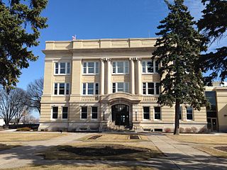
Cass County is a county in the central part of the U.S. state of Minnesota. As of the 2020 census, the population was 30,066. Its county seat is Walker. The county was formed in 1851, and was organized in 1897.

Beltrami County is a county in the northern part of the U.S. state of Minnesota. As of the 2020 census, the population was 46,228. Its county seat is Bemidji. The county's name comes from Italian adventurer Giacomo Beltrami from Bergamo, who explored the area in 1825. The county was created in 1866 and organized in 1896.

Bemidji is a city and the county seat of Beltrami County, in northern Minnesota, United States. The population was 14,574 at the 2020 census. According to 2022 census estimates, the city is estimated to have a population of 15,946, making it the largest commercial center between Grand Forks, North Dakota and Duluth.

Cass Lake is a city in Cass County, Minnesota, United States, located within the boundaries of the Leech Lake Indian Reservation. It is surrounded by Pike Bay Township. Cass Lake had a population of 675 in the 2020 census. It is notable as the headquarters location of Minnesota Chippewa Tribe and Leech Lake Band of Ojibwe, as well as the Chippewa National Forest.
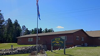
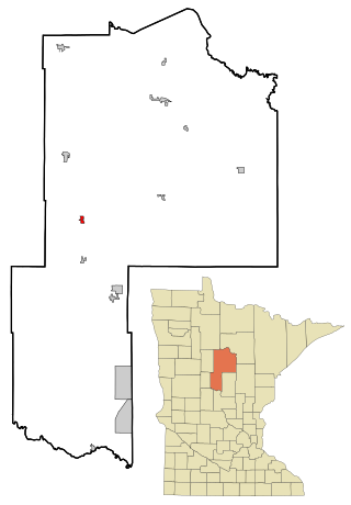
Crooked Lake Township is a township in Cass County, Minnesota, United States. The population was 498 as of the 2000 census. It is named after Roosevelt Lake, formerly known as Crooked Lake, a large lake located in this township. Crooked Lake is a translation from the Ojibwe Wewaagigamaag-zaaga'igan.
Hackensack is a city in Cass County, Minnesota, United States. The population was 313 at the 2010 census. It is part of the Brainerd Micropolitan Statistical Area.

Pipestone is a city and the county seat of Pipestone County, Minnesota. The population was 4,215 at the 2020 census. The city is also the site of the Pipestone National Monument.

Aurora is a city in Saint Louis County, Minnesota, United States. The population was 1,678 at the 2020 census.

The Leech Lake Reservation is an Indian reservation located in the north-central Minnesota counties of Cass, Itasca, Beltrami, and Hubbard. The reservation forms the land base for the federally recognized Leech Lake Band of Ojibwe, one of six bands comprising the Minnesota Chippewa Tribe, organized in 1934. The Leech Lake Reservation has the second highest population of any reservation in Minnesota with White Earth Nation being the largest Minnesota Ojibwe tribe, Leech Lake Nation has a resident population of 11,388 indicated by the 2020 census.
Pontoria is an unincorporated community in Ponto Lake Township, Cass County, Minnesota, United States, near Backus.
Whipholt is an unincorporated community and census-designated place (CDP) in Pine Lake Township, Cass County, Minnesota, United States, along Leech Lake. Its population was 99 as of the 2010 census. The community is located along State Highway 200 near Pine Lake Road. Whipholt is 13 miles east of Walker.
Oshawa is an unincorporated community in Cass County, Minnesota, United States, near Backus. The community is located near the junction of Cass County Road 41 and State Highway 87. Oshawa is located within Bull Moose Township and Deerfield Township. The Badoura State Forest and the Foot Hills State Forest are both nearby.
Wilkinson is an unincorporated community in Wilkinson Township, Cass County, Minnesota, United States, near Cass Lake and Walker. It is located along State Highway 371 near 122nd Street NW.
Sylvan is an unincorporated community in Sylvan Township, Cass County, Minnesota, United States. It is located between Pillager and Baxter along State Highway 210, near 24th Avenue SW.
Raboin is an unincorporated community in Wilkinson Township, Cass County, Minnesota, United States, near Cass Lake and Walker. It is located along State Highway 371 near 134th Street NW.
Mae is an unincorporated community in Beulah Township, Cass County, Minnesota, United States, near Outing and Emily. It is located along Cass County Road 58, near Morrison Lake Road NE.
Leech Lake is an unincorporated community in Leech Lake Township, Cass County, Minnesota, United States. It is along State Highway 371 near 100th Street NW, Cass County Road 62. Nearby places include Walker, Laporte, and Steamboat Bay of Leech Lake.


