
The River Ouse is a river in North Yorkshire, England. Hydrologically, the river is a continuation of the River Ure, and the combined length of the River Ure and River Ouse makes it, at 129 miles (208 km), the sixth-longest river of the United Kingdom and the longest to flow entirely in one county. The length of the Ouse alone is about 52 miles (84 km) but the total length of the river is disputed.
Fulford is a historic village and civil parish on the outskirts of York, in the York district, in the ceremonial county of North Yorkshire, England. Fulford is located 2 miles (3 km) to the south of the city, on the east bank of the River Ouse.

There are nine bridges across the River Ouse and eighteen smaller bridges and passages across the narrower River Foss within the city of York, England.
Wressle is a village and civil parish in the East Riding of Yorkshire, England, lying on the eastern bank of the River Derwent approximately 3 miles (5 km) north-west of Howden.

Selby railway station is a Grade II listed station which serves the market town of Selby in North Yorkshire, England. The original terminus station was opened in 1834 for the Leeds and Selby Railway. The Hull and Selby Railway extended the line in 1840 and a new station was built, with the old station becoming a goods shed. The station was rebuilt in 1873 and 1891; the 1891 rebuilding was required due to the replacement of the swing bridge over the River Ouse at the same time.

Naburn is a small village and civil parish in the unitary authority of the City of York in the ceremonial county of North Yorkshire, England. It lies on the eastern side of the River Ouse about 4 miles (6.4 km) south of York. According to the 2001 census the parish had a population of 470, increasing to 516 at the 2011 census.

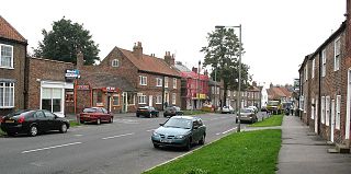
Cawood is a village and civil parish in North Yorkshire, England that is notable as the location of the Cawood sword. It was historically part of the West Riding of Yorkshire until 1974.

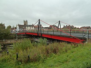
Cawood Bridge is a swing bridge which spans the Yorkshire River Ouse in North Yorkshire, England. Construction was authorised in 1870, with the formation of the Cawood Bridge bridge company. It was opened on 31 July 1872 to replace the ferry, and is located about halfway between Naburn and Selby. It is the only bridge from the village of Cawood that crosses the river. It is Grade II listed.

Whitgift is a small linear village and former civil parish, now in the parish of Twin Rivers, in the East Riding of Yorkshire, England approximately 4 miles (6.4 km) east of Goole. It is located alongside the River Ouse and north of the A161 road between Goole and Scunthorpe. Ousefleet and Reedness are to the east and west respectively. Historically Whitgift was part of the West Riding of Yorkshire. In 1961 the parish had a population of 191.

Little Ouseburn is a small village and civil parish in the Harrogate district of North Yorkshire, England. It is situated near the A1(M) motorway and 6 miles (9.7 km) south-east of Boroughbridge. It consists of two roads, Main Street which is the residential area, and Church Lane which contains a Holy Trinity Church that is a grade I listed building. It also has a small brick bridge over a stream which leads to Great Ouseburn. According to the 2011 census data the total population of Little Ouseburn is 264.

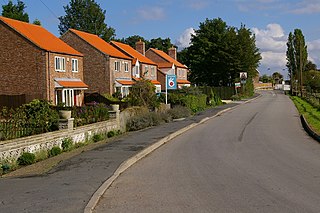
Stillingfleet is a village and civil parish in North Yorkshire, England. It was in the historic East Riding of Yorkshire, but since 1974 has come under North Yorkshire. It is about 6 miles (10 km) south of York and nearby settlements include Acaster Selby, Naburn and Appleton Roebuck.

The Selby Canal is a 6-mile (9.7 km) canal with 2 locks which bypasses the lower reaches of the River Aire in Yorkshire, England, from the village of West Haddlesey to the town of Selby where it joins the River Ouse. It opened in 1778, and provided the main outlet for the Aire and Calder Navigation until 1826, when it was bypassed by a new cut from Ferrybridge to Goole. Selby steadily declined after that, although traffic to York still used the canal.

The Skelton Viaduct, also known as the Hook bridge or Goole railway swing bridge, is a large viaducted hogback plate girder bridge with swing span over the River Ouse, Yorkshire near Goole, East Riding of Yorkshire, England. The bridge was designed by Thomas Elliot Harrison for the Hull and Doncaster Branch of the North Eastern Railway and opened in 1869.

The York and Doncaster branch was a railway line that opened in 1871 connecting Doncaster with York via Selby in Yorkshire, England. This line later became part of the East Coast Main Line (ECML) and was the route that express trains took between London King's Cross, the north of England and Scotland. It was opened by the North Eastern Railway (NER) between York and Shaftholme Junction, some 4.5 miles (7.2 km) north of Doncaster railway station. Between its opening in 1871 and the grouping in 1923, the line was used by both the NER, and the Great Northern Railway (GNR). All of the intermediate local stations that had opened with the line in 1871 closed down in the 1950s and 1960s leaving just Selby open between the town of Doncaster and the city of York.

Skeldergate is a street in the city centre of York, in England. The street is now primarily residential, with many of its warehouse buildings having been converted into apartments.

The River Ouse swing bridge is a road bridge over the River Ouse in North Yorkshire, England. It was opened in 2004 when the A63 road bypassed the town of Selby, which traffic previously had to go through to cross the river. It is one of several bridges over the River Ouse between York and the mouth of the Ouse, where it joins the River Trent.

Boothferry Bridge is a crossing over the River Ouse, between the East Riding and West Yorkshire, England, some 2 miles (3.2 km) north-west of Goole. The bridge was opened in 1929, replacing a ferry crossing immediately west of the bridge's location. The Act of Parliament for the building of the bridge in 1925, gave priority to river traffic. This situation still exists, though there have been some attempts to change priorities. On opening, it was the furthest crossing downstream of the river, cutting 25 miles (40 km) off the journey south to London from Kingston upon Hull. The M62 Ouse Bridge opened up to the east of Boothferry Bridge in 1976.
Selby Toll Bridge is one of three swing bridges in the town of Selby, North Yorkshire, England. A timber bridge over the River Ouse in the town was opened in c. 1793 to replace a ferry crossing that had existed since Medieval times. The bridge provided a connection between the West and East Ridings of Yorkshire across the River Ouse, and became the furthest downstream public bridge crossing over the river until 1929, when the Boothferry Bridge was built. The moving section of the original bridge used ball-bearings and cog wheels; the bridge is believed to be the first in the world to use ball-bearings. The replacement 1970s bridge, now only carries the A19 road as the A63 bypass was opened in 2004.
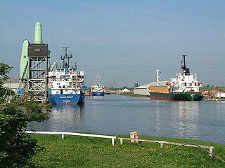
The Port of Goole, is a maritime port at the mouth of the Aire and Calder Navigation where it feeds into the River Ouse, in the East Riding of Yorkshire, England. The port opened in 1826, when the Aire and Calder Navigation was completed, connecting to the River Ouse at what is now the town of Goole. The port is one of the Humber Ports, associated with the waterway of the Humber Estuary and its tributaries, and is known to be Britain's largest inland port, being some 50 miles (80 km) from the open sea. It has good road and rail transport links, and deals with about £800 million worth of trade each year.
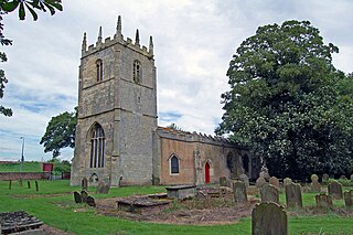
The Church of St Mary Magdalene is an Anglican church in the hamlet of Whitgift, East Riding of Yorkshire, England. The church is noted for its clock which displays the number 13 in Roman numerals in what should be the 12 o'clock position – the only one in Britain to do so. The church itself is a grade I listed building, and the churchyard contains two grade II listed structures.
