Bridges of York

Last updated

York bridges map.svg

There are nine bridges across the River Ouse and eighteen smaller bridges and passages across the narrower River Foss within the city of York, England.

Contents

Bridges over the Ouse

An engraving of the fourth Ouse Bridge (1565-1810) Engraving of Old Ouse Bridge.jpeg
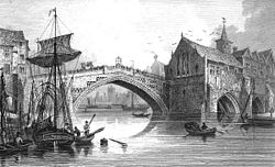
An engraving of the fourth Ouse Bridge (1565–1810)

The earliest bridge, built by the Romans, linked Stonegate (the via praetoria of the Roman fortress) and Micklegate, and crossed the river approximately where the Guildhall now is. Its replacement, Ouse Bridge, was a wooden bridge built about 380 yards (350 m) downstream by the Vikings. It has been rebuilt three times, most recently between 1810 and 1820. The Scarborough Railway Bridge of 1845 was the second bridge to be built, and it was followed by two more road bridges, Lendal Bridge in 1863 and Skeldergate Bridge in 1882. The Millennium Bridge, a footbridge, was added in 2001. There are also Clifton Bridge in the northern suburbs of the city, two modern fly-overs carrying the outer ring road, and the former railway bridge at Naburn, which is now part of the York-Selby cycle path.

North to south, the bridges are:

BridgeBuiltType
A1237Outer Ring Road, Western and Northern1987Road
Clifton Bridge1963Road
Scarborough Railway Bridge1844Rail and pedestrian
Lendal Bridge1863Road
Ouse Bridge1821Road
Skeldergate Bridge1881Road
Millennium Bridge2001Pedestrian
A64 — Outer Ring Road, Southern and Eastern1976Road
Naburn railway bridge1871Pedestrian

Clifton Bridge (1963)

Clifton bridge Clifton-bridge.jpg
Clifton bridge

A temporary bridge over the River Ouse at Clifton was built by the British Army in 1961 on the site of an old ferry crossing to handle additional vehicle traffic caused by the wedding of the Duke and Duchess of Kent at York Minster. A permanent bridge was opened officially on 28 October 1963. The bridge is built from 4,000 tons of concrete and 50 tons of reinforced steel. [1] [2]

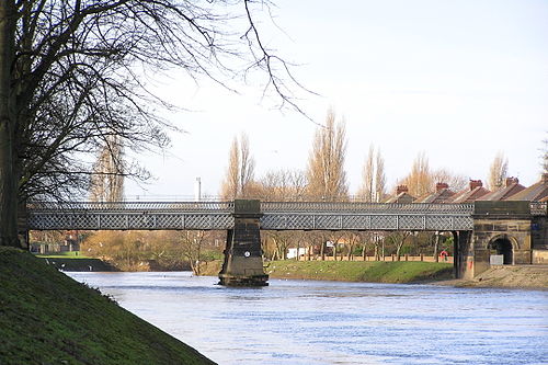
Scarborough Railway Bridge (1845)

Scarborough Railway Bridge from the South Bank, looking upstream Scarborough Railway Bridge York 2.jpg
Scarborough Railway Bridge from the South Bank, looking upstream

The second bridge across the Ouse was the Scarborough Railway Bridge, built in 1845 to carry the railway line between York and Scarborough (now the Scarborough branch of the North TransPennine route). Originally it had two tracks with a pedestrian path in between them. In 1875, the track was raised 4 feet (1.2 m) and the footpath moved to the south side. This bridge had a £6 million renovation in 2015 with the main decks being completely replaced. [3] The narrow footpath, with steps on either side was removed in 2019 and replaced with a much wider bridge suitable for pedestrians and cyclists. [4] It has created a car-free route between the railway station and the city centre and users of National Cycle Network route 65 no longer have to carry their bikes across the bridge. [5] The bridge reopened to the public on 18 April 2019 with work continuing on steps and sections of ramps. [6]

Lendal Bridge (1863)

Lendal Bridge from the South Bank, looking downstream Lendal Bridge York.jpg
Lendal Bridge from the South Bank, looking downstream

Lendal Bridge stands on the site of a former rope-ferry where the city walls break for the River Ouse. This was the ferry used by Florence Nightingale when she visited York en route to Castle Howard in 1852[ citation needed ].

The bridge connects two medieval towers: Lendal Tower on the east bank and Barker Tower on the west bank. It was designed by civil engineer Thomas Page, who also designed London's Westminster Bridge. It is made of cast iron, and has a single span of 175 feet (53 m). [7]

View of the ruins of the bridge taken immediately after its fall View of the Ruins of Lendal Bridge, York, taken immediately after its Fall. - ILN 1861 (14757687606) (cropped).jpg
View of the ruins of the bridge taken immediately after its fall

Page's bridge was the second attempt to build a bridge on the site. The first, begun in 1860 by William Dredge, collapsed during construction, and five workmen were killed. Parts of the structure were later taken to Scarborough and used in the Valley Bridge there. [8]

In 1861, permission was obtained from Parliament for a new bridge to be built, and the Corporation of York requested Thomas Page to design a replacement. His Gothic Revival bridge opened in 1863. [9] Together with the attached tollhouses it is a Grade II listed building. [10] In August 1892, champion diver Tommy Burns dived off the bridge, watched by several hundred spectators and afterwards "gave an exhibition of ornamental swimming". [11]

Lendal Bridge links Station Road with Museum Street and thus York railway station with York Minster, and is part of York's Inner Ring Road. The Maltings pub, near the south end of the bridge, was formerly named the "Lendal Bridge Hotel". [12]

Lendal Bridge was used in Damon and Debbie , a 1987 spin-off of soap Brookside for the scenes where long-running character Damon Grant was murdered. The BBC Television series 'Gunpowder' (2017) used Lendal Bridge as a location. [13]

Motor traffic (except for buses) was restricted daily from 10.30 a.m. to 5.00 p.m. on Lendal Bridge during a six-month trial period from August 2013 to February 2014. The trial objectives were to establish whether a permanent restriction would reduce congestion in York city centre, improve the environment and improve the reliability of certain bus routes. The traffic ban was enforced with ANPR cameras. Air quality and bus route reliability increased during the trial but the public and business opinions on the trial were mixed and enforcement ruled invalid on a signage technicality so the bridge was re-opened to motor traffic after the trial. [14]

Ouse Bridge (1821)

Ouse Bridge from King's Staith, looking upstream York Ouse Bridge.jpg
Ouse Bridge from King's Staith, looking upstream

The original Roman bridge over the Ouse was eventually replaced by a wooden bridge built further downstream by the Vikings. In 1154, it collapsed under the weight of a crowd which had gathered to greet St William of York on his return from exile. It was replaced by a stone bridge. In 1367 the first public toilets in Yorkshire, and likely England, were opened on the bridge. [15] Part of the bridge was swept away by floods in the winter of 1564–5. The repaired bridge of 1565 had a new central arch spanning 81 ft, and was described by Defoe as "...near 70 foot [21 m] in diameter; it is, without exception, the greatest in England, some say it's as large as the Rialto at Venice, though I think not." This bridge was dismantled between 1810 and 1818 to make way for the New Ouse Bridge, designed by Peter Atkinson the younger, completed in 1821. [16] [17]

It is a Grade II listed building. [18]

Skeldergate Bridge (1881)

Skeldergate Bridge from the South Bank, looking upstream Skeldergate Bridge (geograph 7403256).jpg
Skeldergate Bridge from the South Bank, looking upstream

Skeldergate Bridge links the York Castle area to Bishophill. In 1875 Parliament passed the York (Skeldergate Bridge) Improvement Act, [19] after the city had determined that over 800 people were using the Skeldergate ferry crossing daily. It was designed in a Gothic Revival style by civil engineer George Gordon Page, and built between 1878 and 1881. The small arch at the east end had an opening portion, powered by machinery in the Motor House, which also served as a toll house and accommodation for the toll keeper and his family. [20] The bridge opened to admit tall masted ships to the quays on either side of the river between Skeldergate and Ouse Bridges. [21] The bridge was last opened in 1975, and the machinery has since been removed. Skeldergate Bridge was formally declared free of tolls on 1 April 1914. [22] Together with the attached tollhouse, now a cafe, it is a Grade II listed building. [23]

Millennium Bridge (2001)

53°56′41.33″N1°4′55.42″W / 53.9448139°N 1.0820611°W / 53.9448139; -1.0820611

York Millennium Bridge from the South Bank, looking downstream York millennium bridge.jpg
York Millennium Bridge from the South Bank, looking downstream

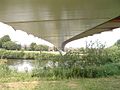
The Millennium Bridge, built to a competition-winning design by Whitby Bird and Partners, [24] was opened on 10 April 2001, having cost £4.2 million to build. It spans the River Ouse to the south of York, linking Hospital Fields Road and Maple Grove in Fulford with Butcher Terrace on the South Bank. The bridge carries a cycle path and a footpath, and is not open to vehicular traffic. It is a key link in the Sustrans National Cycle Routes 65/66 and is part of the orbital route for York completed in 2011. The bridge shortened the walk or cycle for students from houses in the South Bank to the University of York (they previously had to travel via Skeldergate Bridge).

The bridge also acts a meeting place for local people, as it has a waist height shelf spanning the whole structure which facilitates sitting and admiring the view. Increasingly it is used as a circular walk from the city centre taking in the New Walk on the east bank and Terry Avenue and Rowntree Park on the west bank. While riverside paths regularly flood several times a year the bridge is higher and rarely cut off by floodwaters. Signs on approaches from Fulford Road /Hospital Fields Road junction and Butcher Terrace/Bishopthorpe Road warn when it may be impassable without wellies.

At night the bridge is illuminated by banks of lights in different colours, so that the colour of illumination changes every few seconds.

Supplies for Fulford Barracks were brought in by river near this location, and the remains of a narrow gauge railway may be seen on the eastern bank of the river a few yards toward the city. There used to be a rope ferry at this location as well. There may have been a rope ferry at one time, but in the 20th century it was a sculled ferry (rowed by a single oar at the stern) right into the 1950s when the ferry boat became motorised. It was particularly used by the Terry's workers (with their bikes), who lived on the Fulford side of the Ouse.

Naburn Railway Bridge (1871)

Naburn bridge and sculpture from west bank Naburn railway bridge near York.jpg
Naburn bridge and sculpture from west bank

Outside the outer ring-road, the Naburn swing bridge, built in 1871, used to carry the York-Selby railway until it was diverted in 1983. The bridge now constitutes part of the York & Selby cycle path, connecting the Trans Pennine trail to York. [25] It is also known as the "Fisherman Bridge" due to a large metal sculpture of a fisherman with bike and dog, sitting on top which was added in 2000 as part of the York Council "Creative Communities 2000" scheme. [26]

Bridges over the Foss

Foss Bridge from the north, looking downstream York, Foss Bridge.jpg
Foss Bridge from the north, looking downstream

From north to south, to the confluence with the Ouse, these are:

BridgeBuiltType
A1237Outer Ring Road, Western and Northern1987Road
Church Lane Bridgec.1850 [27] Road
Station Avenue Bridgec.1890 [28] Pedestrian
Link Road Bridgec.1850 [29] Road
Yearsley Grove pedestrian bridgec.1890 [30] Pedestrian
Huntington Road Bridgec.1850 [31] Road
Fossway Bridgec.1940 [32] Road
Foss Islands Branch Line bridgec.1880Pedestrian
Monk Bridge (A1036)1794 [33] Road
Foss Bank Bridge (A1036)1998Road
Layerthorpe Bridge (A1036)1997 [34] Road
Defra pedestrian bridge1931Pedestrian
Hungate Bridge2011 [35] Pedestrian
Rowntree Wharf pedestrian bridgec.1990Pedestrian
Foss Bridge1812Road
Piccadilly Bridge1914Road
Castle Mills Bridge (A1036)1956 [36] Road
Blue Bridge1930 [37] Pedestrian

Many of these are small pedestrian crossings or unobtrusive modern bridges carrying main roads. The following are more notable:

Monk Bridge (1794)

Monk Bridge is a single-arched ashlar bridge with a span of approximately 20 feet (6 m). It carries traffic between central York and Heworth and was built in 1794 to designs by Peter Atkinson the elder. In 1924–6, the bridge was widened and the upper part rebuilt. [17]

Pedestrian bridge from Foss Island Road to Defra site (1931)

Defra pedestrian bridge from the west, looking downstream York- Locked pedestrian bridge.jpg
Defra pedestrian bridge from the west, looking downstream

This cast-iron pedestrian bridge from Foss Islands Road to what is now the Defra site at Peasholme Green was constructed in 1931 by the Monk Bridge Construction Company to improve communications between York's power station and its cooling tower, both now demolished. [38] It is locked and not in use.

Hungate Bridge (2011)

Hungate Bridge Pont Hungate York 1.jpg
Hungate Bridge

Opened in September 2011, [35] Hungate bridge is a cable-stayed cycle and foot bridge that links Navigation Road and Palmer Street. It has an 85 feet (26 m) [39] span with a single supporting mast on the north bank. [40]

National Cycle Network Route 658 uses the bridge. [41] It is also on the route of the Way of the Roses coast to coast route and is part of York's network of traffic-free cycleways. [35]

Foss Bridge (1812)

The Foss Bridge, a single Georgian gritstone arch with balusters, links the streets Fossgate and Walmgate. It is believed that the earliest bridge on this site was constructed during the Viking period. The present bridge, designed by Peter Atkinson the younger and erected in 1811–12, replaced a wooden bridge. The bridge was once the site of a fish market. [17] [42] It is a Grade II* listed building. [43]

Blue Bridge (1930)

Blue Bridge, where the Ouse meets the Foss. Blue Bridge (3352243100).jpg
Blue Bridge, where the Ouse meets the Foss.

The Blue Bridge crosses the River Foss just above its confluence with the River Ouse. The original bridge on the site was built in 1738, the current one being constructed in 192930.

In the early 1730s a section of the eastern river bank of the Ouse was improved, at the expense of the city, to create an area lined with trees along which the citizens could promenade. It proved so popular that within a few years this New Walk was extended further south past the junction with the Foss by way of a wooden drawbridge. [44] [45] This new bridge was painted blue and the colour and name have endured though the bridge itself has been replaced several times, [46] the first of these being in 1768 when a single-arch stone bridge was constructed. [47] In 1792 the Foss Navigation Company built a wooden swing-bridge to enable boats to access the Foss and this type of bridge was used again when the bridge was rebuilt in 1834. [46] In 185758 an iron opening-bridge was built along with two stone plinths upon which stood two Russian cannons. These had been captured at the Battle of Sebastopol in 1855 and became the Crimean War Memorial in York and as such were retained when the current bridge was built in 192930 only to be removed in 1941 when they were scrapped and reused for the war effort. [37] In 2020, the bridge was to be temporarily removed for refurbishments, with a scaffold bridge taking its place. [48]

Related Research Articles

<span class="mw-page-title-main">North Yorkshire</span> County of England

North Yorkshire is a ceremonial county in the Yorkshire and the Humber and North East regions of England. It borders County Durham to the north, the North Sea to the east, the East Riding of Yorkshire to the south-east, South Yorkshire to the south, West Yorkshire to the south-west, and Cumbria and Lancashire to the west. Northallerton is the county town.

<span class="mw-page-title-main">River Ouse, Yorkshire</span> River in North Yorkshire, England

The River Ouse is a river in North Yorkshire, England. Hydrologically, the river is a continuation of the River Ure, and the combined length of the River Ure and River Ouse makes it, at 129 miles (208 km), the sixth-longest river of the United Kingdom and the longest to flow entirely in one county. The length of the Ouse alone is about 52 miles (84 km) but the total length of the river is disputed.

<span class="mw-page-title-main">Bishopthorpe</span> Village and civil parish in North Yorkshire, England

Bishopthorpe is a village and civil parish three miles south of York in the City of York unitary authority area and ceremonial county of North Yorkshire, England. Bishopthorpe is close to the River Ouse, and has a population of 3,174, increasing to 3,237 at the 2011 Census. The area of Main Street and the Palace were made a conservation area in 1989 along with other open areas of the village.

<span class="mw-page-title-main">Fulford, North Yorkshire</span> Village and civil parish in North Yorkshire, England

Fulford is a historic village and civil parish on the outskirts of York, in the York district, in the ceremonial county of North Yorkshire, England. Fulford is located 2 miles (3 km) to the south of the city, on the east bank of the River Ouse.

<span class="mw-page-title-main">Stamford Bridge, East Riding of Yorkshire</span> Village and civil parish in the East Riding of Yorkshire, England

Stamford Bridge is a village and civil parish on the River Derwent in the East Riding of Yorkshire, England, approximately 5 miles (8 km) east of York and 22 miles (35 km) west of Driffield. The village sits astride an ancient ford on the River Derwent.

<span class="mw-page-title-main">A64 road</span> Road in West and North Yorkshire, England

The A64 is a major road in North and West Yorkshire, England, which links Leeds, York and Scarborough. The A64 starts as the A64(M) ring road motorway in Leeds, then towards York it becomes a high-quality dual carriageway until it is east of the city, where it becomes a single carriageway for most of its route to Scarborough.

<span class="mw-page-title-main">Naburn</span> Village and civil parish in North Yorkshire, England

Naburn is a small village and civil parish in the unitary authority of the City of York in the ceremonial county of North Yorkshire, England. It lies on the eastern side of the River Ouse about 4 miles (6.4 km) south of York. According to the 2001 census the parish had a population of 470, increasing to 516 at the 2011 census.

<span class="mw-page-title-main">York–Scarborough line</span> Railway line in North Yorkshire, England

The York–Scarborough line runs between the city of York and the town of Scarborough in England. Towns and villages served along the way are Malton, Norton-on-Derwent and Seamer.

<span class="mw-page-title-main">South Bank, York</span> Area of York, North Yorkshire, England

South Bank is an area of York in the county of North Yorkshire, England. It is to the south of the River Ouse. It was home to the now-closed Terry's Chocolate Works.

York and its district, the City of York, has many distinct localities, suburbs and villages.

The Minster Way is a 50-mile (80 km) walking route between the Minsters of Beverley and York in England. It crosses the chalk hills of the Yorkshire Wolds, as well as a wide variety of the East Riding of Yorkshire countryside. Part of the route follows the Yorkshire Wolds Way National Trail across Sylvan Dale before diverting to Millington, Bishop Wilton and Stamford Bridge, where it follows the River Derwent into the Plain of York as far as the River Ouse.

<span class="mw-page-title-main">York City Rowing Club</span> Rowing club in York, England

York City Rowing Club is a rowing club by the River Ouse in York, England. It has over 200 members, of all ages. The boathouse is on the west bank of the river next to Lendal Bridge and in Memorial Gardens. The club has modern buildings but is three years older than the oldest coastal rowing club in Britain, Dover; it is 25 years younger than the oldest non-academic rowing club, Leander. The reach of canalised river it enjoys is unusually long – over 20 mi (32 km).

<span class="mw-page-title-main">Timeline of York</span>

The following is a timeline of the history of the city of York, North Yorkshire in northern England.

<span class="mw-page-title-main">National Cycle Route 65</span> Long distance cycle route through East and North Yorkshire, England

National Cycle Network (NCN) Route 65 is a Sustrans National Route that runs from Hornsea on the North Sea Coast of The East Riding of Yorkshire via Hull and York to Middlesbrough. It is fully open and signed.

<span class="mw-page-title-main">National Cycle Route 658</span> Cycling route in York, England

National Cycle Network (NCN) Route 658 is a Sustrans Regional Route. It is two miles (3.2 km) long, and provides a connection between Route 65 and Route 66 through York city centre. The full length of the route is part of the Way of the Roses. It is fully signed and open.

<span class="mw-page-title-main">York and Doncaster branch</span> Railway line in Yorkshire, England

The York and Doncaster branch was a railway line that opened in 1871 connecting Doncaster with York via Selby in Yorkshire, England. This line later became part of the East Coast Main Line (ECML) and was the route that express trains took between London King's Cross, the north of England and Scotland. It was opened by the North Eastern Railway (NER) between York and Shaftholme Junction, some 4.5 miles (7.2 km) north of Doncaster railway station. Between its opening in 1871 and the grouping in 1923, the line was used by both the NER, and the Great Northern Railway (GNR). All of the intermediate local stations that had opened with the line in 1871 closed down in the 1950s and 1960s leaving just Selby open between the town of Doncaster and the city of York.

<span class="mw-page-title-main">Skeldergate</span> Street in York, England

Skeldergate is a street in the city centre of York, in England. The street is now primarily residential, with many of its warehouse buildings having been converted into apartments.

<span class="mw-page-title-main">Museum Street (York)</span> Street in York, England

Museum Street is a road in the city centre of York, in England.

<span class="mw-page-title-main">Boothferry Bridge</span> Bridge over the River Ouse in Yorkshire, England

Boothferry Bridge is a crossing over the River Ouse, between the East Riding and West Yorkshire, England, some 2 miles (3.2 km) north-west of Goole. The bridge was opened in 1929, replacing a ferry crossing immediately west of the bridge's location. The Act of Parliament for the building of the bridge in 1925, gave priority to river traffic. This situation still exists, though there have been some attempts to change priorities. On opening, it was the furthest crossing downstream of the river, cutting 25 miles (40 km) off the journey south to London from Kingston upon Hull. The M62 Ouse Bridge opened up to the east of Boothferry Bridge in 1976.

<span class="mw-page-title-main">Selby toll bridge</span> Bridge in North Yorkshire, England

Selby Toll Bridge is one of three swing bridges in the town of Selby, North Yorkshire, England. A timber bridge over the River Ouse in the town was opened in c. 1793 to replace a ferry crossing that had existed since Medieval times. The bridge provided a connection between the West and East Ridings of Yorkshire across the River Ouse, and became the furthest downstream public bridge crossing over the river until 1929, when the Boothferry Bridge was built. The moving section of the original bridge used ball-bearings and cog wheels; the bridge is believed to be the first in the world to use ball-bearings. The replacement 1970s bridge, now only carries the A19 road as the A63 bypass was opened in 2004.

References

  1. "Building bridges". York Press. 9 April 2001. Retrieved 1 August 2017.
  2. "Spanning the Ouse". York Press. 17 September 2001. Archived from the original on 1 February 2014. Retrieved 25 January 2014.
  3. "Rail passengers, York residents and visitors to the city are being thanked for their patience after the old bridge deck of Scarborough Rail Bridge was removed and a new one installed". City of York Council. 23 February 2015. Retrieved 8 December 2015.
  4. "City Connect York: Scarborough Bridge". cyclecityconnect.co.uk. Retrieved 24 April 2019.
  5. "Scarborough Bridge project". www.york.gov.uk. Retrieved 24 April 2019.
  6. "Scarborough Bridge in York is open again". Minster FM. 18 April 2019. Retrieved 24 April 2019.
  7. "When Disaster Struck Lendal Bridge". York Press. 11 August 2014. Retrieved 1 August 2017.
  8. Brandon, Ed (2013). Curiosities of York. Gloucesershire: Amberley Publishing. ISBN   9781445627717 . Retrieved 15 April 2015.
  9. "Lendal Bridge". History of York. Retrieved 1 August 2017.
  10. Historic England. "EAST LODGE OF LENDAL BRIDGE LENDAL BRIDGE AND ATTACHED TOLLHOUSES (1257475)". National Heritage List for England . Retrieved 15 June 2015.
  11. "'Tommy Burns' in York". The Huddersfield Chronicle and West Yorkshire Advertiser. 25 August 1892. p. 3.
  12. Amin, Nathen (2016). York Pubs. Amberley Publishing. ISBN   9781445644769.
  13. Hordley, Chris (20 October 2017). "Where was BBC's Gunpowder Filmed?". Creative England . Retrieved 29 November 2017.
  14. "Lendal bridge trial evaluation report". City of York Council. Retrieved 31 July 2015.
  15. "York History". Archived from the original on 28 May 2011. Retrieved 17 May 2020.
  16. "Ouse Bridge (York, 1821)". Structurae. Retrieved 17 May 2020.
  17. 1 2 3 Pevsner, Nikolaus; Neave, David (1995) [1972]. Yorkshire: York and the East Riding (2nd ed.). London: Penguin Books. ISBN   0-14-071061-2.
  18. Historic England. "OUSE BRIDGE AND ATTACHED FLIGHTS OF STEPS (1259354)". National Heritage List for England . Retrieved 15 June 2015.
  19. "York (Skeldergate Bridge) Improvement Act 1875".
  20. "Bridges of York - Ouse Bridge, Lendal Bridge and Skeldergate Bridge". www.york-united-kingdom.co.uk. Retrieved 17 May 2020.
  21. "Skeldergate Bridge". Yorkshire Gazette. 12 March 1881.
  22. "Skeldergate Bridge: History of York". www.historyofyork.org.uk. Retrieved 1 August 2017.
  23. Historic England. "SKELDERGATE BRIDGE AND ATTACHED TOLLHOUSE, ABUTMENT WALLS AND STEPS (1256602)". National Heritage List for England . Retrieved 15 June 2015.
  24. "York Millennium Bridge" . Retrieved 17 May 2020.
  25. "Trans Pennine Trail" . Retrieved 11 September 2012.
  26. "Cycle the Solar System". Solar.york.ac.uk. Retrieved 25 January 2014.
  27. "Yorkshire CLVII.15". National Library of Scotland. Retrieved 26 June 2023.
  28. "Yorkshire Sheet 157". National Library of Scotland. Retrieved 26 June 2023.
  29. "Yorkshire Sheet 157". National Library of Scotland. Retrieved 26 June 2023.
  30. "Yorkshire CLXXIV.3". National Library of Scotland. Retrieved 26 June 2023.
  31. "Yorkshire Sheet 174". National Library of Scotland. Retrieved 26 June 2023.
  32. "Yorkshire Sheet CLXXIV.NE". National Library of Scotland. Retrieved 26 June 2023.
  33. "Monument record MYO315 - Monk Bridge". York Historic Environment Record.
  34. "Monument record MYO312 - Layerthorpe Bridge". York Historic Environment Record.
  35. 1 2 3 "New bridge opens in York". York Press. Retrieved 23 April 2019.
  36. "Monument record MYO303 - Castle Mills Bridge". York Historic Environment Record.
  37. 1 2 "Blue Bridge". Open Plaques. Retrieved 19 September 2016.
  38. Mitchell, Vic, and Keith Smith (2003). Branch Line to the Derwent Valley, including the Foss Islands Branch (Map V). Midhurst: Middleton Press. ISBN   1-904474-06-3.{{cite book}}: CS1 maint: multiple names: authors list (link)
  39. "KonceptX - Innovative designs in buildings". KonceptX. Archived from the original on 23 April 2019. Retrieved 23 April 2019.
  40. "Hungate Footbridge, York - SH Structures". www.shstructures.com. Retrieved 23 April 2019.
  41. "Way: Hungate Bridge (128105723)". OpenStreetMap. Retrieved 23 April 2019.
  42. Evans, Antonia, ed. (2002). The York Book. York: Blue Bridge. ISBN   0-9542749-0-3.
  43. Historic England. "FOSS BRIDGE (1257827)". National Heritage List for England . Retrieved 15 June 2015.
  44. Combe, William (1785). The history and antiquities of the city of York, Volume 2. York: Printed by A. Ward; and sold by W. Tesseyman, J. Todd, H. Sotheran, T. Wilson, N. Frobisher and R. Spence, booksellers. p.  187 . Retrieved 14 September 2016.
  45. "Georgian: A New Walk". York Museums Trust. Retrieved 14 September 2016.
  46. 1 2 "'City walls, bars, posterns and bridges', in A History of the County of York: the City of York, ed. P M Tillott (London, 1961), pp. 510-520". British History Online. Retrieved 14 September 2016.
  47. Drake, Francis (1788). "Eboracum: Or, The History and Antiquities of the City of York, from Its Origin to this Time, Volume 2". York: T. Wilson and R. Spence. p. 2. Retrieved 14 September 2016.
  48. "OTHER NEWS - York's Blue Bridge to be removed for repairs". Minster FM. 14 May 2020. Retrieved 17 May 2020.