
Skelton is a hamlet and former civil parish, now in the parish of Kilpin, in the East Riding of Yorkshire, England, and a linear settlement on the east bank of the River Ouse. It is situated about 2 miles (3.2 km) south-east of Howden and 19 miles (31 km) south-east from the county town of York. Skelton lies within the constituency of Haltemprice and Howden, an area placed as the 10th most affluent in the country in a Barclays Private Clients survey. In 1931 the parish had a population of 258.
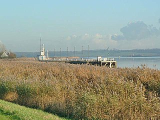
Blacktoft is a village and civil parish in the East Riding of Yorkshire, England. The village is situated on the north bank of the River Ouse, 1 mile (1.6 km) west from where it joins the River Trent and becomes the Humber. It is approximately 6 miles (10 km) east from Howden and 23 miles (37 km) south-east from the county town of York. Blacktoft lies within the Parliamentary constituency of Haltemprice and Howden an area that mainly consists of middle class suburbs, towns and villages. The area is affluent, placed as the 10th most affluent in the country in a 2003 Barclays Private Clients survey, and has one of the highest proportions of owner-occupiers in the country.

North Newbald is a village and former civil parish, now in the parish of Newbald, in the East Riding of Yorkshire, England. The village is situated approximately 13 miles (20 km) north-west of Hull city centre, 3 miles (5 km) north of South Cave and 3.5 miles (6 km) south of Market Weighton. It lies to the east of the A1034 road.

Gembling is a hamlet and former civil parish, now in the parish of Foston, in the East Riding of Yorkshire, England. It is situated approximately 8 miles (13 km) south-west from the coastal resort of Bridlington and 2.5 miles (4 km) north from the village of North Frodingham. In 1931 the parish had a population of 80.

Knedlington is a small hamlet and former civil parish, now in the parish of Asselby, in the East Riding of Yorkshire, England. It is situated approximately 1 mile (1.6 km) west of the market town of Howden and lies to the west of the B1228 road. The M62 motorway is just over 1 mile to the south-east. Village landmarks include Knedlington Manor, Knedlington Hall, and woodland. Knedlington Hall was protected as a Grade II* listed building in 1966. In 1931 the parish had a population of 86.

Faxfleet is a hamlet and former civil parish, now in the parish of Blacktoft, in the East Riding of Yorkshire, England. It is situated approximately 6 miles (10 km) west of Brough, and at the start of the Humber, on the north bank, where the River Ouse and the River Trent meet. In 1931 the parish had a population of 151.
Yokefleet is a hamlet in the East Riding of Yorkshire, England. It forms part of the civil parish of Blacktoft and a very small part of the civil parish of Laxton. It is situated on the north bank of the River Ouse, downstream from York, Selby and Goole.

Rotsea is a hamlet and former civil parish, now in the parish of Hutton Cranswick, in the East Riding of Yorkshire, England. It is situated approximately 4.5 miles (7.2 km) south-east of Driffield and 2.5 miles (4 km) south-west of North Frodingham. In 1931 the parish had a population of 29.

Portington is a hamlet in the East Riding of Yorkshire, England. It is situated approximately 3 miles (5 km) east of Howden and lies 0.5 miles (0.8 km) east of the A614 road.
Newland is a hamlet in the East Riding of Yorkshire, England. It is situated approximately 3 miles (5 km) east of Howden and lies north of the B1230 road and it straddles the M62 motorway. It is served by Eastrington railway station on the Hull to York Line.

Laytham is a village and former civil parish, now in the parish of Foggathorpe, in the East Riding of Yorkshire, England. It is situated approximately 6 miles (9.7 km) north of Howden town centre and 3 miles (5 km) west of Holme-on-Spalding-Moor. In 1931 the parish had a population of 63.

Laxton is a village and civil parish in the East Riding of Yorkshire, England. The village is situated approximately 2 miles (3 km) east from Howden and 19 miles (31 km) south-east from the county town of York.

Eastburn is a hamlet and former civil parish, now in the parish of Kirkburn, in the East Riding of Yorkshire, England. It is situated in the Yorkshire Wolds on the A164 road, approximately 2.5 miles (4 km) south-west of Driffield town centre and 3 miles (5 km) north-west of the village of Hutton Cranswick. In 1931 the parish had a population of 27.
Balkholme is a hamlet and former civil parish, now in the parish of Kilpin and the East Riding of Yorkshire, England. In 1931 the parish had a population of 78.

Kilpin is a village and civil parish in the East Riding of Yorkshire, England. It is situated approximately 1.5 miles (2.4 km) south-east of Howden and 18 miles (29 km) south-east from the county town of York.
Harlthorpe is a hamlet and former civil parish, now in the parish of Foggathorpe, in the East Riding of Yorkshire, England. It is situated approximately 8 miles (13 km) north-east of Selby town centre and 6 miles (9.7 km) north of Howden town centre. It lies on the A163 road. In 1931 the parish had a population of 53.

Gransmoor is a hamlet and former civil parish, now in the parish of Burton Agnes, in the East Riding of Yorkshire, England. It is situated approximately 6 miles (10 km) south-west of the town of Bridlington and 3 miles (5 km) south-east of the village of Burton Agnes. In 1931 the parish had a population of 83.

East Cottingwith is a village and former civil parish, now in the parish of Cottingwith, in the East Riding of Yorkshire, England. It lies on the former Derwent Navigation (canal), and approximately 9 miles (14 km) north-west of the market town of Howden and 7 miles (11 km) south-west of the market town of Pocklington. The village is 1 mile (1.6 km) west of the B1228 road and just east of the River Derwent. In 1931 the civil parish had a population of 185. East Cottingwith was formerly a township and chapelry in the parish of Aughton, from 1866 East Cottingwith was a civil parish in its own right, on 1 April 1935 the civil parish was merged with Storwood to create Cottingwith.

Bolton is a village and former civil parish, now in the parish of Fangfoss, in the East Riding of Yorkshire, England. It is situated approximately 10 miles (16 km) to the east of the city of York and 3 miles (5 km) north-west of the town of Pocklington. In 1931 the parish had a population of 130. Bolton was formerly a township in the parish of Bishop Wilton, from 1866 Bolton was a civil parish in its own right, on 1 April 1935 the parish was abolished and merged with Fangfoss, part also went to form Bishop Wilton.
Bellasize is a hamlet and former civil parish, now in the parish of Blacktoft, in the East Riding of Yorkshire, England. It is situated approximately 5 miles (8 km) east of the market town of Howden. In 1931 the parish had a population of 122.


