Bishopthorpe

Last updated

Bishopthorpe
Entrance to Bishop's Palace Bishopsthorpe - geograph.org.uk - 1057477.jpg
Gateway to Bishopthorpe Palace
North Yorkshire UK location map (2023).svg
Red pog.svg
Bishopthorpe
Location within North Yorkshire
Population3,237 (Census 2011) [1]
OS grid reference SE590473
Civil parish
  • Bishopthorpe
Unitary authority
Ceremonial county
Region
Country England
Sovereign state United Kingdom
Post town YORK
Postcode district YO23
Dialling code 01904
Police North Yorkshire
Fire North Yorkshire
Ambulance Yorkshire
UK Parliament
List of places
UK
England
Yorkshire
53°55′07″N1°06′03″W / 53.918722°N 1.100807°W / 53.918722; -1.100807

Bishopthorpe is a village and civil parish three miles south of York in the City of York unitary authority area and ceremonial county of North Yorkshire, England. Bishopthorpe is close to the River Ouse, and has a population of 3,174, increasing to 3,237 at the 2011 Census. [1] The area of Main Street and the Palace were made a conservation area in 1989 along with other open areas of the village. [2]

Contents

The village was historically part of the West Riding of Yorkshire until 1974. It was then a part of the district of Selby District in North Yorkshire from 1974 until 1996. Since 1996 it has been part of the City of York unitary authority. [3]

It was formerly known as St Andrewthorpe, but in the 13th century, Archbishop Walter de Grey bought the manor house and gave it to the Dean and Chapter of York Minster. [4] This became Bishopthorpe Palace, the residence of the Archbishop of York. Many of the roads in Bishopthorpe are named after past Archbishops.

History

Old St Andrew's Church St Andrew's Old Church, Bishopthorpe - geograph.org.uk - 574437.jpg
Old St Andrew's Church

The village is mentioned in the Domesday Book and referred to as Torp/Thorpe or Badetorps depending on which translation is used. [5] [6] It came to be known as Thorp-super-Usam or Thorpe-on-Ouse in 1194. [7] By 1275 the Earliest written record of the name Bishopthorpe, spelt '"Biscupthorpe"' appears in documents. In 1202, Prior and monks of St. Andrews at Fishergate, built the first church here and dedicated it to their patron saint. The name Thorp-super-Usam therefore gradually superseded by Andrewthorpe or Thorpe St. Andrew. In 1226, Archbishop Walter de Gray bought property which once belonged to the Abbot of Kirkstall Abbey and the Priory of St. Andrews. By the year 1241, Archbishop Gray had built a Manor House and Chapel by the river. He conveyed this property to the Dean and Chapter of York thus ensuring that it remained with successive Archbishops and did not fall into the king's hands during a vacancy.

Bishopthorpe was the site, in 1323, of great council to agree a truce between Edward II and Robert the Bruce, whose forces had been harrying Yorkshire following the Battle of Bannockburn, ending the Scot's Great Raid of 1322. [8] [9]

In 1405, Archbishop Scrope was accused of being a traitor by Henry IV and was beheaded in a field near the nunnery of St Clements, now Clementhorpe. In 1763, Archbishop Drummond transformed the Palace by building the now familiar 'Strawberry Gothick' west front and gatehouse. Controversy surrounding the 1832 Reform Bill saw rioters from York attempt to invade Palace angered by initial lack of support from Archbishop Harcourt.[ citation needed ]

The 1757 Enclosure act saw Common land enclosed thus placing strictures on where local people could graze their animals and affected Bishopthorpe.[ citation needed ]

In 1763, a school was founded by local yeoman, Charles Crosby and supported by the parish. The twenty boys and girls were taught to read and write and "instructed in the principles of the Christian religion." In 1846, Archbishop Harcourt built a new village school. The former school, built in 1763 and situated in School Lane, was used as a girls' school and a house for the master, but was divided into three houses in the 1890s. [10] :38–41

The main line of the North Eastern Railway was being constructed in 1871 and cut through the west end of the parish running east of Bridge Road.

In 1894, Bishorpthorpe became part of the Bishopthorpe Rural District, a rural district which was abolished in 1937 by a County Review Order. In 1895, Bishopthorpe Parish Council [11] was formed.

Bishopthorpe Garth was designed by Walter Brierley in 1908. [12] The War Memorial [13] was erected in 1921 to parish men who made the supreme sacrifice during the First World War.

The Almshouses, built in 1846 by the Archbishop of York Edward Venables-Vernon-Harcourt, were demolished in 1963 due to their deterioration and the need to widen the increasingly busy junction at Sim Balk Lane and Main Street. [10] :5

Governance, demography and economy

Governance

Bishopthorpe lies in the Ward of the same name of Unitary Authority of the City of York. It forms part of the UK Parliamentary Constituency of York Outer. The Ward also includes the nearby Village of Acaster Malbis. As of the 2023 elections it is represented by Councillor Michael Nicholls, Conservative. [14]

Demography

By 1801 the population was 218 and by 1901 it had risen to 439 (104 houses) centred on Main Street and Chantry Lane. J Simpson began building houses in the 1930s. Later developer were Bradley Homes and Shepherd Homes who built on the defunct railway land in the 1980s. [10] :1

In 1971 the village population of 2,350 almost doubles due to house building during the 1960s on the Bradley Estate in Acaster Lane. By 1949, the first council houses, made up of twenty semi-detached dwellings, were built in the village in Maple Avenue. The 2001 census showed that the population was 3,174. There were 1,424 dwellings, of which 33.9% were detached and 62.3% were semi-detached or terraced. House ownership was recorded at 86.9%. The largest Age Group within the population, 29.5%, were between 45 and 64 years old with 25.3% between 25 and 44 years old. Of the population aged between 16 and 74 years old, 64.99% declared they were in some form of employment and 31.1% said they were retired. The 2011 census recorded the population as 3,237. [1]

Economy

Bishopthorpe has been a traditional farming community, though nowadays it serves as a commuter base for workers in nearby York and Leeds. There is a range of retail shops including a Post office.[ citation needed ]

Culture and community

Bishopthorpe Village Hall. Bishopthorpe Village Hall (4th November 2016).jpg
Bishopthorpe Village Hall.

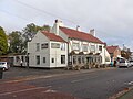
There are three pubs. The Ebor Inn (previously known as the Brown Cow) takes its name from Eboracum , the Roman name for York. The other two are The Marcia (previously known as The Grey Mare) and The Woodman. There is also the Bishopthorpe Sports and Social Club. [15] Between 1949 and 1966, the club hosted the York Model Engineers who installed an open air ride on miniature railway in the grounds. [16]

In 1969, Vernon House, the specially built community centre for Bishopthorpe's elderly people, was officially opened. It provided a place of rest and recreation, and a kitchen and laundry. It was erected at a cost of £7,000 by Tadcaster Rural District Council to complement the area of sheltered accommodation in the village built two years earlier in Maple Avenue and Vernon Close.[ citation needed ]

In 1968, Bishopthorpe Library opened. The former library was held in the air raid shelter which was built on the same site in the Second World War. The site was formerly the village green where fairs were held for the annual two-day Trinity Feast in June.[ citation needed ]

In 1904, the Reading Room funded by Archbishop Maclagan was built as a place of rest and recreation for local men, but without the sale of alcohol. A trust was set up whereby a committee administered the building. In 1947 gas fire heaters (replacing the old open coal fires) were installed and in 1949 further works started that saw a proper stage installed and other internal renovations. It was used by cubs and brownies and other uses included jumble sales and dances, activities that now take place in St Andrew's Hall. [10] :21–22 The Bishopthorpe Women's Institute was formed in 1919 and used it as their base. It was re-furbished in 1950 and was renamed St Andrew's Hall becoming known as the Village Hall.[ citation needed ]

There are 35 plots on the Parish Council run allotments on Acaster Lane [17] and a further 20 privately run plots at Glebe Farm on Moor Lane.

Culture

The first “Bishopthorpe Play” (also known as the Bishopthorpe Pageant) was staged during June 1928 in the grounds of the Bishopthorpe Palace and involved nearly every villager of Bishopthorpe and Acaster Malbis in one way or another. Written Canon F.L. Perkins, the play depicted the history of the 2 villages since AD211 and each performance was watched by hundreds of people. Additional scenes and music were added for the next production in 1930. Further productions were held in 1954, 1956, 1965 and 1970. [10] :49–50

Bishopthorpe features prominently in the novel "The Lost Luggage Porter" by Andrew Martin. In the book the village is known as "Thorpe on Ouse" and is where the main character resides. [18] [19]

Geography and transport

The village is close by the River Ouse, along which are "ings", fields into which the water overflows, most recently in June 2007. In March 1947, the entire length of Main Street was under flood water. [10] :51 The Water Tower in Acaster Lane was built by Archbishop Thomson in 1863. [10] :28

The village is served by two bus services. One route, operated by Harrogate Coach Travel, runs along Tadcaster Road in York, before entering the village along Sim Balk Lane and the other is a direct route along Bishopthorpe Road into York run by First Group. [20]

It is also on the Sustrans Solar System Cycle Track which runs from York to Riccall and is part of the National Cycle Network and Trans-Pennine Way. In 1986/7, the Selby/York Cycle Path opened on the old railway line which had ceased to have railway traffic from 1983 because of the Selby Diversion. [21]

Education and religion

The Archbishop of York's School dates back to 1763 and was built on the site of what is now 8, 10 and 12 School Lane.

Archbishop of York's Junior School. Archbishop of York's Church of England Junior School, Bishopthorpe (4th November 2016).jpg
Archbishop of York's Junior School.

In 1846 The Archbishop of York's CE Primary School was opened, located on Acaster Road. The interior is depicted in a stained glass window in the parish church. Originally 2 classrooms, further classrooms were added in 1893 and 1932. The original school became a girls' school until it was converted into cottages in 1893. In 1967, Archbishop of York's CE Junior School opened across the Appleton Road on the site of the playing fields [22] and serves the communities of Acaster Malbis, Middlethorpe as well the village itself. [10] :38–41

In 1973, Bishopthorpe Infant's School opened on Sim Balk Lane. [10] :38–41

Archbishop Drummond built Old St Andrew's Church on the site of the original (dating back to 1215) in 1768 but its foundations were gradually being washed away by the River Ouse. The third Church of St. Andrews was constructed between 1898 and 1899 on Back Lane (now known as Church Lane), located away from the River Ouse. The tower was added in 1903. [10] :34–37 The architect was C. Hodgson Fowler. [23]

The current Bishopthorpe Methodist Church opened in 1899. The first Methodist Chapel built in 1833 is now private accommodation, Wesley House, situated behind the Supermarket. [10] :33

Sports

Transport

Bus services are provided by First York, Transdev York and Connexionsbuses.

In the early eighteenth century, Lord Wenlock who also owned land at Naburn and Acaster Malbis built a ferry to enable him to visit his estates. It remained in use until 1955. [10] :32 Another passenger ferry provided a regular service between Bishopthorpe and King's Staith in York until the mid-1960s.

Landmarks and notable people

John Sentamu, Archbishop of York, 2005-2020 Archbishop of York John Sentamu.jpg
John Sentamu, Archbishop of York, 2005–2020

Bishopthorpe Palace is a Grade I listed building and is the residence of the Archbishop of York. North of the village is Middlethorpe Hall, a Grade I listed building since 2008 owned by The National Trust and now used as a country house hotel.

Bishopthorpe has a long history of notable ecclesiastical residents. The latest Archbishop of York is Stephen Cottrell, who has been resident since July 2020 when he succeeded John Sentamu. Many of the streets in Bishopthorpe are named after previous Archbishops: for example, Ramsey Avenue (Michael Ramsey, 1956–1961), Maclagan Road (William Maclagan, 1891–1908), Lamplugh Crescent (Thomas Lamplugh, 1688–1691), Coggan Way (Donald Coggan, 1961–1974), Garbett Way (Cyril Garbett, 1942–1955), Temple Road (William Temple, 1929–1942), Lang Road (Cosmo Gordon Lang, 1909 – 1928), Vernon Close (Edward Venables-Vernon, 1808–1847, Drummond Way (Robert Hay Drummond, 1761–1776), Wolsley Drive (Thomas Wolsey, 1514–1530) and De Grey Place (Walter de Gray, 1216–1255). [29]

Related Research Articles

<span class="mw-page-title-main">River Ouse, Yorkshire</span> River in North Yorkshire, England

The River Ouse is a river in North Yorkshire, England. Hydrologically, the river is a continuation of the River Ure, and the combined length of the River Ure and River Ouse makes it, at 129 miles (208 km), the sixth-longest river of the United Kingdom and the longest to flow entirely in one county. The length of the Ouse alone is about 52 miles (84 km) but the total length of the river is disputed.

<span class="mw-page-title-main">Acaster Malbis</span> Village and civil parish in North Yorkshire, England

Acaster Malbis is a village and civil parish in the unitary authority of the City of York, England. It is located on the River Ouse, almost 5 miles (8 km) south of York. Nearby are the villages of Copmanthorpe 2 miles (3.2 km) to the north-west, Bishopthorpe 2 miles to the north and Appleton Roebuck 3.5 miles (6 km) to the south-west. The parish covers an area of about 2,000 acres (810 ha).

<span class="mw-page-title-main">Bishopthorpe Palace</span> Grade I listed building in York, England

Bishopthorpe Palace is a historic house at Bishopthorpe, to the south of York, in the City of York unitary authority and ceremonial county of North Yorkshire, England. It is situated on the River Ouse and is the official residence of the Archbishop of York. In the local area it is known as "the Archbishop's Palace".

<span class="mw-page-title-main">Copmanthorpe</span> Village and civil parish in North Yorkshire, England

Copmanthorpe is a village and civil parish in the City of York in the English county of North Yorkshire, 4 miles (6.4 km) south-west of York, west of Bishopthorpe and close to Acaster Malbis, Askham Bryan and Askham Richard. According to the 2001 census the parish had a population of 4,262, reducing to 4,173 at the 2011 Census.

<span class="mw-page-title-main">Selby</span> Town and civil parish in North Yorkshire, England

Selby is a market town and civil parish in North Yorkshire, England; it is located 12 miles (19.3 km) south of York on the River Ouse. In the 2021 UK Census, it had a population recorded at 19,760.

<span class="mw-page-title-main">Fulford, North Yorkshire</span> Village and civil parish in North Yorkshire, England

Fulford is a historic village and civil parish on the outskirts of York, in the York district, in the ceremonial county of North Yorkshire, England. Fulford is located 2 miles (3 km) to the south of the city, on the east bank of the River Ouse.

<span class="mw-page-title-main">Selby District</span> Former local government district in England

Selby District was a local government district of North Yorkshire, England, from 1974 to 2023. Its council was based in the town of Selby. The district had a population of 83,449 at the 2011 Census. The southernmost district of North Yorkshire, it bordered the City of York unitary authority, the Borough of Harrogate in North Yorkshire, the City of Leeds and City of Wakefield districts in West Yorkshire, the City of Doncaster in South Yorkshire, and the ceremonial county of the East Riding of Yorkshire.

<span class="mw-page-title-main">A64 road</span> Road in West and North Yorkshire, England

The A64 is a major road in North and West Yorkshire, England, which links Leeds, York and Scarborough. The A64 starts as the A64(M) ring road motorway in Leeds, then towards York it becomes a high-quality dual carriageway until it is east of the city, where it becomes a single carriageway for most of its route to Scarborough.

The Ainsty or the Ainsty of York was a historic district of Yorkshire, England, west of the city of York. Originally a wapentake or subdivision of the West Riding of Yorkshire it later had a unique status as a rural area controlled by the corporation of the city.

<span class="mw-page-title-main">Acaster Selby</span> Village and civil parish in North Yorkshire, England

Acaster Selby is a village in North Yorkshire, England. It is part of the joint civil parish with Appleton Roebuck. It is situated about 6 miles (9.7 km) south from York, on the west back of the River Ouse; near the opposite bank is the settlement of Stillingfleet, and 1.3 miles (2.1 km) to the north-west is Appleton Roebuck.

<span class="mw-page-title-main">Appleton Roebuck</span> Village and civil parish in North Yorkshire, England

Appleton Roebuck is a village and civil parish in the former Selby District of North Yorkshire, England. It had a population of 692 according to the 2001 census, increasing to 871 in the 2021 census and including Acaster Selby. The village is about 9 miles (14 km) south-west of York. It covers an area of around 2,900 acres (1,200 ha).

<span class="mw-page-title-main">Naburn</span> Village and civil parish in North Yorkshire, England

Naburn is a small village and civil parish in the unitary authority of the City of York in the ceremonial county of North Yorkshire, England. It lies on the eastern side of the River Ouse about 4 miles (6.4 km) south of York. According to the 2001 census the parish had a population of 470, increasing to 516 at the 2011 census.

<span class="mw-page-title-main">Cawood</span> Village and civil parish in North Yorkshire, England

Cawood is a large village and civil parish in the Selby District of North Yorkshire, England that is notable as the finding-place of the Cawood sword. It was historically part of the West Riding of Yorkshire until 1974.

<span class="mw-page-title-main">York Football League</span> Association football league in North Yorkshire, England

The York Football League is a football competition based in North Yorkshire, England, founded in 1897. Currently it is known under the terms of a sponsorship agreement as the York Minster Engineering Football League. It is a member of the North Riding County Football Association, and the Premier Division sits at level 11 in the English football pyramid.

<span class="mw-page-title-main">Cliffe, Selby</span> Village and civil parish in North Yorkshire, England

Cliffe is a small village and civil parish in North Yorkshire, England. It was historically part of the East Riding of Yorkshire until 1974, but from 1974 to 2023 was in the Selby District of the shire county of North Yorkshire. In 2023 the district was abolished and North Yorkshire became a unitary authority.

<span class="mw-page-title-main">Acaster South Ings</span> Site of Special Scientific Interest in North Yorkshire, England

Acaster South Ings is a Site of Special Scientific Interest, or SSSI, near York, England. It consists of two alluvial flood-meadows, and was designated in 1988 because it supports diverse fauna and flora, some of which is rare in the Vale of York area. One of the rarities is the tansy beetle, which feeds on the leaves of the tansy plant.

<span class="mw-page-title-main">City of York</span> Unitary authority area in North Yorkshire, England

The City of York, offically simply "York", is a unitary authority area with city status in the ceremonial county of North Yorkshire, England.

Royal Air Force Acaster Malbis, or more simply RAF Acaster Malbis, is a former Royal Air Force station located 5.9 miles (9.5 km) south of York city centre and 5.7 miles (9.2 km) east of Tadcaster, North Yorkshire, England. It was developed from a small grass airfield at the beginning of the Second World War and its main use was as a training base for RAF Bomber Command, before being used by RAF Maintenance Command from 1944 until 1957.

Elections to the new City of York unitary authority were held on 4 May 1995, although the new unitary authority wasn't officially created until April 1996. All 53 council seats in the city were up for election and the Labour Party won overall control of the council.

<span class="mw-page-title-main">Bishopthorpe Road</span> Street in York, England

Bishopthorpe Road is a radial route in York, in England, connecting the city centre with the village of Bishopthorpe. It is locally known as Bishy Road.

References

  1. 1 2 3 UK Census (2011). "Local Area Report – Bishopthorpe Parish 2011 (E04010458)". Nomis. Office for National Statistics . Retrieved 19 September 2019.
  2. "Conservation Area – what's that then?". Bishopthorpe@Crossroads. 6 June 2005. Archived from the original on 22 July 2011. Retrieved 25 October 2010.
  3. "History of Bishopthorpe". Vision of Britain. University of Portsmouth. Retrieved 28 November 2020.
  4. "Walter De Grey (c.1188–1255)". Britannia. Archived from the original on 26 December 2010. Retrieved 22 October 2010.
  5. Briggs, Keith. "32434 Domesday Book place-name forms, alphabetic order" (PDF). p. 22. Retrieved 25 October 2010.
  6. Turner, J. Horsfall (1901). Yorkshire place names, as recorded in the Yorkshire Domesday book, 1086. Bingley: Thos. Harrison and Sons. p. 187.
  7. Smith, Julia (2010). "Compound Placenames in English". Medieval Scotland. Retrieved 25 October 2010.
  8. "King Edward II and York". History of York. York Museums Trust. Retrieved 26 October 2010.
  9. Warner, Kathryn (1 May 2009). "With Irreverent Mind: The Adventurous Career Of Henry Beaumont". Edward II. Retrieved 26 October 2010.
  10. 1 2 3 4 5 6 7 8 9 10 11 12 Anon (1988). Bishopthorpe Remembered. Archbishop of York’s C.E. Junior School. ISBN   0951420003.
  11. "Bishopthorpe Parish Council".
  12. Historic England. "Bishopthorpe Garth (1166773)". National Heritage List for England . Retrieved 24 September 2023.
  13. "Spring Clean for the War Memorial". Bishopthorpe History. 8 May 2007. Archived from the original on 6 September 2007.
  14. "Local election results May 2023: Bishopthorpe". City of York Council. 5 May 2023. Retrieved 31 October 2023.
  15. "Bishopthorpe Sports & Social Club".
  16. "YDSME – A Brief History". York City & District Society of Model Engineers.
  17. "Acaster Lane allotments". City of York Council.
  18. Martin, Andrew (2007). The Lost Luggage Porter. London: Faber & Faber. ISBN   9780571219049.
  19. "Bishopthorpe and the Big City Read 2011". bishopthorpe.net. 21 July 2011.
  20. "York Bus Route Map". Travel York.
  21. "The Selby Coalfield". Railway to Greenway.
  22. "Archbishop of York's Church of England Junior School". City of York Council.
  23. Pevsner, Nikolaus; Radcliffe, Enid (1967) [1959]. Yorkshire: The West Riding (2nd ed.). London: Penguin Books.
  24. "Bishopthorpe Bowling Club".
  25. "Bishopthorpe Cricket Club".
  26. "York Leeper Hare Football League".
  27. "Bishopthorpe CFC First". Football Association.
  28. "Bishopthorpe White Rose FC".
  29. "Google Maps".

Commons-logo.svg Media related to Bishopthorpe at Wikimedia Commons