List of crossings of the River Soar

Last updated

Bridge over the River Soar, Abbey Park, Leicester Bridge over the River Soar, Abbey Park (geograph 4718856).jpg
Bridge over the River Soar, Abbey Park, Leicester

This is a list of crossings of the River Soar , the principal river of Leicestershire in the Midlands of England. Listed in the table are those crossings that have been identified downstream of the Soar Brook confluence, near Sharnford, to the last crossing near Ratcliffe-on-Soar upstream of Soar Mouth where the river meets the Trent. [1] [2]

Contents

At Aylestone in Leicester the Grand Union Canal meets the Soar, to form the Soar Navigation. Downstream from this point the navigation and river become intertwined with weirs and bypass channels, one prominent section is the Mile Straight constructed for flood alleviation in the 1890s. It has four listed crossings along its length, including Upperton Road, Mill Lane, Newarke, and West Bridge. The current West Bridge built in 1891, replaced an earlier stone bridge with four arches, that once had a bridge chapel. [3] Crossing the Old Soar nearby, is Bow Bridge, although rebuilt in 1863, the earlier medieval bridge was strongly associated with the local folklore surrounding the death of Richard III. [4]

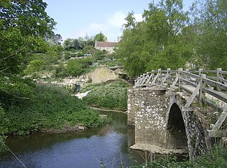
Other notable crossings include the scheduled packhorse bridges at Aylestone and Enderby Mill, with the bridges at Cossington, Barrow, Cotes and Kegworth all being Grade II listed. Near Mountsorrel, a listed red brick bridge from 1860 has been described as “an impressive local landmark.” [5]

Map all coordinates using: OpenStreetMap

Crossings

Key to heritage status
StatusCriteria [6]
IGrade I listed. Bridge of exceptional interest, sometimes considered to be internationally important
II*Grade II* listed. Particularly important bridge of more than special interest
IIGrade II listed. Bridge of national importance and special interest
SM
Scheduled Monument. Nationally important archaeological bridge.
River orderNameImageFrom /To
Coordinates
CarriesDateHeritage
status
Notes & refs
1Footbridge Footbridge over the River Soar (geograph 2582552).jpg Sharnford
52°31′27″N1°16′55″W / 52.52412°N 1.28196°W / 52.52412; -1.28196 (Footbridge)
FootpathFootbridge downstream of Soar Brook confluence. [7]
2Road Bridge Small humpback bridge near Sharnford - geograph.org.uk - 1265883.jpg Sapcote
52°31′29″N1°16′50″W / 52.52461°N 1.28064°W / 52.52461; -1.28064 (Road Bridge)
Main StreetRoad to Frolesworth. [7]
3Stoney Bridge Stoney Bridge crossing the River Soar (geograph 5247946).jpg Sapcote
52°31′56″N1°15′33″W / 52.53219°N 1.25908°W / 52.53219; -1.25908 (Stoney Bridge)
Fosse WayFirst named bridge. [7]
4Road Bridge River Soar - geograph.org.uk - 510782.jpg Broughton Astley
52°32′25″N1°14′53″W / 52.54030°N 1.24810°W / 52.54030; -1.24810 (Road Bridge)
B581Coventry Road. [7]
5Sutton Hill Bridge Broughton Astley
52°32′31″N1°14′52″W / 52.54199°N 1.24790°W / 52.54199; -1.24790 (Sutton Hill Bridge)
B4114Coventry Road. [7]
6Sopers Bridge & Footbridge Bridge over River Soar, near Croft - geograph.org.uk - 215353.jpg Croft
52°32′52″N1°15′27″W / 52.54778°N 1.25741°W / 52.54778; -1.25741 (Sopers Bridge & Footbridge)
FootpathIISopers Bridge is located on an old course of the river. [7] [8]
7Railway bridge Croft
52°33′24″N1°15′03″W / 52.55671°N 1.25097°W / 52.55671; -1.25097 (Railway bridge)
Birmingham to Peterborough Line Stoney Stanton to Croft. [7]
8Croft Bridge Croft Bridge - geograph.org.uk - 1136402.jpg Croft
52°33′31″N1°14′49″W / 52.55864°N 1.24698°W / 52.55864; -1.24698 (Croft Bridge)
Station RoadModern road bridge. [7]
9Footbridge Footbridge across the Soar - geograph.org.uk - 1136338.jpg Croft
52°33′30″N1°14′31″W / 52.55835°N 1.24202°W / 52.55835; -1.24202 (Footbridge)
FootpathNear Croft Quarry. [7]
10Langham Bridge Langham Bridge crossing the River Soar (geograph 5247859).jpg Narborough
52°34′06″N1°13′00″W / 52.56825°N 1.21669°W / 52.56825; -1.21669 (Langham Bridge)
Coventry RoadHistoric bridging point of Fosse Way. [9]
11Railway bridge Narborough
52°34′05″N1°12′42″W / 52.56800°N 1.21168°W / 52.56800; -1.21168 (Railway bridge)
Birmingham to Peterborough Line Upstream from Narborough station. [9]
12Station Road Bridge The River Soar from Station Road, Narborough (geograph 2574787).jpg Littlethorpe
52°34′15″N1°12′12″W / 52.57081°N 1.20342°W / 52.57081; -1.20342 (Station Road Bridge)
Station RoadNear Narborough Station. [10]
13M1 Bridge M1 Motorway near Littlethorpe - geograph.org.uk - 509621.jpg Narborough
52°34′17″N1°11′36″W / 52.57136°N 1.19342°W / 52.57136; -1.19342 (M1 Bridge)
M1 Motorway Motorway bridge. [10]
14Railway bridge Enderby
52°34′33″N1°11′19″W / 52.57592°N 1.18856°W / 52.57592; -1.18856 (Railway bridge)
Birmingham to Peterborough Line Downstream of M1. [10]
15Enderby Mill Bridge Enderby Mill Bridge (geograph 5272112).jpg Enderby
52°34′50″N1°11′23″W / 52.58069°N 1.18962°W / 52.58069; -1.18962 (Enderby Mill Bridge)
Footpath15th centurySMScheduled bridge with adjacent footbridge. [10] [11]
16Enderby Bridge Enderby Bridge crossing the River Soar (geograph 5271960).jpg Enderby
52°34′53″N1°11′19″W / 52.58145°N 1.18858°W / 52.58145; -1.18858 (Enderby Bridge)
Enderby RdModern road bridge. [10]
17Soar Valley Way Soar Valley Road Bridge. - geograph.org.uk - 366176.jpg Enderby
52°35′45″N1°10′12″W / 52.59594°N 1.17007°W / 52.59594; -1.17007 (Soar Valley Way)
A563Dual carriageway. [12]
18Aylestone Packhorse Bridge Aylestone Packhorse Bridge detail.jpg Aylestone
52°36′12″N1°09′46″W / 52.60326°N 1.16288°W / 52.60326; -1.16288 (Aylestone Packhorse Bridge)
Footpath15th centuryII & SMScheduled packhorse bridge. [12] [13]
19Footbridge Three bridges along the River Soar (geograph 3327254).jpg Aylestone
52°36′12″N1°09′44″W / 52.60338°N 1.16229°W / 52.60338; -1.16229 (Footbridge)
TowpathCrosses Soar where it joins with canal. [12]
20Footbridge Bridge across the Grand Union Canal - geograph.org.uk - 1166081.jpg Aylestone
52°36′14″N1°09′40″W / 52.60383°N 1.16117°W / 52.60383; -1.16117 (Footbridge)
Grand Central WayFormer Great Central Railway. [12]
21Freestone Bridge Bridge 106 - Freestone Bridge - geograph.org.uk - 1166078.jpg Aylestone
52°36′17″N1°09′34″W / 52.60466°N 1.15944°W / 52.60466; -1.15944 (Freestone Bridge)
Braunstone Lane EastBraunstone Lane East. [12]
22Parsons Bridge Parsons Bridge - geograph.org.uk - 1166070.jpg Aylestone
52°36′25″N1°09′13″W / 52.60698°N 1.15359°W / 52.60698; -1.15359 (Parsons Bridge)
Canal StreetAccess road to Aylestone Meadows. [12]
23Aylestone Mill Road to the car park at Riverside Park (geograph 2792644).jpg Aylestone
52°36′36″N1°08′47″W / 52.60995°N 1.14646°W / 52.60995; -1.14646 (Aylestone Mill)
Aylestone MillAccess road to Aylestone Meadows. [12]
24Access bridge Entrance to small industrial estate off Aylestone Road (geograph 5018198).jpg Aylestone
52°36′40″N1°08′36″W / 52.61101°N 1.14346°W / 52.61101; -1.14346 (Access bridge)
Access roadAccess road to industrial estate. [14]
25Twelve Arches railway viaduct Twelve Arches Bridge across the Grand Union Canal in Leicester. - geograph.org.uk - 377431.jpg Westcotes
52°37′12″N1°08′48″W / 52.61987°N 1.14656°W / 52.61987; -1.14656 (Twelve Arches railway viaduct)
Leicester–Burton upon Trent line Upstream of Freemans Weir. [15]
26Footbridge across Old Soar Footbridge across the Old River Soar, Leicester (geograph 5540019).jpg Bede Island
52°37′28″N1°08′37″W / 52.62435°N 1.14354°W / 52.62435; -1.14354 (Footbridge across Old Soar)
TowpathOld River Soar - first crossing. [16]
27Watkin Road Bridge Former Grand Union Canal (geograph 2116304).jpg Bede Island
52°37′31″N1°08′41″W / 52.62534°N 1.14485°W / 52.62534; -1.14485 (Watkin Road Bridge)
Access roadOld River Soar. [15]
28Upperton Road Bridge Upperton Road bridge crossing the Old River Soar (geograph 5249976).jpg Bede Island
52°37′33″N1°08′43″W / 52.62572°N 1.14532°W / 52.62572; -1.14532 (Upperton Road Bridge)
Upperton RoadOld River Soar. [15]
29Great Central Way footbridge Old railway bridges, Leicester (geograph 2304111).jpg Bede Island
52°37′36″N1°08′47″W / 52.62661°N 1.14641°W / 52.62661; -1.14641 (Great Central Way footbridge)
Great Central WayFormer railway bridge over the Old River Soar - a disused bridge is adjacent. [15]
30Footbridge Bede Island
52°37′41″N1°08′47″W / 52.62816°N 1.14639°W / 52.62816; -1.14639 (Footbridge)
FootpathOld Soar - Modern Footbridge. [15]
31Western Boulevard Old River Soar in Leicester (geograph 4000213).jpg Bede Island
52°37′55″N1°08′39″W / 52.63194°N 1.14426°W / 52.63194; -1.14426 (Western Boulevard)
RoadOld Soar, site of demolished Braunstone Gate Bridge. [15]
32Bow Bridge Bow Bridge crossing the Old River Soar (geograph 4364448).jpg Bede Island
52°38′02″N1°08′39″W / 52.63397°N 1.14425°W / 52.63397; -1.14425 (Bow Bridge)
A471863Old Soar-St Augustine Road bridge. [15]
33Upperton Road Bridge Canal Bridge (geograph 2116322).jpg Mile Straight
52°37′32″N1°08′35″W / 52.62562°N 1.14310°W / 52.62562; -1.14310 (Upperton Road Bridge)
Upperton Road1890IIOne of four listed bridges on the Mile Straight. [16] [17]
34Swan Bridge Bridge over the Grand Union Canal, Leicester (geograph 3855742).jpg Mile Straight
52°37′34″N1°08′35″W / 52.62604°N 1.14302°W / 52.62604; -1.14302 (Swan Bridge)
Upperton Road109A Eastbound Modern bridge. [16]
35Mill Lane bridge Mill Lane Bridge in Leicester (geograph 5908873).jpg Mile Straight
52°37′44″N1°08′33″W / 52.62875°N 1.14260°W / 52.62875; -1.14260 (Mill Lane bridge)
Mill Lane1890IIOne of four listed bridges on the Mile Straight. [16] [18]
36Newarke Bridge Newarke Bridge in Leicester (geograph 5908968).jpg Mile Straight
52°37′52″N1°08′32″W / 52.63110°N 1.14226°W / 52.63110; -1.14226 (Newarke Bridge)
The Newarke1898IIOne of four listed bridges on the Mile Straight. [16] [19]
37Footbridge Grand Union Canal in Leicester (geograph 5909047).jpg Mile Straight
52°37′57″N1°08′31″W / 52.63262°N 1.14205°W / 52.63262; -1.14205 (Footbridge)
FootpathBridge 2A. [16]
38West Bridge West Bridge in Leicester (geograph 5909539).jpg Mile Straight
52°38′01″N1°08′32″W / 52.63362°N 1.14219°W / 52.63362; -1.14219 (West Bridge)
A471891IIHistoric bridging point, one of four listed bridges on the Mile Straight. [16] [20]
39West Bridge West Bridge crossing the Grand Union Canal (geograph 4364490).jpg Mile Straight
52°38′02″N1°08′33″W / 52.63380°N 1.14239°W / 52.63380; -1.14239 (West Bridge)
A47Eastbound Modern. [16]
40Footbridge Footbridge and weir across the Grand Union Canal in Leicester. - geograph.org.uk - 377468.jpg Westcotes
52°38′15″N1°08′42″W / 52.63761°N 1.14498°W / 52.63761; -1.14498 (Footbridge)
FootpathEvans Weir. [15]
41Soar Lane bridge Soar Lane Bridge crossing the River Soar (geograph 4314624).jpg Westcotes
52°38′18″N1°08′44″W / 52.63821°N 1.14546°W / 52.63821; -1.14546 (Soar Lane bridge)
Soar LaneWest side of Soar island. [15]
42Footbridge Grand Union Canal, Leicester - geograph.org.uk - 586165.jpg Soar Island
52°38′23″N1°08′44″W / 52.63979°N 1.14566°W / 52.63979; -1.14566 (Footbridge)
TowpathBetween Soar and Frog Island. [21]
43North Bridge Derelict building at Frog Island, Leicester (geograph 3889100).jpg Frog Island
52°38′35″N1°08′39″W / 52.64293°N 1.14414°W / 52.64293; -1.14414 (North Bridge)
A50Links Woodgate to Frog Island. [22]
44St Margarets Way St Margarets Way Bridge over River Soar (geograph 5199893).jpg Frog Island
52°38′39″N1°08′26″W / 52.64421°N 1.14053°W / 52.64421; -1.14053 (St Margarets Way)
A6Dual bridges. [22]
45Footbridge Abbey Park footbridge (geograph 5809974).jpg Abbey Park
52°38′40″N1°08′23″W / 52.64456°N 1.13973°W / 52.64456; -1.13973 (Footbridge)
FootpathConcrete footbridge. [22]
46Abbey Park Bridge Bridge - panoramio - Tanya Dedyukhina (2).jpg Abbey Park
52°38′49″N1°08′13″W / 52.64688°N 1.13685°W / 52.64688; -1.13685 (Abbey Park Bridge)
FootpathOrnamental footbridge. [22]
47Abbey Corner Bridge Abbey Park Rd bridge - panoramio.jpg Abbey Park
52°38′57″N1°08′03″W / 52.64904°N 1.13423°W / 52.64904; -1.13423 (Abbey Corner Bridge)
Abbey Park Road1878IIAbbey Park Road Bridge. [22] [23]
48Abbey Meadows footbridge New pedestrian footbridge (under construction) (geograph 3757586).jpg Abbey Meadows
52°39′10″N1°07′57″W / 52.65265°N 1.13237°W / 52.65265; -1.13237 (Abbey Meadows footbridge)
Footpath2013Wolsey Point to National Space Centre
49Holden Street footbridge Soar Valley - panoramio - Tanya Dedyukhina (8).jpg Belgrave
52°39′20″N1°07′32″W / 52.65551°N 1.12563°W / 52.65551; -1.12563 (Holden Street footbridge)
Footpath1985Refurbished in 2015. [22]
50Belgrave Bridge Thurcaston Road Bridge - panoramio.jpg Belgrave
52°39′39″N1°07′42″W / 52.66082°N 1.12833°W / 52.66082; -1.12833 (Belgrave Bridge)
Thurcaston RoadProbable 15th centuryIIThurcaston Road Bridge (Old Bridge). [22] [24]
51New Bridge Soar Valley - panoramio.jpg Belgrave
52°39′47″N1°07′37″W / 52.66297°N 1.12685°W / 52.66297; -1.12685 (New Bridge)
Loughborough Road1834IILoughborough Road Bridge. [22] [25]
52Watermead Bridge Watermead Bridge, Leicester - geograph.org.uk - 473515.jpg Rushey Mead
52°40′00″N1°07′06″W / 52.66664°N 1.11827°W / 52.66664; -1.11827 (Watermead Bridge)
Watermead WayA563. [22]
53Birstall weir footbridge Soar Valley - panoramio - Tanya Dedyukhina (9).jpg Rushey Mead
52°40′20″N1°06′51″W / 52.67210°N 1.11430°W / 52.67210; -1.11430 (Birstall weir footbridge)
TowpathCurved weir and footbridge. [26]
54Footbridge Birstall
52°40′22″N1°06′50″W / 52.67265°N 1.11380°W / 52.67265; -1.11380 (Footbridge)
FootpathNear Birstall Lock. [26]
55Birstall Lock footbridge An overflowing Birstall Lock (geograph 3254136).jpg Birstall
52°40′26″N1°06′58″W / 52.67378°N 1.11620°W / 52.67378; -1.11620 (Birstall Lock footbridge)
FootpathOne of a number of bridges at Birstall Lock. [26]
56Birstall Lock footbridge Footbridge across the River Soar by Birstall Lock (geograph 5973600).jpg Birstall
52°40′26″N1°06′57″W / 52.67381°N 1.11596°W / 52.67381; -1.11596 (Birstall Lock footbridge)
FootpathBridge 14c. [26]
57Footbridge Flooded footbridge on the Grand Union Canal (geograph 3254111).jpg Birstall
52°40′29″N1°07′01″W / 52.67459°N 1.11690°W / 52.67459; -1.11690 (Footbridge)
TowpathWhite Horse Lane. [27]
58Footbridge River Soar west of Thurmaston, Leicestershire (geograph 5974851).jpg Watermead Country Park
52°40′43″N1°06′09″W / 52.67865°N 1.10240°W / 52.67865; -1.10240 (Footbridge)
TowpathBridge 16B, Thurmaston Weir. [27]
59Footbridge River footbridge (geograph 2652748).jpg Watermead Country Park
52°40′47″N1°06′07″W / 52.67968°N 1.10195°W / 52.67968; -1.10195 (Footbridge)
TowpathDownstream of Thurmaston Lock. [27]
60Footbridge River Soar and canal near Thurmaston, Leicestershire (geograph 5975485).jpg Watermead Country Park
52°41′01″N1°06′04″W / 52.68362°N 1.10116°W / 52.68362; -1.10116 (Footbridge)
TowpathCrosses Soar where it splits with canal. [27]
61Footbridge River Soar Bridge at King Lears Lake,Watermead Park - geograph.org.uk - 584313.jpg Watermead Country Park
52°41′08″N1°06′21″W / 52.68564°N 1.10588°W / 52.68564; -1.10588 (Footbridge)
FootpathKing Lears Lake. [27]
62Pochin Bridge The A46 crossing the River Soar - geograph.org.uk - 853370.jpg Wanlip
52°41′48″N1°06′30″W / 52.69668°N 1.10837°W / 52.69668; -1.10837 (Pochin Bridge)
A46Leicester Western Bypass. [28]
63Cossington footbridge River Soar north-east of Rothley in Leicestershire (geograph 5978086).jpg Cossington
52°42′34″N1°07′12″W / 52.70954°N 1.12005°W / 52.70954; -1.12005 (Cossington footbridge)
TowpathAbove Cossington Lock. [2]
64Cossington Bridge Cossington Bridge - geograph.org.uk - 647145.jpg Cossington
52°42′41″N1°07′15″W / 52.71130°N 1.12090°W / 52.71130; -1.12090 (Cossington Bridge)
Cossington Lanec. 1800IIListed bridge. [29]
65Sileby Lock footbridges Footbridge across the weir near Sileby Mill, Leicestershire (geograph 5981631).jpg Sileby
52°43′38″N1°07′26″W / 52.72724°N 1.12400°W / 52.72724; -1.12400 (Sileby Lock footbridges)
TowpathSeries of three footbridges. [2]
66Sileby Mill footbridge Footbridge over the Soar - geograph.org.uk - 677098.jpg Sileby
52°43′42″N1°07′32″W / 52.72832°N 1.12547°W / 52.72832; -1.12547 (Sileby Mill footbridge)
TowpathSileby Mill. [2]
67A6 bridge A6 Road Bridge (geograph 2351687).jpg Mountsorrel
52°43′56″N1°08′04″W / 52.73220°N 1.13450°W / 52.73220; -1.13450 (A6 bridge)
A6One of four A6 crossings. [2]
68Sileby Lane bridge River Soar (geograph 5037479).jpg Mountsorrel
52°43′52″N1°08′25″W / 52.73119°N 1.14021°W / 52.73119; -1.14021 (Sileby Lane bridge)
Sileby LaneEast of Mountsorrel. [2]
69Mountsorrel mineral railway bridge Mountsorrel Mineral Railway Bridge Soar Navigation (geograph 3167651).jpg Mountsorrel
52°43′59″N1°08′35″W / 52.73294°N 1.14292°W / 52.73294; -1.14292 (Mountsorrel mineral railway bridge)
Conveyor1860II1860 bridge - Brick bridge. [5]
70Mountsorrel turnover Bridge 26 Footbridge across the Grand Union Canal - geograph.org.uk - 516887.jpg Mountsorrel
52°44′07″N1°08′40″W / 52.73541°N 1.14451°W / 52.73541; -1.14451 (Mountsorrel turnover Bridge 26)
TowpathCarries towpath from one bank to the other. [2]
71A6 bridge A6 Canal Bridge - geograph.org.uk - 516875.jpg Mountsorrel
52°44′22″N1°08′33″W / 52.73934°N 1.14263°W / 52.73934; -1.14263 (A6 bridge)
A6One of four A6 crossings. [2]
72Footbridge A weir and footbridge at Barrow-upon-Soar (geograph 5553820).jpg Barrow upon Soar
52°44′45″N1°08′40″W / 52.74573°N 1.14457°W / 52.74573; -1.14457 (Footbridge)
TowpathCrosses over weir. [2]
73Footbridge Barrow upon Soar
52°44′37″N1°08′47″W / 52.74367°N 1.14652°W / 52.74367; -1.14652 (Footbridge)
FootpathBetween Barrow and A6. [2]
74A6 bridge The A6 crosses the River Soar (geograph 4635581).jpg Barrow upon Soar
52°44′33″N1°08′52″W / 52.74240°N 1.14790°W / 52.74240; -1.14790 (A6 bridge)
A6One of four A6 crossings. [2]
75A6 bridge A6 Road Bridge (geograph 2351687).jpg Quorn
52°44′54″N1°09′31″W / 52.74830°N 1.15861°W / 52.74830; -1.15861 (A6 bridge)
A6One of four A6 crossings. [2]
76Mill Lane bridge Navigationbridgebarrow.JPG Barrow upon Soar
52°44′45″N1°08′50″W / 52.74590°N 1.14733°W / 52.74590; -1.14733 (Mill Lane bridge)
Mill LaneNavigation Inn. [2]
77Barrow Lock bdg Barrow Lock Bridge - geograph.org.uk - 687806.jpg Barrow upon Soar
52°44′59″N1°09′10″W / 52.74981°N 1.15265°W / 52.74981; -1.15265 (Barrow Lock bdg)
Proctors Park RoadMinor road. [2]
78Barrow Road Bridge Barrow upon Soar bridge - geograph.org.uk - 516703.jpg Barrow upon Soar
52°45′03″N1°09′11″W / 52.75081°N 1.15303°W / 52.75081; -1.15303 (Barrow Road Bridge)
Bridge Street1845IIListed bridge. [30]
79Pillings Lock rail bdg River Soar near Pilling's Lock - geograph.org.uk - 695023.jpg Barrow upon Soar
52°45′35″N1°09′49″W / 52.75970°N 1.16350°W / 52.75970; -1.16350 (Pillings Lock rail bdg)
Midland Main Line Railway bridge. [2]
80Cotes Bridge Cotes Bridge, Loughborough - geograph.org.uk - 8685.jpg Cotes
52°46′49″N1°10′49″W / 52.78026°N 1.18025°W / 52.78026; -1.18025 (Cotes Bridge)
A6018th centuryIINottingham Road. [31]
81Footbridge Footbridge over the Soar, Stanford-on-Soar - geograph.org.uk - 695559.jpg Cotes
52°47′22″N1°11′41″W / 52.78939°N 1.19466°W / 52.78939; -1.19466 (Footbridge)
FootpathOne of two footbridges at this point. [2]
82Footbridge Loughborough footbridge over the Soar - geograph.org.uk - 1296175.jpg Cotes
52°47′19″N1°11′43″W / 52.78857°N 1.19518°W / 52.78857; -1.19518 (Footbridge)
FootpathOne of two footbridges at this point. [2]
83 Stanford Viaduct Viaduct at Stanford on Soar.jpg Stanford on Soar
52°47′25″N1°11′51″W / 52.79030°N 1.19740°W / 52.79030; -1.19740 (Stanford Viaduct)
Great Central Railway (heritage railway) 1899Skewed central arches. [2]
84Meadow Lane Bridge County boundary near Stanford on Soar, Leics (geograph 4240439).jpg Stanford on Soar
52°47′26″N1°11′55″W / 52.79063°N 1.19849°W / 52.79063; -1.19849 (Meadow Lane Bridge)
Meadow LaneMinor road. [2]
85Railway bridge Midland Main Line crosses the River Soar (geograph 3302908).jpg Stanford on Soar
52°47′37″N1°12′59″W / 52.79370°N 1.21650°W / 52.79370; -1.21650 (Railway bridge)
Midland Main Line Major rail bridge. [2]
86Zouch footbridges Zouch Weir - geograph.org.uk - 716040.jpg Zouch
52°48′22″N1°14′45″W / 52.80618°N 1.24575°W / 52.80618; -1.24575 (Zouch footbridges)
FootpathA series of three footbridges over the weirs at Zouch. [2]
87Zouch Bridge River Soar and the A6006 Zouch Bridge (geograph-4505839).jpg Zouch
52°48′16″N1°15′22″W / 52.80448°N 1.25606°W / 52.80448; -1.25606 (Zouch Bridge)
A6006County Bridge, due for replacement. [2]
88Kegworth Bridge Bridge over the Soar, Kegworth - geograph.org.uk - 738129.jpg Kegworth
52°50′25″N1°16′09″W / 52.84034°N 1.26906°W / 52.84034; -1.26906 (Kegworth Bridge)
Station Road1785IIGrade II bridge, widened in 1937. [32]
89Kegworth footbridge Footbridge over the River Soar - geograph.org.uk - 715777.jpg Kegworth
52°50′31″N1°16′01″W / 52.84183°N 1.26706°W / 52.84183; -1.26706 (Kegworth footbridge)
TowpathCarries towpath across the river. [2]
90A453 Bridge A453 crossing the Soar - geograph.org.uk - 739558.jpg Ratcliffe-on-Soar
52°51′28″N1°15′53″W / 52.85784°N 1.26459°W / 52.85784; -1.26459 (A453 Bridge)
A453Remembrance Way. [2]
91Ratcliffe on Soar Ford Ford on the Soar at Ratcliffe on Soar (geograph 2980140).jpg Ratcliffe-on-Soar
52°51′33″N1°15′55″W / 52.85903°N 1.26538°W / 52.85903; -1.26538 (Ratcliffe on Soar Ford)
BridlewayFord across the Soar. [2]
92Soar Mouth Soar Mouth - geograph.org.uk - 687362.jpg Ratcliffe-on-Soar
52°52′23″N1°16′06″W / 52.87313°N 1.26829°W / 52.87313; -1.26829 (Soar Mouth)
Trent Lock ferryIn the 1900s a ferry crossed from the Soar to Trent Lock at the Trent confluence, carrying horses and passengers. [33] [2]

Bibliography

Related Research Articles

<span class="mw-page-title-main">Leicester</span> City and unitary authority area in England

Leicester is a city, unitary authority area, unparished area and the county town of Leicestershire in the East Midlands of England. It is the largest city in the East Midlands. Its population was 368,600 in 2021, increased by 38,800 from around 329,800 in 2011. The greater Leicester urban area had a population of 559,017 in 2021, making it the 11th most populous in England, and the 13th most populous in the United Kingdom.

<span class="mw-page-title-main">River Soar</span> River in Warwickshire and Leicestershire, England

The River Soar is a major tributary of the River Trent in the English East Midlands and is the principal river of Leicestershire. The source of the river is midway between Hinckley and Lutterworth. The river then flows north through Leicester, where it is joined by the Grand Union Canal. Continuing on through the Leicestershire Soar Valley, it passes Loughborough and Kegworth until it reaches the Trent at the county boundary. In the 18th century, the Soar was made navigable, initially between Loughborough and the Trent, and then through to Leicester. It was not until the early 19th century that it was linked by the Grand Union Canal to the wider network to the south and to London.

<span class="mw-page-title-main">River Blythe</span> River in Warwickshire and the West Midlands, England

The River Blythe flows through the English Midlands from central Warwickshire, through the Borough of Solihull and on to Coleshill in north Warwickshire. It runs along the Meriden Gap in the Midlands Plateau, is fed by the River Cole and is a tributary of the River Tame beside the West Midland Bird Club's Ladywalk reserve. This then joins the River Trent, whose waters reach the North Sea via the Humber Estuary.

<span class="mw-page-title-main">Aylestone</span> Human settlement in England

Aylestone is a suburb of Leicester, England, southwest of the city centre and to the east of the River Soar. It was formerly a separate village, but the growth of the city since the Leicester Extension Act of 1891 incorporated Aylestone into the Borough of Leicester and it is now part of the suburban area.

<span class="mw-page-title-main">Packhorse bridge</span> Type of bridge

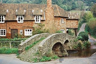
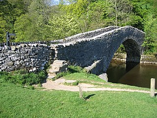
A packhorse bridge is a bridge intended to carry packhorses across a river or stream. Typically a packhorse bridge consists of one or more narrow masonry arches, and has low parapets so as not to interfere with the panniers borne by the horses. Multi-arched examples sometimes have triangular cutwaters that are extended upward to form pedestrian refuges.

<span class="mw-page-title-main">River Frome, Somerset</span> River in Somerset, England

The River Frome is a river in Somerset, England. It rises near Bungalow Farm on Cannwood Lane, south-west of Witham Friary, flows north through Blatchbridge to the town of Frome, and continues in a generally northerly direction passing between the eastern edge of the Mendip Hills and Trowbridge before joining the Bristol Avon at Freshford, below Bradford on Avon.

<span class="mw-page-title-main">Sileby</span> Human settlement in England

Sileby is a former industrial village and civil parish in the Soar Valley in the Charnwood borough of Leicestershire, England. It is located between Leicester and Loughborough. The village is close to Barrow upon Soar, Mountsorrel, Ratcliffe-on-the-Wreake, Seagrave and Cossington. The population of the civil parish at the 2011 census was 7,835.

<span class="mw-page-title-main">Allerford</span> Human settlement in England

Allerford is a village in the county of Somerset, England, located within Exmoor National Park, and is part of the parish of Selworthy in the district of Somerset West and Taunton. It appears in Domesday Book as "Alresford – forda Ralph de Limesy Mill".

<span class="mw-page-title-main">Essex Bridge, Staffordshire</span>

Essex Bridge is a Grade I listed packhorse bridge over the River Trent near Great Haywood, Staffordshire, England.

<span class="mw-page-title-main">Tellisford</span> Human settlement in England

Tellisford is a village and civil parish 6 miles (10 km) north-east of Frome in the Mendip district of Somerset, England. The parish includes the village of Woolverton.

<span class="mw-page-title-main">Frog Island, Leicester</span>

Frog Island is an inner city area of Leicester, England, so named because it lies between the River Soar and the Soar Navigation. Frog Island is adjacent to the Woodgate area to the north, and Northgates to the South. The population of the island was at the 2011 census in the Abbey ward of Leicester City Council.

<span class="mw-page-title-main">Mountsorrel Railway</span> Heritage railway in Leicestershire

The Mountsorrel Railway was a network of industrial railway lines that served the granite quarries which dominate the Leicestershire village of Mountsorrel. After being closed in the 1950s, a section was reopened in 2015 as a heritage line run by Mountsorrel & Rothley Community Heritage Centre.

There are ten scheduled monuments in Leicester. These range from the Roman Jewry Wall and Raw Dykes to the medieval Leicester Castle and the early modern King William's Bridge. Several of the scheduled sites have a wide area protecting more than one feature. Seven of the fourteen Grade I listed buildings in Leicester are within the three most central scheduled areas.

<span class="mw-page-title-main">Aylestone Meadows</span>

Aylestone Meadows is an 8.8-hectare (22-acre) Local Nature Reserve in Leicester, England, United Kingdom. It is owned and managed by Leicester City Council.

<span class="mw-page-title-main">Winster, Cumbria</span>

Winster is a village in the South Lakeland District of Cumbria, in North West England. Historically within the county of Westmorland, it is situated less than two miles east of Windermere, England's largest natural lake. The village is within the Lake District National Park. The village has a pub, the Brown Horse Inn, an 1850s coaching inn.

<span class="mw-page-title-main">Stainforth Bridge</span> Packhorse bridge in North Yorkshire, England

Stainforth Bridge, is a 17th century, arched packhorse bridge over the River Ribble in Stainforth, North Yorkshire, England. The bridge was formerly on the main packhorse road between York and Lancaster, which has been superseded by later roads. It was in private ownership until the 1930s, when it was taken on by the National Trust. It is now a grade II listed structure and provides access to Stainforth Force, which is just below the bridge.

<span class="mw-page-title-main">Hampton in Arden packhorse bridge</span> Bridge in Hampton in Arden, England

Hampton in Arden packhorse bridge crosses the River Blythe near Hampton in Arden in the West Midlands of England, between Birmingham and Coventry. Dating from the 15th century, it is the only bridge of its kind in the area now covered by the West Midlands, and is a grade II* listed building and a scheduled monument.

References

  1. A-Z 1996, pp. 6–51.
  2. 1 2 3 4 5 6 7 8 9 10 11 12 13 14 15 16 17 18 19 20 21 22 23 24 25 26 129 Nottingham and Loughborough (Map). 1:50,000. OS Landranger Map Series. Ordnance Survey. 2004. ISBN   9780319 22879 1.
  3. Jervoise, E. (1932). The Ancient Bridges of Mid and Eastern England. Read Books Limited. pp. 28–. ISBN   978-1-4733-4079-4.
  4. "Bow Bridge". Leicester City Council. Retrieved 10 February 2019.
  5. 1 2 Historic England. "Mountsorrel mineral railway bridge (1287391)". National Heritage List for England . Retrieved 10 February 2019.
  6. Listed Buildings, English Heritage, archived from the original on 22 December 2012, retrieved 22 April 2011
  7. 1 2 3 4 5 6 7 8 9 A-Z 1996, p. 51.
  8. Historic England. "Sopers Bridge (1074692)". National Heritage List for England . Retrieved 10 February 2019.
  9. 1 2 A-Z 1996, p. 42.
  10. 1 2 3 4 5 A-Z 1996, p. 43.
  11. Historic England. "Enderby Mill Bridge (1005083)". National Heritage List for England . Retrieved 10 February 2019.
  12. 1 2 3 4 5 6 7 A-Z 1996, p. 35.
  13. Historic England. "Aylestone packhorse bridge (1074055)". National Heritage List for England . Retrieved 10 February 2019.
  14. A-Z 1996, p. 36.
  15. 1 2 3 4 5 6 7 8 9 A-Z 1996, p. 27.
  16. 1 2 3 4 5 6 7 8 A-Z 1996, p. 28.
  17. Historic England. "Upperton Road Bridge (1074785)". National Heritage List for England . Retrieved 10 February 2019.
  18. Historic England. "Mill Lane (1184807)". National Heritage List for England . Retrieved 10 February 2019.
  19. Historic England. "Newarke Bridge (1074794)". National Heritage List for England . Retrieved 10 February 2019.
  20. Historic England. "West Bridge (1074789)". National Heritage List for England . Retrieved 10 February 2019.
  21. A-Z 1996, p. 19.
  22. 1 2 3 4 5 6 7 8 9 A-Z 1996, p. 20.
  23. Historic England. "Abbey Corner Bridge (1387174)". National Heritage List for England . Retrieved 10 February 2019.
  24. Historic England. "Belgrave Bridge (1299667)". National Heritage List for England . Retrieved 10 February 2019.
  25. Historic England. "NewBridge (1387173)". National Heritage List for England . Retrieved 10 February 2019.
  26. 1 2 3 4 A-Z 1996, p. 13.
  27. 1 2 3 4 5 A-Z 1996, p. 14.
  28. A-Z 1996, p. 6.
  29. Historic England. "Cossington Bridge (1287390)". National Heritage List for England . Retrieved 10 February 2019.
  30. Historic England. "Barrow Road Bridge (1074588)". National Heritage List for England . Retrieved 10 February 2019.
  31. Historic England. "Cotes Bridge (1074530)". National Heritage List for England . Retrieved 10 February 2019.
  32. Historic England. "Kegworth Bridge (1068673)". National Heritage List for England . Retrieved 10 February 2019.
    • Taylor, Mike (2000). The River Trent Navigation. Tempus Publishing. p. 113. ISBN   0-7524-1743-6.