A mountain is an elevated portion of the Earth's crust, generally with steep sides that show significant exposed bedrock. Although definitions vary, a mountain may differ from a plateau in having a limited summit area, and is usually higher than a hill, typically rising at least 300 metres (980 ft) above the surrounding land. A few mountains are isolated summits, but most occur in mountain ranges.

Mount Everest, known locally as Sagarmatha or Qomolangma, is Earth's highest mountain above sea level, located in the Mahalangur Himal sub-range of the Himalayas. The China–Nepal border runs across its summit point. Its elevation of 8,848.86 m was most recently established in 2020 by the Chinese and Nepali authorities.

Sierra Nevada is a mountain range in the Andalusian province of Granada in Spain. It contains the highest point of continental Spain: Mulhacén, at 3,479 metres (11,414 ft) above sea level.

Aconcagua is a mountain in the Principal Cordillera of the Andes mountain range, in Mendoza Province, Argentina. It is the highest mountain in the Americas, the highest outside Asia, and the highest in both the Western Hemisphere and the Southern Hemisphere with a summit elevation of 6,961 metres (22,838 ft). Despite its impressive size and stature, it is only the 189th highest mountain in the world. It lies 112 kilometres northwest of the provincial capital, the city of Mendoza, about five kilometres from San Juan Province, and 15 km (9 mi) from Argentina's border with Chile. The mountain is one of the Seven Summits of the seven continents.
The Seven Summits are the highest mountains on each of the seven traditional continents. On 30 April 1985, Richard Bass became the first climber to reach the summit of all seven.

Ushuaia is the capital of Tierra del Fuego, Antártida e Islas del Atlántico Sur Province, Argentina. With a population of 82,615 and a location below the 54th parallel south latitude, Ushuaia claims the title of world's southernmost city.

Chimborazo is a stratovolcano situated in Ecuador in the Cordillera Occidental range of the Andes. Its last known eruption is believed to have occurred around 550 A.D. Although not the tallest mountain in the Andes or on Earth relative to sea level, its summit is the farthest point on Earth's surface from the Earth's center due to its location along the planet's equatorial bulge. Chimborazo's height from sea level is 6,263 m (20,548 ft), well below that of Mount Everest at 8,849 m.
This article lists extreme locations on Earth that hold geographical records or are otherwise known for their geophysical or meteorological superlatives. All of these locations are Earth-wide extremes; extremes of individual continents or countries are not listed.

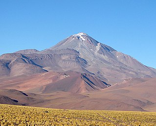
Nevado Ojos del Salado is a dormant complex volcano in the Andes on the Argentina–Chile border. It is the highest volcano on Earth and the highest peak in Chile. The upper reaches of Ojos del Salado consist of several overlapping lava domes, lava flows and volcanic craters, with sparse ice cover. The complex extends over an area of 70–160 square kilometres (27–62 sq mi) and its highest summit reaches an altitude of 6,893 metres (22,615 ft) above sea level. Numerous other volcanoes rise around Ojos del Salado.

Chacaltaya is a mountain in the Cordillera Real, one of the mountain ranges of the Cordillera Oriental, itself a range of the Bolivian Andes. Its elevation is 5,421 meters (17,785 ft). Chacaltaya's glacier — which was as old as 18,000 years — had an area of 0.22 km2 (0.085 sq mi) in 1940, which had been reduced to 0.01 km2 (0.0039 sq mi) in 2007 and was completely gone by 2009. Half of the meltdown, as measured by volume, took place before 1980. The final meltdown after 1980, due to missing precipitation and the warm phase of El Niño, resulted in the glacier's disappearance in 2009. The glacier was located about 30 kilometers (19 mi) from La Paz, near Huayna Potosí mountain.

Cerro Catedral is a mountain located 19 kilometres (12 mi) from San Carlos de Bariloche, and inside the Nahuel Huapí National Park, in Patagonia, Argentina.

Monte Pissis is an extinct volcano on the border of the La Rioja and Catamarca provinces in Argentina, 25 km (16 mi) to the east of the Chilean border and about 550 km (340 mi) north of Aconcagua. The mountain is the third-highest in the Western Hemisphere. Monte Pissis is named after Pedro José Amadeo Pissis, a French geologist who worked for the Chilean government. Due to its location in the Atacama Desert, the mountain has very dry conditions but features an extensive glacier, with crevasses, which is unique in the region. The peak is the highest summit on Earth without a permanent glacier.

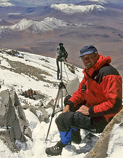
Johan Reinhard is an American anthropologist and archaeologist. Currently, he is a Research Professor at Future Generations University. formerly Explorer-in-Residence at the National Geographic Society. He is also a senior research fellow at The Mountain Institute, a visiting professor at Catholic University, Salta, Argentina, an honorary professor of Catholic University, Arequipa, Peru.

Since the mid-1990s, tourism in Chile has become one of the main sources of income for the country, especially in its most extreme areas. In 2005, this sector grew by 13.6%, generating more than US$500 million, equivalent to 1.33% of the national GDP.

Kílian Jornet is a Spanish professional long-distance trail runner and ski mountaineer. Jornet has won some of the most prestigious ultramarathons, including the Ultra-Trail du Mont-Blanc multiple times, Grand Raid, Western States and Hardrock.

Chearoco, Chiaraco or Chiaroco is a mountain in the Cordillera Real in the Andes of Bolivia. It has a height of about 6,127 m (20,102 ft). It is situated in the La Paz Department, Larecaja Province, Guanay Municipality, southeast of the peak of Aman Pata. Chearoco lies between Qalsata in the northwest and Chachakumani in the southeast.
Mercedes Noel "Tety" Sahores Rosauer is an Argentine ski mountaineer and mountain climber. She became the first Argentine woman to reach the summit of Mount Everest on May 19, 2009.
María Constanza Ceruti is an Argentine anthropologist and mountaineer, who has done more than 80 field surveys, most of them as part of National Geographic teams in Andean regions of Argentina, Chile, Bolivia, Ecuador and Peru. Her most important finding are the Children of Llullaillaco, considered the best preserved mummies in the world by the Guinness World Records. She is also the first woman worldwide to specialize in high-altitude archaeology, studying Inca ceremonial centers on the summits of Andean peaks above 6000 meters. She is a pioneer in the anthropological study of sacred mountains around the world, and in the emerging field of glacial archaeology.
Llullaillaco is a dormant stratovolcano on the border between Argentina and Chile. It lies in the Puna de Atacama, a region of tall volcanic peaks on a high plateau close to the Atacama Desert, one of the driest places in the world. Its maximum elevation is most commonly given as 6723 m, making it the second- or third-highest volcano in the world. Despite its height, it is not clear whether the volcano has any glaciers or merely patches of perennial snow and ice. Between 3700 m and 5000 m elevation there is a sparse plant cover, while at lower altitudes the climate is too dry for plants to grow. A species of mouse on Llullaillaco is the highest-living known vertebrate species.

Bola del Mundo or Alto de las Guarramillas is a mountain in the Sierra de Guadarrama, in the Sistema Central of the Iberian Peninsula. It is located in the Community of Madrid, near the border with the province of Segovia, in Spain. It has an altitude of 2257 meters with a prominence of 103 meters, and is the westernmost summit of the Cuerda Larga mountain range. Very close to the summit, on the east side, is the Ventisquero de la Condesa, an area with water emanations that constitutes the source of the Manzanares river, and where great thicknesses of snow accumulate in winter.