Contents

 Brooker Highway Brooker Highway
The Pacific Highway is a 780-kilometre-long (485 mi) national highway and major transport route along the central east coast of Australia, with the majority of it being part of Australia's Highway 1. The highway and its adjoining Pacific Motorway between Brisbane and Brunswick Heads and Pacific Motorway between Sydney and Newcastle links the state capitals of Sydney in New South Wales with Brisbane in Queensland, approximately paralleling the Tasman Sea of the South Pacific Ocean coast, via Gosford, Newcastle, Taree, Port Macquarie, Kempsey, Coffs Harbour, Grafton, and Ballina. Additionally, between Brunswick Heads and Port Macquarie, the road is also signed as the Pacific Motorway, but has not been legally gazetted as such.
U.S. Route 113 (US 113) is a U.S. Highway that is a spur of US 13 in the U.S. states of Maryland and Delaware. The route runs 74.75 miles (120.30 km) from US 13 in Pocomoke City, Maryland north to Delaware Route 1 (DE 1) in Milford, Delaware. In conjunction with DE 1, US 113 is one of two major north–south highways on the Delmarva Peninsula that connect Dover with Pocomoke City and the Eastern Shore of Virginia. The U.S. Highway is the primary north–south highway in Worcester County, Maryland, where it connects Pocomoke City with Snow Hill and Berlin. US 113 is one of three major north–south highways in Sussex County, Delaware, where it connects Selbyville, Millsboro, and Georgetown with Milford. While US 113 does not pass through Ocean City or the Delaware Beaches, the U.S. Highway intersects several highways that serve the Atlantic seaboard resorts, including US 50, Maryland Route 90 (MD 90), US 9, DE 404, DE 16, and DE 1. US 113 is a four-lane divided highway for its whole length.

State Highway 1 is the longest and most significant road in the New Zealand road network, running the length of both main islands. It appears on road maps as SH 1 and on road signs as a white number 1 on a red shield, but it has the official designations SH 1N in the North Island, SH 1S in the South Island.

U.S. Route 64 (US 64) is the longest numbered route in the U.S. state of North Carolina, running 604 miles (972 km) from the Tennessee state line to the Outer Banks. The route passes through the westernmost municipality in the state, Murphy, and one of the most easternmost municipalities, Manteo, making US 64 a symbolic representation of the phrase "from Murphy to Manteo" which is used to refer to the expanse of the state. The highway is a major east-west route through the central and eastern portion of the state.
Ring Road is a 4 lane controlled access highway in Regina, Saskatchewan, Canada. Ring Road is a partial ring road or beltway that forms a partial circle around Regina, bypasses the city on the north, east, and south sides, with Lewvan Drive and Pasqua Street N functioning as the de facto western leg. East of Pasqua Street, Ring Road continues west as 9th Avenue N, an arterial road. Ring Road has a speed limit of 100 km/h (60 mph) and consists of 13 interchanges.
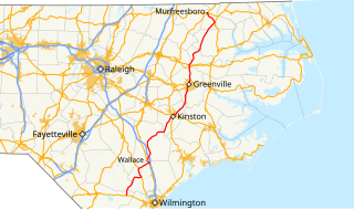
North Carolina Highway 11 (NC 11) is a primary state highway in the U.S. state of North Carolina. Traveling 193.2 miles (310.9 km) in a north–south alignment through Eastern North Carolina, it connects the towns and cities of Wallace, Kenansville, Kinston, Greenville and Murfreesboro.

State Route 11 (SR 11) is a 376-mile-long (605 km) state highway in the U.S. state of Georgia, traveling through portions of Echols, Lanier, Berrien, Irwin, Ben Hill, Wilcox, Pulaski, Houston, Peach, Bibb, Jones, Jasper, Newton, Walton, Barrow, Jackson, Hall, White, Lumpkin, and Union counties. It travels the entire length of the state from south to north, connecting the Florida state line with the North Carolina state line, roughly bisecting the state into two equal parts. It travels through Warner Robins, Macon, and Gainesville. It is the longest route in the state. The portion from the southeastern city limits of Monticello to the Jasper–Newton county line is included in the Monticello Crossroads Scenic Byway.
U.S. Route 70 (US 70) is a part of the United States Numbered Highway System that runs from Globe, Arizona, to the Crystal Coast of the US state of North Carolina. In North Carolina, it is a major 488-mile-long (785 km) east–west highway that runs from the Tennessee border to the Atlantic Ocean. From the Tennessee state line near Paint Rock to Asheville it follows the historic Dixie Highway, running concurrently with US 25. The highway connects several major cities including Asheville, High Point, Greensboro, Durham, Raleigh, Goldsboro, and New Bern. From Beaufort on east, US 70 shares part of the Outer Banks Scenic Byway, a National Scenic Byway, before ending in the community of Atlantic, located along Core Sound.
Several special routes of U.S. Route 1 exist, from Florida to Maine. In order from south to north, separated by type, these special routes are as follows.
A total of at least twenty-three special routes of U.S. Route 17 have existed.
The Regina Bypass is a four-lane twinned highway connector road in Regina, Saskatchewan. The 44.3-kilometre (27.5 mi) route connects Highway 1 with Highway 11, forming a partial ring road around the city of Regina.
National Highway 136, commonly referred to as NH 136, is a national highway of India. It comes under Ministry of Road Transport and Highways, Government of India. It is a secondary route of National Highway 36. NH-136 traverses the state of Tamil Nadu in India.
Alberta Provincial Highway No. 16X, commonly referred to as Highway 16X, is the designation of one former and three proposed routes off Highway 16 in Alberta, Canada. The former section was a 36 km (22 mi) east–west provincial highway in Edmonton Capital Region, that existed for approximately 20 years between the 1970s and 1997 and is now part of Highway 16. Right of way is set aside around Hinton, Edson, and Lloydminster that is presently designated as Highway 16X.
A total of at least seven special routes of U.S. Route 301 exist and at least eleven have been deleted.
Several special routes of U.S. Route 30 exist. In order from west to east they are as follows.
Several special routes of U.S. Route 19 exist. In order from south to north they are as follows.
At least 13 special routes of U.S. Route 11 and at least one of U.S. Route 11E have existed.

The Toowoomba Bypass, known as Toowoomba Second Range Crossing during planning and construction, is a 41.3 km (25.7 mi) grade separated, dual carriageway bypass and partial ring road constructed to the north and west of Toowoomba, Queensland. Construction commenced in April 2016. It opened to traffic on 8 September 2019.
The Russellville Bypass is a beltway around Russellville in Logan County in south central Kentucky. The 12.260-mile-long (19.731 km) highway comprises overlapping portions of U.S. Route 68 and Kentucky Route 80, US 79, and US 431. The north side of the circumferential highway was conceived in the 1980s to relieve traffic in downtown Russellville and as part of greater improvements along the US 68 corridor. The first two phases of the ring road, from US 79 on the west side to US 68 on the east side, were constructed in the 1990s. The state decided to complete the orbital road in the 2000s to resolve continuing traffic bottlenecks along US 431 and US 79 on the south side. The second two phases of the beltline were started in 2010 and completed in 2017. Construction of the Russellville Bypass led to a series of route changes over 20 years involving the city's U.S. Highways, special routes, and state-numbered highways.
Solitary Islands Way is a road in the Mid North Coast region of New South Wales, located north of the city of Coffs Harbour. It links the towns of Woolgoolga and Corindi Beach to the Pacific Highway. It consists of a mix of newly constructed roads, pre-existing Council-owned roads and former sections of the highway that were bypassed by new alignments in 2013 and 2017.