List of lakes in Faulkner County, Arkansas

Last updated
Map all coordinates using: OpenStreetMap  ·  Google Maps
Download coordinates as: KML  ·  GPX

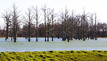
There are at least 38 named lakes and reservoirs in Faulkner County, Arkansas.

Lake A body of relatively still water, in a basin surrounded by land

A lake is an area filled with water, localized in a basin, that is surrounded by land, apart from any river or other outlet that serves to feed or drain the lake. Lakes lie on land and are not part of the ocean, and therefore are distinct from lagoons, and are also larger and deeper than ponds, though there are no official or scientific definitions. Lakes can be contrasted with rivers or streams, which are usually flowing. Most lakes are fed and drained by rivers and streams.

Reservoir A storage space for fluids

A reservoir is, most commonly, an enlarged natural or artificial lake, pond or impoundment created using a dam or lock to store water.

Faulkner County, Arkansas County in the United States

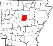
Faulkner County is a county located in the Central Arkansas region of the U.S. state of Arkansas. As of the 2010 census, the population was 113,237, making it the fifth most populous of Arkansas's seventy-five counties. The county seat and largest city is Conway. Faulkner County was created on April 12, 1873, one of nine counties formed during Reconstruction, and is named for Arkansas Militia Colonel Sandy Faulkner, a popular figure in the state at the time.

Contents

Lakes

Reservoirs

Lake Conway Lake Conway, Faulkner County, AR.jpg
Lake Conway
Lake Conway lake in Arkansas, United States of America

Lake Conway, a 6,700-acre (27 km2) lake in Arkansas, is the largest reservoir made by a game and fish commission in the United States. It is located just a few miles southeast of Conway, Arkansas.


See also

Notes

  1. "Boone Pond". Geographic Names Information System . United States Geological Survey.
  2. "Grassy Lake". Geographic Names Information System . United States Geological Survey.
  3. "Indian Head Lake". Geographic Names Information System . United States Geological Survey.
  4. "Bailey Lake". Geographic Names Information System . United States Geological Survey.
  5. "Beaver Fork Lake". Geographic Names Information System . United States Geological Survey.
  6. "Bivans Lake". Geographic Names Information System . United States Geological Survey.
  7. "Blacks Lake". Geographic Names Information System . United States Geological Survey.
  8. "Blacks Lake Number Two". Geographic Names Information System . United States Geological Survey.
  9. "Browns Lake". Geographic Names Information System . United States Geological Survey.
  10. "Brushlake Reservoir". Geographic Names Information System . United States Geological Survey.
  11. "Carter Lake". Geographic Names Information System . United States Geological Survey.
  12. "Davis Lake". Geographic Names Information System . United States Geological Survey.
  13. "Days Lake". Geographic Names Information System . United States Geological Survey.
  14. "Dears Pond". Geographic Names Information System . United States Geological Survey.
  15. "Deihl Lake". Geographic Names Information System . United States Geological Survey.
  16. "Gentry Lake". Geographic Names Information System . United States Geological Survey.
  17. "Jewell Lake". Geographic Names Information System . United States Geological Survey.
  18. "Lake Bennett". Geographic Names Information System . United States Geological Survey.
  19. "Lake Carol-Dan". Geographic Names Information System . United States Geological Survey.
  20. "Lake Conway". Geographic Names Information System . United States Geological Survey.
  21. "Lake Conway Nursery Pond". Geographic Names Information System . United States Geological Survey.
  22. "Lawrences Lake". Geographic Names Information System . United States Geological Survey.
  23. "Meers Lake". Geographic Names Information System . United States Geological Survey.
  24. "Montgomery Lake". Geographic Names Information System . United States Geological Survey.
  25. "Murray Lake". Geographic Names Information System . United States Geological Survey.
  26. "Nalholz Lake". Geographic Names Information System . United States Geological Survey.
  27. "Parks Lake". Geographic Names Information System . United States Geological Survey.
  28. "Pool Eight". Geographic Names Information System . United States Geological Survey.
  29. "Roberts Pond". Geographic Names Information System . United States Geological Survey.
  30. "Robins Lake". Geographic Names Information System . United States Geological Survey.
  31. "Stevens Lake". Geographic Names Information System . United States Geological Survey.
  32. "Stone Lake". Geographic Names Information System . United States Geological Survey.
  33. "Torian Lake". Geographic Names Information System . United States Geological Survey.
  34. "Tupelo Bayou Site One Reservoir". Geographic Names Information System . United States Geological Survey.
  35. "Tupelo Bayou Site Two Reservoir". Geographic Names Information System . United States Geological Survey.
  36. "Watson Lake". Geographic Names Information System . United States Geological Survey.
  37. "Williams Lake". Geographic Names Information System . United States Geological Survey.
  38. "Wisley Lake". Geographic Names Information System . United States Geological Survey.