List of lakes of Himachal Pradesh

Last updated

Reservoirs

Low Altitude Lakes

Mid Altitude Lakes

Sunrise at TaniJubbar Lake Sunrise at TaniJubbar Lake.jpg
Sunrise at TaniJubbar Lake
Khajjiar, Chamba Khajjiar.jpg
Khajjiar, Chamba

High Altitude Lakes

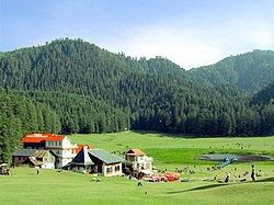
In the Shimla area lie the small rain water fed lakes of Tani Jubbar, Kunihar and Karwali that lies of the Choti Shali Peak. There are several natural ponds in the area-one lies below New Shimla and there is another between Mashobra and Carignano. [12]

Contents

Prashar Lake, Mandi, Himachal Pradesh

Related Research Articles

Himachal Pradesh State in northern India

Himachal Pradesh is a state in the northern part of India. Situated in the Western Himalayas, it is one of the thirteen mountain states and is characterized by an extreme landscape featuring several peaks and extensive river systems. Himachal Pradesh is the northernmost state of India and shares borders with the union territories of Jammu and Kashmir and Ladakh to the north, and the states of Punjab to the west, Haryana to the southwest, Uttarakhand to the southeast and a very narrow border with Uttar Pradesh to the south. The state also shares an international border to the east with the Tibet Autonomous Region in China. Himachal Pradesh is also known as Dev Bhoomi, meaning 'Land of God' and Veer Bhoomi which means 'Land of Braves'.

Dharamshala City in Himachal Pradesh, India

Dharamshala is the winter capital of Himachal Pradesh, India. It serves as administrative headquarters of the Kangra district after being relocated from Kangra, a city located 18 kilometres (11 mi) away from Dharamshala, in 1855.

Lahaul and Spiti district District of Himachal Pradesh in India

The Lahaul and Spiti district in the Indian state of Himachal Pradesh consists of the two formerly separate districts of Lahaul Tibetan Garzha and Spiti. The present administrative centre is Kyelang in Lahaul. Before the two districts were merged, Kardang was the capital of Lahaul, and Dhankar the capital of Spiti. The district was formed in 1960, and is the fourth least populous district in India . It is the least densely populated district of India, according to the Census of India 2011.

Mandi district District of Himachal Pradesh in India

Mandi district is one of the central districts of Himachal Pradesh state in northern India. The town of Mandi is the headquarters of the district. The town has mythological and historical significance and boasts of a unique temple architecture. It is referred to as Chhoti Kashi as there are many ancient temples in the city and on the banks of river Beas.

Dhauladhar

Dhauladhar is a mountain range which is part of a lesser Himalayan chain of mountains. It rises from the Shivalik hills, to the north of Kangra and Mandi. Dharamsala, the headquarters of Kangra district and the winter capital of Himachal Pradesh, lies on its southern spur in the Kangra Valley. Chamba lies to the North of this range.

Geography of Himachal Pradesh

The state of Himachal Pradesh is spread over an area 55,673 km2 (21,495 sq mi) and is bordered by Jammu and Kashmir and Ladakh on the north, Punjab on the southwest, Haryana on the south, Uttarakhand on the southeast, a small border with Uttar Pradesh in the south, and Tibet on the east. Entire Himachal Pradesh lies in the mountainous Himalaya region, rich in natural resources

Bara-lacha la

Bara-lacha la also known as Bara-lacha Pass, or Bārā Lācha La, is a high mountain pass in Zanskar range, connecting Lahaul district in Himachal Pradesh to Leh district in Ladakh. The Leh–Manali Highway traverses the pass.

The North Indian state of Himachal Pradesh is a state that has remained largely uninfluenced by Western culture. Himachal Pradesh is a multi-religion practising, multicultural and multilingual state. Some of the most commonly spoken languages are Hindi and the various Pahari languages. The Hindu communities residing in Himachal include the Brahmins, Rajputs, Kannets, Rathis and Kolis. There are also tribal population in the state which mainly comprise Gaddis, Kinnarms, Gujjars, Pangawals and Lahaulis.

Chandra Taal

Tso Chigma or Chandra Taal, or Chandra Tal is a lake in the Lahaul part of the Lahul and Spiti district of Himachal Pradesh (India). Chandra Taal is near the source of the Chandra River. Despite the rugged and inhospitable surroundings, it is in a protected niche with some flowers and wildlife in summer. It is a favourite spot for tourists and high-altitude trekkers. It is usually associated with Spiti, but geographically is a part of Lahaul. Kunzum La separates Lahaul and Spiti valleys.

Gobind Sagar

Gobind Sagar Lake is a reservoir situated in Una and Bilaspur districts of Himachal Pradesh. It is formed by the Bhakra Dam.

Ghadhasaru Lake or Gadasru Mahadev(Hindi: गदास्रू महादेव) is a high altitude lake which is located near Devikothi village of Teesa in the Churah tehsil of Chamba. It is about 3,470 m above the sea level at the base of a mountain Gadasaru Peak. This lake is held sacred and has a circumference of about 1 km.churah valley

Lama Dal or Laam Dal is a high altitude lake located in Piura Dhar, district Chamba about 3,960m above the sea level.

Spiti Valley River valley in Himachal Pradesh

Spiti Valley is a cold desert mountain valley located high in the Himalayas in the north-eastern part of the northern Indian state of Himachal Pradesh. The name "Spiti" means "The middle land", i.e. the land between Tibet and India.

The development of tribal areas in Himachal Pradesh is one of the major steps taken by the state government for its economic development. The border districts of Kinnaur, Lahaul, Spiti and the Pangi and Bharmour tehsils of Chamba districts are the major tribal areas of the state. They are located near the borders of Tibet and Indian States of Jammu and Kashmir. Other backward areas include Shillai in Sirmaur district, and deep cut-off valleys in the Kullu and upper stretches of Kangra districts. Due to poor accessibility, life in these areas had grown in isolation.

Suraj Tal Lake in Himachal Pradesh, India

Tso Kamtsi or Suraj Tal also called Surya Tal, is a 800 m (2,600 ft) long lake that lies just below the 4,890 m (16,040 ft) high Bara-lacha-la pass in Lahaul and Spiti valley of the Indian state of Himachal Pradesh. It is the third highest lake in India, and the 21st-highest in the world. Suraj Tal Lake is just below the source of the Bhaga River that joins the Chandra River downstream at Tandi to form the Chandrabhaga River in Himachal Pradesh. The Chandrabhaga River is renamed as the Chenab as it enters the Jammu region of the Jammu and Kashmir. The other major tributary of the Chandrabhaga, the Chandra originates and flows south-east of the Bara-lacha La.

Himachal Pradesh Cricket Association

Himachal Pradesh Cricket Association is the governing body of the Cricket activities in the Himachal Pradesh state of India and the Himachal Pradesh cricket team. It is affiliated to the Board of Control for Cricket in India. Anurag Thakur is removed from the post of President of Himachal Pradesh Cricket Association.

Western Himalayas Western half of the Himalayas mountain range

The Western Himalayas refers to the western half of the Himalayas, stretching from Badakhshan in northeastern Afghanistan/southern Tajikistan, Pakistan through northwestern India. It is also known as the Punjab Himalayas. All five tributaries of the Indus River in Punjab originate from the Western Himalayas.

Tourism in Himachal Pradesh Tourism in the Indian state of Himachal Pradesh

Tourism in Himachal Pradesh relates to tourism in the Indian state of Himachal Pradesh. This is popularly renowned for its Himalayan landscapes and popular hill-stations. Many outdoor activities such as rock climbing, mountain biking, paragliding, ice-skating, trekking, rafting, and heli-skiing are popular tourist attractions in Himachal Pradesh.

References

  1. "Prashar | District Mandi, Government of Himachal Pradesh | India".
  2. "Dehnasar Lake Trek".
  3. "Nako Lake". Times of India Travel.
  4. "Chandra Tal Lake Travel and Tourism Guide". India News, Breaking News, Entertainment News | India.com.
  5. Dey, Panchali. "Suraj Tal Lake and why it should be on your Manali to Leh trip itinerary". Times of India Travel.
  6. "Bhrigu Lake Trek - Events - INVINCIBLE | Surprise Yourself to Inspire Yourself". Invincible NGO.
  7. "Manimahesh Yatra | District Chamba, Government of Himachal Pradesh | India".
  8. "Gadasru Mahadev Lake | District Chamba, Government of Himachal Pradesh | India".
  9. "Mahakali Lake". www.himachaltouristguide.com.
  10. "Lama Dal". www.himachaltouristguide.com.
  11. "Kareri Lake | Trek & Route, Weather, Images, Best Time To Visit". www.holidify.com.
  12. "Data". Archived from the original on 24 March 2010. Retrieved 10 March 2020.