Name Location Date Listed Grid Ref. [note 1] Geo-coordinates Notes LB Number [note 2] Image Carronbridge Mill Office And Former Cartshed 55°15′37″N 3°46′59″W / 55.260414°N 3.782925°W / 55.260414; -3.782925 (Carronbridge Mill Office And Former Cartshed ) Category B 3867 Coshogle Farmhouse And Steading 55°19′33″N 3°47′47″W / 55.32596°N 3.796302°W / 55.32596; -3.796302 (Coshogle Farmhouse And Steading ) Category B 3880 Coshogle Cottage 55°19′43″N 3°47′33″W / 55.328613°N 3.792528°W / 55.328613; -3.792528 (Coshogle Cottage ) Category C(S) 3881 Crairiepark Farmhouse And Steading 55°19′07″N 3°48′57″W / 55.318633°N 3.815907°W / 55.318633; -3.815907 (Crairiepark Farmhouse And Steading ) Category B 3883 Drumlanrig Creel Bridge 55°17′08″N 3°48′12″W / 55.285647°N 3.803346°W / 55.285647; -3.803346 (Drumlanrig Creel Bridge ) Category B 3889 Durisdeer Village Hope Cottage 55°18′54″N 3°44′41″W / 55.314987°N 3.744795°W / 55.314987; -3.744795 (Durisdeer Village Hope Cottage ) Category C(S) 3859 Durisdeer Village Rose Cottage 55°18′55″N 3°44′40″W / 55.315216°N 3.744522°W / 55.315216; -3.744522 (Durisdeer Village Rose Cottage ) Category C(S) 3870 Enterkin Viaduct 55°19′10″N 3°48′05″W / 55.31954°N 3.801402°W / 55.31954; -3.801402 (Enterkin Viaduct ) Category B 3872 Crairiehill Farmhouse And Steading 55°18′47″N 3°48′23″W / 55.312949°N 3.806476°W / 55.312949; -3.806476 (Crairiehill Farmhouse And Steading ) Category B 3882 Drumlanrig Bridge Cottage 55°16′49″N 3°47′49″W / 55.280195°N 3.797037°W / 55.280195; -3.797037 (Drumlanrig Bridge Cottage ) Category B 3888 Upload another image
Drumlanrig Mains Offices, Sawmill And Workshops 55°16′54″N 3°48′31″W / 55.281795°N 3.80854°W / 55.281795; -3.80854 (Drumlanrig Mains Offices, Sawmill And Workshops ) Category B 3893 Sweetbit Farmhouse And Steading 55°18′22″N 3°48′15″W / 55.306046°N 3.804083°W / 55.306046; -3.804083 (Sweetbit Farmhouse And Steading ) Category B 3860 18-22 (Numbers Inclusive) Carronbridge Village 55°15′52″N 3°46′50″W / 55.264383°N 3.780694°W / 55.264383; -3.780694 (18-22 (Numbers Inclusive) Carronbridge Village ) Category B 3864 Carronbridge Village Miss Findlater (Formerly Smithy Cottage) Former Smithy And Smithy Cottage 55°15′53″N 3°46′49″W / 55.264657°N 3.780408°W / 55.264657; -3.780408 (Carronbridge Village Miss Findlater (Formerly Smithy Cottage) Former Smithy And Smithy Cottage ) Category C(S) 3865 Carronbridge Village Moss Side House And Gatepiers 55°16′01″N 3°46′56″W / 55.266996°N 3.782118°W / 55.266996; -3.782118 (Carronbridge Village Moss Side House And Gatepiers ) Category B 3868 Gateslack Farmhouse 55°18′12″N 3°44′52″W / 55.30326°N 3.747872°W / 55.30326; -3.747872 (Gateslack Farmhouse ) Category B 3873 Holestane Farmhouse, Steading, Dairy And Outbuildings 55°16′49″N 3°46′36″W / 55.280259°N 3.776697°W / 55.280259; -3.776697 (Holestane Farmhouse, Steading, Dairy And Outbuildings ) Category B 3876 Priestcrown Wood Railway Embankment 55°19′27″N 3°48′34″W / 55.324094°N 3.809458°W / 55.324094; -3.809458 (Priestcrown Wood Railway Embankment ) Category B 3879 Dalveen Farm Martyr's Monument 55°20′40″N 3°45′40″W / 55.344555°N 3.761061°W / 55.344555; -3.761061 (Dalveen Farm Martyr's Monument ) Category B 3885 Ballagan North Range Of Steading (Former Stable, Cartshed And Barn) 55°17′33″N 3°50′21″W / 55.29249°N 3.839219°W / 55.29249; -3.839219 (Ballagan North Range Of Steading (Former Stable, Cartshed And Barn) ) Category B 3896 Drumlanrig Summer House North Of Duchess Well 55°16′23″N 3°48′48″W / 55.273161°N 3.813201°W / 55.273161; -3.813201 (Drumlanrig Summer House North Of Duchess Well ) Category B 3854 Durisdeer Village Durisdeer Parish Church, Queensberry Mausoleum, Former School/Vestry And Churchyard 55°18′56″N 3°44′39″W / 55.315536°N 3.744157°W / 55.315536; -3.744157 (Durisdeer Village Durisdeer Parish Church, Queensberry Mausoleum, Former School/Vestry And Churchyard ) Category A 3856 Durisdeer Village Castlehill Cottage 55°18′57″N 3°45′10″W / 55.315772°N 3.752725°W / 55.315772; -3.752725 (Durisdeer Village Castlehill Cottage ) Category C(S) 3857 Carronbridge Village Carronfoot House 55°15′47″N 3°47′06″W / 55.262972°N 3.784975°W / 55.262972; -3.784975 (Carronbridge Village Carronfoot House ) Category B 3866 Kirkbride Churchyard 55°19′54″N 3°48′25″W / 55.331583°N 3.80682°W / 55.331583; -3.80682 (Kirkbride Churchyard ) Category B 3877 Dalveen Farm House Steading And Barn 55°20′37″N 3°45′39″W / 55.343641°N 3.760863°W / 55.343641; -3.760863 (Dalveen Farm House Steading And Barn ) Category B 3884 Drumlanrig Bridge (Drumlanrig Castle East Approach Over River Nith 55°16′47″N 3°47′49″W / 55.279692°N 3.797014°W / 55.279692; -3.797014 (Drumlanrig Bridge (Drumlanrig Castle East Approach Over River Nith ) Category B 3887 Upload another image
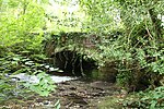
Drumlanrig Laundry Cottages 55°16′36″N 3°48′38″W / 55.276749°N 3.810641°W / 55.276749; -3.810641 (Drumlanrig Laundry Cottages ) Category B 3892 Alton Farmhouse And Steading 55°17′49″N 3°48′22″W / 55.296967°N 3.806049°W / 55.296967; -3.806049 (Alton Farmhouse And Steading ) Category B 3894 Drumlanrig St Geoffrey's Bridge 55°16′17″N 3°49′01″W / 55.271399°N 3.816914°W / 55.271399; -3.816914 (Drumlanrig St Geoffrey's Bridge ) Category C(S) 3853 Upload another image
Carronbank Cottage And Outbuildings 55°17′33″N 3°45′42″W / 55.292493°N 3.761668°W / 55.292493; -3.761668 (Carronbank Cottage And Outbuildings ) Category B 3862 Glenarlie Bridge 55°19′51″N 3°50′15″W / 55.330928°N 3.837532°W / 55.330928; -3.837532 (Glenarlie Bridge ) Category B 3874 Drumlanrig Gardener's Cottage (At Flower Garden) 55°16′23″N 3°48′23″W / 55.27312°N 3.806273°W / 55.27312; -3.806273 (Drumlanrig Gardener's Cottage (At Flower Garden) ) Category C(S) 3890 Drumlanrig Glass House In Flower Garden 55°16′23″N 3°48′23″W / 55.272967°N 3.806282°W / 55.272967; -3.806282 (Drumlanrig Glass House In Flower Garden ) Category B 3891 Upload another image
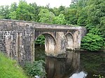
Ardoch Farmhouse And Steading 55°19′45″N 3°49′54″W / 55.32919°N 3.831776°W / 55.32919; -3.831776 (Ardoch Farmhouse And Steading ) Category B 3895 Drumlanrig Cottages At Drumlanrig Mains 55°16′52″N 3°48′34″W / 55.281182°N 3.809316°W / 55.281182; -3.809316 (Drumlanrig Cottages At Drumlanrig Mains ) Category C(S) 3852 Durisdeer Village Glenview Mr Henson 55°18′54″N 3°44′38″W / 55.314963°N 3.743959°W / 55.314963; -3.743959 (Durisdeer Village Glenview Mr Henson ) Category B 3858 Carron Water And A702 Railway Viaduct 55°17′29″N 3°45′52″W / 55.291501°N 3.764396°W / 55.291501; -3.764396 (Carron Water And A702 Railway Viaduct ) Category B 3861 Carronbridge Village Carron Bridge (A76 Over Carron Water) 55°15′51″N 3°46′49″W / 55.264246°N 3.780232°W / 55.264246; -3.780232 (Carronbridge Village Carron Bridge (A76 Over Carron Water) ) Category B 3863 Drumlanrig Summerhouse To South West Of Mansion 55°16′23″N 3°48′48″W / 55.273161°N 3.813201°W / 55.273161; -3.813201 (Drumlanrig Summerhouse To South West Of Mansion ) Category B 3855 Upload another image
Durisdeer Mill Village Old Foot Bridge Over Carron Water 55°19′07″N 3°45′42″W / 55.318744°N 3.761697°W / 55.318744; -3.761697 (Durisdeer Mill Village Old Foot Bridge Over Carron Water ) Category B 3871 Hapland Farmhouse And Steading 55°18′56″N 3°47′30″W / 55.315648°N 3.791612°W / 55.315648; -3.791612 (Hapland Farmhouse And Steading ) Category B 3875 Chapel Farmhouse And Steading 55°19′49″N 3°45′58″W / 55.330356°N 3.76598°W / 55.330356; -3.76598 (Chapel Farmhouse And Steading ) Category B 3869 Drumlanrig Castle , Outbuildings and Pavilion Blocks Piers, Balustrades and Quadrant Walls and Garden Urns 55°16′25″N 3°48′31″W / 55.273651°N 3.808705°W / 55.273651; -3.808705 (Drumlanrig Castle, Outbuildings and Pavilion Blocks Piers, Balustrades and Quadrant Walls and Garden Urns ) Category A 3886 Upload another image See more images