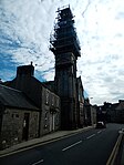
Name Location Date Listed Grid Ref. [note 1] Geo-coordinates Notes LB Number [note 2] Image Townhead, Eskvale 55°09′09″N 3°00′02″W / 55.152424°N 3.000511°W / 55.152424; -3.000511 (Townhead, Eskvale ) Category B 37143 Upload Photo Buccleuch Square, Pump 55°09′11″N 3°00′14″W / 55.153096°N 3.003996°W / 55.153096; -3.003996 (Buccleuch Square, Pump ) Category B 37108 Upload Photo Charles Street Old, Langholm Parish Church Hall 55°09′01″N 3°00′06″W / 55.150338°N 3.001698°W / 55.150338; -3.001698 (Charles Street Old, Langholm Parish Church Hall ) Category C(S) 37109 Upload another image See more images
26, 28, 30 Drove Road 55°09′00″N 2°59′50″W / 55.149971°N 2.997201°W / 55.149971; -2.997201 (26, 28, 30 Drove Road ) Category B 37113 Upload Photo 1-63 (Inclusive Nos) Eskdaill Street 55°09′01″N 3°00′30″W / 55.150409°N 3.008416°W / 55.150409; -3.008416 (1-63 (Inclusive Nos) Eskdaill Street ) Category B 37114 Upload Photo 97 High Street 55°08′59″N 2°59′50″W / 55.149819°N 2.997088°W / 55.149819; -2.997088 (97 High Street ) Category C(S) 37126 Upload Photo 12, 14 High Street 55°09′07″N 3°00′02″W / 55.151957°N 3.000436°W / 55.151957; -3.000436 (12, 14 High Street ) Category C(S) 37130 Upload Photo Langholm Lodge (Both Houses) 55°09′29″N 3°00′42″W / 55.158182°N 3.01172°W / 55.158182; -3.01172 (Langholm Lodge (Both Houses) ) Category B 9733 Upload Photo Malcolm Monument On Whita Hill 55°09′09″N 2°58′32″W / 55.1526°N 2.97547°W / 55.1526; -2.97547 (Malcolm Monument On Whita Hill ) Category B 9762 Upload Photo 9 High Street, Erskine Parish Church (North U.P. Church ) 55°09′08″N 3°00′00″W / 55.152356°N 2.999991°W / 55.152356; -2.999991 (9 High Street, Erskine Parish Church (North U.P. Church) ) Category B 37117 Upload another image See more images
15, 17 (Odd Nos) High Street, Buck Hotel Including Barn At Rear 55°09′07″N 3°00′00″W / 55.152032°N 3.000093°W / 55.152032; -3.000093 (15, 17 (Odd Nos) High Street, Buck Hotel Including Barn At Rear ) Category C(S) 37119 Upload Photo High Street, Statue Of Sir Pulteney Malcolm (In Library Garden) 55°09′02″N 2°59′53″W / 55.150431°N 2.998138°W / 55.150431; -2.998138 (High Street, Statue Of Sir Pulteney Malcolm (In Library Garden) ) Category C(S) 37124 Upload Photo High Street, Ashley Bank Hotel, Lodge And Retaining Walls 55°08′58″N 2°59′47″W / 55.149412°N 2.996371°W / 55.149412; -2.996371 (High Street, Ashley Bank Hotel, Lodge And Retaining Walls ) Category B 37128 Upload Photo Broomholm House And Gatepiers 55°07′30″N 2°59′08″W / 55.125084°N 2.985431°W / 55.125084; -2.985431 (Broomholm House And Gatepiers ) Category B 9752 Upload Photo Broomholm House, Sundial 55°07′32″N 2°59′05″W / 55.125674°N 2.984724°W / 55.125674; -2.984724 (Broomholm House, Sundial ) Category B 9753 Upload Photo Thomas Telford Road, Langholm Academy (Block On South Side Of Road) 55°09′12″N 3°00′23″W / 55.153319°N 3.006418°W / 55.153319; -3.006418 (Thomas Telford Road, Langholm Academy (Block On South Side Of Road) ) Category B 37141 Upload Photo Townhead, Clinthead 55°09′10″N 3°00′02″W / 55.15273°N 3.000456°W / 55.15273; -3.000456 (Townhead, Clinthead ) Category B 37144 Upload Photo 11 High Street, Townhead House 55°09′08″N 3°00′01″W / 55.15221°N 3.00027°W / 55.15221; -3.00027 (11 High Street, Townhead House ) Category B 37118 Upload Photo High Street, Town House 55°09′02″N 2°59′54″W / 55.150573°N 2.998299°W / 55.150573; -2.998299 (High Street, Town House ) Category B 37122 Upload another image See more images
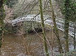
30 High Street/2 John Street, Bank Of Scotland Building 55°09′06″N 3°00′00″W / 55.151637°N 3.000052°W / 55.151637; -3.000052 (30 High Street/2 John Street, Bank Of Scotland Building ) Category B 37131 Upload Photo 74-80 (Even Nos) High Street 55°09′02″N 2°59′55″W / 55.150499°N 2.998595°W / 55.150499; -2.998595 (74-80 (Even Nos) High Street ) Category C(S) 37134 Upload Photo High Street, Tollbar Cottage South 55°08′55″N 2°59′41″W / 55.148616°N 2.994782°W / 55.148616; -2.994782 (High Street, Tollbar Cottage South ) Category B 37135 Upload Photo Ewesbank House And Adjoining Cottage, Workshops/Stores 55°09′23″N 3°00′03″W / 55.15642°N 3.000893°W / 55.15642; -3.000893 (Ewesbank House And Adjoining Cottage, Workshops/Stores ) Category B 9757 Upload Photo Staplegordon Old Churchyard 55°10′53″N 3°01′08″W / 55.181317°N 3.018776°W / 55.181317; -3.018776 (Staplegordon Old Churchyard ) Category B 9719 Upload Photo Townhead, Tollbar Cottage North 55°09′12″N 3°00′01″W / 55.15337°N 3.000174°W / 55.15337; -3.000174 (Townhead, Tollbar Cottage North ) Category B 37145 Upload Photo Suspension Bridge (Boatford Bridge) 55°09′03″N 3°00′08″W / 55.150847°N 3.002119°W / 55.150847; -3.002119 (Suspension Bridge (Boatford Bridge) ) Category B 37139 Upload another image See more images
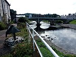
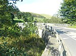
Thomas Telford Road, The Holm 55°09′11″N 3°00′16″W / 55.153038°N 3.004544°W / 55.153038; -3.004544 (Thomas Telford Road, The Holm ) Category C(S) 37140 Upload Photo Townhead, Bridge (B709 Over River Esk) 55°09′09″N 3°00′04″W / 55.152402°N 3.001059°W / 55.152402; -3.001059 (Townhead, Bridge (B709 Over River Esk) ) Category B 37146 Upload another image See more images
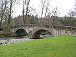
High Street, Crown Hotel 55°09′06″N 2°59′58″W / 55.151589°N 2.99936°W / 55.151589; -2.99936 (High Street, Crown Hotel ) Category B 37121 Upload Photo High Street, Telford Doorcase Or Gateway (In Library Garden) 55°09′02″N 2°59′53″W / 55.150467°N 2.998139°W / 55.150467; -2.998139 (High Street, Telford Doorcase Or Gateway (In Library Garden) ) Category B 37125 Upload Photo Langholm Old Churchyard 55°09′07″N 2°59′52″W / 55.151854°N 2.997735°W / 55.151854; -2.997735 (Langholm Old Churchyard ) Category C(S) 37136 Upload Photo Langholm Parish Church, Driveway Bridge, Gates And Gatepiers 55°09′03″N 3°00′10″W / 55.150814°N 3.00284°W / 55.150814; -3.00284 (Langholm Parish Church, Driveway Bridge, Gates And Gatepiers ) Category B 37138 Upload Photo Langholm Lodge, Duchess Bridge (Over River Esk) 55°09′26″N 3°00′44″W / 55.157269°N 3.01234°W / 55.157269; -3.01234 (Langholm Lodge, Duchess Bridge (Over River Esk) ) Category A 9734 Upload another image See more images
Longwood Cottage And Outbuilding With Glass House 55°08′15″N 2°59′14″W / 55.137507°N 2.987212°W / 55.137507; -2.987212 (Longwood Cottage And Outbuilding With Glass House ) Category B 9761 Upload Photo Milnholm Farmhouse And Steading 55°10′32″N 3°00′50″W / 55.175668°N 3.014016°W / 55.175668; -3.014016 (Milnholm Farmhouse And Steading ) Category A 9763 Upload Photo Thomas Telford Road, Schoolhouse 55°09′12″N 3°00′16″W / 55.153236°N 3.004439°W / 55.153236; -3.004439 (Thomas Telford Road, Schoolhouse ) Category B 37142 Upload Photo David Street, Thomas Hope Hospital, Hospital Lodge, Mortuary And Enclosure Walls, Gates And Railings 55°09′03″N 2°59′57″W / 55.150808°N 2.999215°W / 55.150808; -2.999215 (David Street, Thomas Hope Hospital, Hospital Lodge, Mortuary And Enclosure Walls, Gates And Railings ) Category B 37110 Upload Photo Ewes Bridge (Over Ewes Water) 55°09′20″N 3°00′04″W / 55.155492°N 3.001168°W / 55.155492; -3.001168 (Ewes Bridge (Over Ewes Water) ) Category B 37115 Upload another image See more images
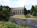
56 High Street And The Edinburgh Woollen Mill Shop, Market Place 55°09′04″N 2°59′57″W / 55.150998°N 2.999126°W / 55.150998; -2.999126 (56 High Street And The Edinburgh Woollen Mill Shop, Market Place ) Category C(S) 37132 Upload Photo Langholm Parish Church 55°09′01″N 3°00′12″W / 55.150396°N 3.003426°W / 55.150396; -3.003426 (Langholm Parish Church ) Category A 37137 Upload another image See more images
Broomholm House, Steading And Former Stables 55°07′34″N 2°59′05″W / 55.12606°N 2.984796°W / 55.12606; -2.984796 (Broomholm House, Steading And Former Stables ) Category B 9754 Upload Photo Highmill Bridge (A7 Over Ewes Water) 55°09′46″N 2°59′32″W / 55.162781°N 2.992263°W / 55.162781; -2.992263 (Highmill Bridge (A7 Over Ewes Water) ) Category B 9758 Upload another image See more images
Langholm Lodge, Episcopal Church 55°09′24″N 3°00′12″W / 55.156553°N 3.003266°W / 55.156553; -3.003266 (Langholm Lodge, Episcopal Church ) Category B 9760 Upload Photo Skipper's Bridge (A7 Over River Esk) 55°08′27″N 2°59′20″W / 55.140936°N 2.988818°W / 55.140936; -2.988818 (Skipper's Bridge (A7 Over River Esk) ) Category A 9764 Upload another image See more images
Springhill (Former Wauchope Manse) 55°08′52″N 3°00′44″W / 55.147842°N 3.012321°W / 55.147842; -3.012321 (Springhill (Former Wauchope Manse) ) Category C(S) 9765 Upload Photo 8 Buccleuch Square, Hamnavoe 55°09′11″N 3°00′16″W / 55.152957°N 3.004573°W / 55.152957; -3.004573 (8 Buccleuch Square, Hamnavoe ) Category C(S) 37107 Upload Photo House To South Of 12 Drove Road, Fronting Un-Named Close 55°09′06″N 2°59′55″W / 55.15155°N 2.998574°W / 55.15155; -2.998574 (House To South Of 12 Drove Road, Fronting Un-Named Close ) Category C(S) 37112 Upload Photo Glenesk Road, Waverley Mills 55°08′50″N 2°59′50″W / 55.147346°N 2.997293°W / 55.147346; -2.997293 (Glenesk Road, Waverley Mills ) Category B 37116 Upload Photo Cleuchfoot 55°08′06″N 3°04′35″W / 55.134991°N 3.076308°W / 55.134991; -3.076308 (Cleuchfoot ) Category B 9755 Upload Photo Wauchope Churchyard 55°08′49″N 3°00′47″W / 55.146865°N 3.013159°W / 55.146865; -3.013159 (Wauchope Churchyard ) Category B 9720 Upload Photo Buccleuch Square, Police Station Building 55°09′10″N 3°00′16″W / 55.152859°N 3.004492°W / 55.152859; -3.004492 (Buccleuch Square, Police Station Building ) Category B 37106 Upload Photo Drove Road, House Opposite Number 26 55°09′00″N 2°59′49″W / 55.149964°N 2.996966°W / 55.149964; -2.996966 (Drove Road, House Opposite Number 26 ) Category C(S) 37111 Upload Photo High Street, Royal Bank Of Scotland Building 55°09′06″N 2°59′58″W / 55.151668°N 2.999535°W / 55.151668; -2.999535 (High Street, Royal Bank Of Scotland Building ) Category C(S) 37120 Upload Photo High Street, Library 55°09′02″N 2°59′54″W / 55.150564°N 2.998283°W / 55.150564; -2.998283 (High Street, Library ) Category B 37123 Upload Photo High Street, Buccleuch House 55°08′59″N 2°59′49″W / 55.149713°N 2.996928°W / 55.149713; -2.996928 (High Street, Buccleuch House ) Category B 37127 Upload Photo 10 High Street, Bridge House 55°09′08″N 3°00′02″W / 55.1521°N 3.000597°W / 55.1521; -3.000597 (10 High Street, Bridge House ) Category C(S) 37129 Upload Photo High Street, Eskdale Hotel 55°09′02″N 2°59′56″W / 55.15064°N 2.998928°W / 55.15064; -2.998928 (High Street, Eskdale Hotel ) Category B 37133 Upload Photo