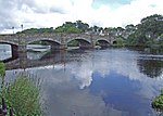
Name Location Date Listed Grid Ref. [note 1] Geo-coordinates Notes LB Number [note 2] Image 19-21 Albert Street 54°57′24″N 4°28′58″W / 54.956543°N 4.482778°W / 54.956543; -4.482778 (19-21 Albert Street ) Category C(S) 38654 Corvisel Road, Lynwood And Railings 54°57′17″N 4°29′11″W / 54.954715°N 4.486445°W / 54.954715; -4.486445 (Corvisel Road, Lynwood And Railings ) Category C(S) 38666 Cree Bridge 54°57′36″N 4°28′57″W / 54.960128°N 4.482452°W / 54.960128; -4.482452 (Cree Bridge ) Category A 38667 Upload another image
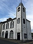
King Street Corsbie West 54°57′55″N 4°29′19″W / 54.965179°N 4.488607°W / 54.965179; -4.488607 (King Street Corsbie West ) Category B 38671 Penkiln Suspension Footbridge 54°58′01″N 4°29′08″W / 54.967051°N 4.485457°W / 54.967051; -4.485457 (Penkiln Suspension Footbridge ) Category B 38675 101 And 102 Queen Street, The Crown Hotel 54°57′12″N 4°28′55″W / 54.953209°N 4.481838°W / 54.953209; -4.481838 (101 And 102 Queen Street, The Crown Hotel ) Category C(S) 38682 36-38 (Even Nos) Victoria Street 54°57′48″N 4°29′08″W / 54.963247°N 4.485519°W / 54.963247; -4.485519 (36-38 (Even Nos) Victoria Street ) Category C(S) 38695 11 Dashwood Square, Star Inn 54°57′22″N 4°29′00″W / 54.956083°N 4.48328°W / 54.956083; -4.48328 (11 Dashwood Square, Star Inn ) Category C(S) 38653 Church Street, Penninghame Graveyard With Mausoleum 54°57′25″N 4°29′07″W / 54.956989°N 4.485179°W / 54.956989; -4.485179 (Church Street, Penninghame Graveyard With Mausoleum ) Category B 38662 2, 4, 6 Princes Street And 1 Dashwood Square 54°57′21″N 4°29′04″W / 54.955837°N 4.484359°W / 54.955837; -4.484359 (2, 4, 6 Princes Street And 1 Dashwood Square ) Category B 38676 Princes Street, Glenkiel House Former Penninghame Manse With Coach House, Gates, Gatepiers And Railings 54°57′19″N 4°29′13″W / 54.955252°N 4.487009°W / 54.955252; -4.487009 (Princes Street, Glenkiel House Former Penninghame Manse With Coach House, Gates, Gatepiers And Railings ) Category B 38677 Princes Street, Former Uf Manse 54°57′19″N 4°29′08″W / 54.955284°N 4.485434°W / 54.955284; -4.485434 (Princes Street, Former Uf Manse ) Category C(S) 38679 1 Victoria Street 54°57′27″N 4°28′57″W / 54.95753°N 4.482432°W / 54.95753; -4.482432 (1 Victoria Street ) Category B 38684 77-79 (Odd Nos) Victoria Street, Old Town Hall 54°57′34″N 4°28′59″W / 54.959334°N 4.483028°W / 54.959334; -4.483028 (77-79 (Odd Nos) Victoria Street, Old Town Hall ) Category B 38686 Upload another image
4-10 (Even Nos) Victoria Street 54°57′28″N 4°28′58″W / 54.957756°N 4.482837°W / 54.957756; -4.482837 (4-10 (Even Nos) Victoria Street ) Category C(S) 38689 76-78 (Even Nos) Victoria Street And Boundary Walls 54°57′35″N 4°29′01″W / 54.959718°N 4.483583°W / 54.959718; -4.483583 (76-78 (Even Nos) Victoria Street And Boundary Walls ) Category B 38699 Albert Street, Bank Of Scotland 54°57′25″N 4°28′57″W / 54.956963°N 4.482476°W / 54.956963; -4.482476 (Albert Street, Bank Of Scotland ) Category B 38655 37 And 39 Albert Street, Albert House 54°57′26″N 4°28′57″W / 54.957216°N 4.482413°W / 54.957216; -4.482413 (37 And 39 Albert Street, Albert House ) Category C(S) 38656 Corvisel House, Walled Garden Boundary Walls And Gatepiers 54°56′58″N 4°28′40″W / 54.94957°N 4.477834°W / 54.94957; -4.477834 (Corvisel House, Walled Garden Boundary Walls And Gatepiers ) Category B 38664 12 And 12A Dashwood Square 54°57′21″N 4°28′59″W / 54.95597°N 4.483133°W / 54.95597; -4.483133 (12 And 12A Dashwood Square ) Category C(S) 38668 Victoria Street, Clydesdale Bank 54°57′34″N 4°28′59″W / 54.959531°N 4.48304°W / 54.959531; -4.48304 (Victoria Street, Clydesdale Bank ) Category C(S) 38687 2 Victoria Street, The Central Bar 54°57′27″N 4°28′58″W / 54.957559°N 4.482778°W / 54.957559; -4.482778 (2 Victoria Street, The Central Bar ) Category B 38688 Victoria Street, The Galloway Arms Hotel 54°57′33″N 4°29′00″W / 54.95929°N 4.483385°W / 54.95929; -4.483385 (Victoria Street, The Galloway Arms Hotel ) Category B 38697 Windsor Road, Roman Catholic Presbytery And Churchyward With Boundary Walls, Gatepiers, Gates And Railings 54°57′41″N 4°29′12″W / 54.961509°N 4.486568°W / 54.961509; -4.486568 (Windsor Road, Roman Catholic Presbytery And Churchyward With Boundary Walls, Gatepiers, Gates And Railings ) Category B 38702 4 And 5 Church Street 54°57′25″N 4°29′03″W / 54.956876°N 4.484079°W / 54.956876; -4.484079 (4 And 5 Church Street ) Category C(S) 38659 Princes Street, Former St Johns Church Hall 54°57′20″N 4°29′08″W / 54.955633°N 4.485518°W / 54.955633; -4.485518 (Princes Street, Former St Johns Church Hall ) Category B 38678 30 And 32 Victoria Street 54°57′30″N 4°28′59″W / 54.958471°N 4.483037°W / 54.958471; -4.483037 (30 And 32 Victoria Street ) Category B 38694 York Road, Former Douglas-Ewart High School, Hill View Apartments 54°57′39″N 4°29′12″W / 54.960815°N 4.486619°W / 54.960815; -4.486619 (York Road, Former Douglas-Ewart High School, Hill View Apartments ) Category B 38703 41-43 (Odd Nos) Albert Street 54°57′26″N 4°28′57″W / 54.957351°N 4.482375°W / 54.957351; -4.482375 (41-43 (Odd Nos) Albert Street ) Category C(S) 38657 Dashwood Square, The Mcmillan Hall , Railings And Gates 54°57′21″N 4°29′02″W / 54.955714°N 4.483773°W / 54.955714; -4.483773 (Dashwood Square, The Mcmillan Hall, Railings And Gates ) Category B 38669 Upload another image
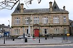
King Street, Douglas House, Former Douglas School 54°58′00″N 4°29′15″W / 54.966741°N 4.487422°W / 54.966741; -4.487422 (King Street, Douglas House, Former Douglas School ) Category A 38672 38 King Street, The Beeches 54°57′49″N 4°29′09″W / 54.963475°N 4.485799°W / 54.963475; -4.485799 (38 King Street, The Beeches ) Category C(S) 38673 Queen Street, The Mart, Sale Hall, Office And Railings 54°57′11″N 4°28′58″W / 54.953065°N 4.482735°W / 54.953065; -4.482735 (Queen Street, The Mart, Sale Hall, Office And Railings ) Category B 38683 69-73 (Odd Nos) Victoria Street 54°57′33″N 4°28′58″W / 54.959078°N 4.482778°W / 54.959078; -4.482778 (69-73 (Odd Nos) Victoria Street ) Category B 38685 28 Victoria Street 54°57′30″N 4°28′59″W / 54.958336°N 4.483013°W / 54.958336; -4.483013 (28 Victoria Street ) Category C(S) 38693 York Road, Former Uf Church, Now Newton Stewart Museum With Boundary Walls Gatepiers, And Railings 54°57′35″N 4°29′10″W / 54.959665°N 4.486188°W / 54.959665; -4.486188 (York Road, Former Uf Church, Now Newton Stewart Museum With Boundary Walls Gatepiers, And Railings ) Category B 38704 47-49A (Odd Nos) Albert Street 54°57′27″N 4°28′57″W / 54.957396°N 4.482377°W / 54.957396; -4.482377 (47-49A (Odd Nos) Albert Street ) Category C(S) 38658 Church Street, Penninghame Parish Church, St John's (Church_Of Scotland), Boundary Walls And Railings 54°57′28″N 4°29′07″W / 54.957904°N 4.485267°W / 54.957904; -4.485267 (Church Street, Penninghame Parish Church, St John's (Church_Of Scotland), Boundary Walls And Railings ) Category A 38663 Upload another image
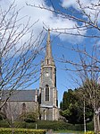
2, Corvisel Road, Prospect House 54°57′18″N 4°29′10″W / 54.955091°N 4.486093°W / 54.955091; -4.486093 (2, Corvisel Road, Prospect House ) Category C(S) 38665 23 King Street, Former Brewery House 54°57′47″N 4°29′06″W / 54.963105°N 4.48501°W / 54.963105; -4.48501 (23 King Street, Former Brewery House ) Category B 38670 12 Victoria Street 54°57′28″N 4°28′58″W / 54.957756°N 4.482837°W / 54.957756; -4.482837 (12 Victoria Street ) Category C(S) 38690 40-44 (Even Nos) Victoria Street, The Royal Bank Of Scotland 54°57′32″N 4°29′00″W / 54.958826°N 4.483215°W / 54.958826; -4.483215 (40-44 (Even Nos) Victoria Street, The Royal Bank Of Scotland ) Category B 38696 Victoria Street, Monument To 9Th Earl Of Galloway 54°57′35″N 4°28′59″W / 54.959747°N 4.483038°W / 54.959747; -4.483038 (Victoria Street, Monument To 9Th Earl Of Galloway ) Category B 38700 Windsor Road, Roman Catholic Church Of Our Lady And St Ninian And Churchyard 54°57′42″N 4°29′11″W / 54.96154°N 4.486351°W / 54.96154; -4.486351 (Windsor Road, Roman Catholic Church Of Our Lady And St Ninian And Churchyard ) Category B 38701 7 Church Street 54°57′25″N 4°29′03″W / 54.95694°N 4.484036°W / 54.95694; -4.484036 (7 Church Street ) Category C(S) 38660 2 Queen Street, Dashwood House 54°57′21″N 4°29′00″W / 54.955811°N 4.483404°W / 54.955811; -4.483404 (2 Queen Street, Dashwood House ) Category B 38680 Queen Street, Black Horse Hotel With Coach House 54°57′15″N 4°28′57″W / 54.954178°N 4.482382°W / 54.954178; -4.482382 (Queen Street, Black Horse Hotel With Coach House ) Category C(S) 38681 24-26A (Even Nos) Victoria Street 54°57′30″N 4°28′59″W / 54.958265°N 4.482962°W / 54.958265; -4.482962 (24-26A (Even Nos) Victoria Street ) Category C(S) 38692 32 King Street 54°57′47″N 4°29′07″W / 54.963045°N 4.485272°W / 54.963045; -4.485272 (32 King Street ) Category C(S) 49412 13 Church Street 54°57′27″N 4°29′04″W / 54.957599°N 4.484358°W / 54.957599; -4.484358 (13 Church Street ) Category C(S) 38661 King Street, Little Corsbie 54°57′54″N 4°29′13″W / 54.964873°N 4.486901°W / 54.964873; -4.486901 (King Street, Little Corsbie ) Category B 38674 20-22 (Even Nos) Victoria Street 54°57′29″N 4°28′59″W / 54.958094°N 4.482967°W / 54.958094; -4.482967 (20-22 (Even Nos) Victoria Street ) Category C(S) 38691 70-74 (Even Nos) Victoria Street 54°57′34″N 4°29′01″W / 54.959575°N 4.483558°W / 54.959575; -4.483558 (70-74 (Even Nos) Victoria Street ) Category C(S) 38698