Related Research Articles

Armadale is a suburb of Perth within the City of Armadale, located on the south-eastern edge of the Perth metropolitan region. The major junction of the South Western and Albany Highways, which connect Perth with the South West and Great Southern regions of Western Australia respectively, is located within the suburb. It is also the terminus of the Armadale railway line, one of five major railway lines to service Perth.
The City of Gosnells is a local government area in the southeastern suburbs of the Western Australian capital city of Perth, located northwest of Armadale and about 20 kilometres (12 mi) southeast of Perth's central business district. The City covers an area of 128 square kilometres (49.42 sq mi), a portion of which is state forest rising into the Darling Scarp to the east, and had a population of approximately 118,000 at the 2016 Census. The largest activity centre in the City is the Central Maddington shopping centre. District centres exist in the Gosnells town centre, Thornlie and Canning Vale.
The Shire of Serpentine-Jarrahdale is a local government area in the outer southeastern metropolitan area of Perth, the capital of Western Australia, and has an area of 905 square kilometres (349 sq mi) and a population of 32,173 as at the 2021 Census. The Shire's seat of government is the town of Mundijong.

Roleystone is a suburb of Perth, Western Australia in the south eastern corridor.

Albany Highway links Western Australia's capital city Perth with its oldest settlement, Albany, on the state's south coast. The 405-kilometre-long (252 mi) highway travels through the southern Wheatbelt and Great Southern regions, and is designated State Route 30 for most of its length. Outside of Perth the highway is predominately a sealed, single carriageway with regular overtaking lanes in some undulating areas. Albany Highway commences at The Causeway, a river crossing that connects to Perth's central business district. The highway heads south-east through Perth's metropolitan region, bypassed in part by Shepperton Road and Kenwick Link, and continues south-eastwards through to Albany. It intersects several major roads in Perth, including the Leach, Tonkin, Brookton, and South Western highways. The rural section of Albany Highway connects to important regional roads at the few towns and roadhouses along the route, including Coalfields Highway at Arthur River, Great Southern Highway at Cranbrook, and Muirs Highway at Mount Barker.

The Free Reformed Churches of Australia (FRCA) are a federation of 16 congregations, 14 in Western Australia, two in Tasmania and a home-congregation in Cairns. At the start of 2016 the total membership was 4,663. Their historical roots are in the Reformed Churches of the Netherlands (Liberated) as a result of post-World War II immigration, and their doctrinal roots are in the sixteenth-century Protestant Reformation and the Bible. The first congregation was in Armadale, Western Australia, founded in 1951.
The Armadale line is a suburban rail service in Western Australia that runs from Perth to Armadale on the South Western Railway. This service is planned to extend to the suburb of Byford over an 8-kilometre-long (5.0 mi) new railway line constructed as part of the Byford Rail Extension project.
Armadale Station is a railway station on the South Western Railway, 30 kilometres from Perth station serving the suburb of Armadale, Brookdale and Haynes. It is the terminating point for Transperth Armadale line services and a calling point for Transwa Australind services.

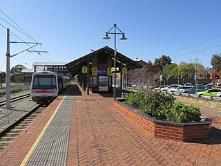
Sherwood railway station is a suburban railway station in Armadale, a suburb of Perth, Western Australia. It is on the Armadale line which is part of the Transperth network, and is 28.6 kilometres (17.8 mi) southwest of Perth station and 1.8 kilometres (1.1 mi) north of Armadale station. The station opened in 1973 as Kingsley, but was renamed to Sherwood in 1993. It consists of two side platforms with a pedestrian level crossing. It is not fully accessible due to steep ramps, wide gaps at the pedestrian level crossing, and wide gaps between the platform and train. Services are operated by Transperth Train Operations, a division of the state government's Public Transport Authority. Peak services reach seven trains per hour in each direction, whilst off-peak services are four trains per hour.

Challis railway station is a suburban railway station in Kelmscott, a suburb of Perth, Western Australia. It is on the Armadale line which is part of the Transperth network, and is 27.3 kilometres (17.0 mi) southwest of Perth station and 3.1 kilometres (1.9 mi) north of Armadale station. The station opened on 29 October 1973, as did the adjacent Sherwood station, filling the large gap between Armadale station and Kelmscott station. It consists of two side platforms with a pedestrian level crossing. It is not fully accessible due to steep ramps and wide gaps at the pedestrian level crossing.

Kelmscott Station is a railway station on the South Western Railway 25.9 kilometres from Perth Station in the suburb of Kelmscott. It is served by Armadale Line services which are part of the Transperth network.
Kelmscott is a southeastern suburb of Perth, Western Australia in the local government area of the City of Armadale. It is 23 kilometres (14 mi) southeast of Perth along the Albany Highway.

Wungong, pronounced is a semi-rural south-eastern suburb of Perth, Western Australia, located midway between Armadale and Byford and located in the local government area of the City of Armadale.
Mount Nasura is a suburb of Perth, Western Australia, located within the City of Armadale. The suburb occupies hilly terrain bounded on the north by Brookton Highway and Hill Street (1.6 km), west by Paterson Road (1.1 km), south-west by Canns and Carradine Roads (1.6 km), south by property boundaries on the north side of the Neerigin Brook (0.3 km), and east by Albany Highway (2.7m). With the exception of the Armadale Kelmscott District Memorial Hospital, the suburb is primarily residential.

Armadale is a Legislative Assembly electorate in the state of Western Australia. The district is named for the southeastern Perth suburb of Armadale, which falls within its borders.

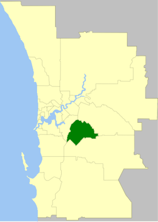
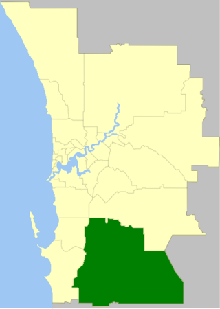
The City of Armadale is a local government area in the southeastern suburbs of the Western Australian capital city of Perth, about 28 kilometres (17.4 mi) southeast of Perth's central business district. The City covers an area of 560 square kilometres (216 sq mi), much of which is state forest rising into the Darling Scarp to the east, and had a population of almost 80,000 as at the 2016 Census.
Ian George Pratt was an Australian politician, and a member of the Western Australian Legislative Council from 1974 until 1986 representing the seat of Lower West Province for the Liberal Party.
Armadale Hospital is a general public hospital in Armadale, in Perth's south-eastern suburbs. The hospital, which includes an emergency department with 47 patient spaces, is located on the Armadale Health Service campus. The campus also includes Armadale's Community Health Service, Mental Health Service, and Aged Care and Rehabilitation Service.
Haynes is a suburb of Perth, Western Australia, located within the City of Armadale. This rural and semi-rural suburb is located on the city's fringe, and in the 2010s began to be subdivided for urban purposes.
Hugh Trevor Jones is an Australian politician and former Lieutenant Commander at the Royal Australian Navy. He was elected as the Member of Parliament for the electorate of Darling Range in the Western Australian Legislative Assembly for the Australian Labor Party at the 2021 state election.
References
- ↑ WA Electoral Commission, Municipality Boundary Amendments Register (release 3.0), 31 July 2007.