Related Research Articles

The local government areas of Western Australia (LGAs) are those areas, towns and districts in Western Australia that manage their own affairs to the extent permitted by the Local Government Act 1995. The Local Government Act 1995 also makes provision for regional local governments (referred to as "regional councils", established by two or more local governments for a particular purpose.

The City of Bayswater is a local government area in the Western Australian capital city of Perth, about 7 kilometres (4 mi) northeast of Perth's central business district. The City covers an area of 34.6 square kilometres (13.4 sq mi) and has a population of 65,050 as at the 2016 Census. The City of Bayswater is a member of the Eastern Metropolitan Regional Council.

The City of Melville is a local government area in the southern suburbs of the Western Australian capital city of Perth, east of the port city of Fremantle and about 12 kilometres (7.5 mi) south of Perth's central business district. The City covers an area of 52.73 square kilometres (20.36 sq mi) and had a population of about 98,000 as at the 2016 Census.

The City of Wanneroo is a local government area with city status in the northern suburbs of Perth, Western Australia. It is centred approximately 25 kilometres (15.5 mi) north of Perth's central business district and forms part of the northern boundary of the Perth metropolitan area. Wangara encompasses the federal divisions of Cowan, Moore and Pearce.

Blacktown City Council is a local government area in Western Sydney, situated on the Cumberland Plain, approximately 35 kilometres (22 mi) west of the Sydney central business district, in the state of New South Wales, Australia. Established in 1906 as the Blacktown Shire and becoming the Municipality of Blacktown in 1961 before gaining city status in 1979, the City occupies an area of 246.9 square kilometres (95.3 sq mi) and has a population of 366,534, making it the second most populous local government area in Sydney.

The Shire of Corrigin is a local government area in the Wheatbelt region of Western Australia, about 230 kilometres (143 mi) east of the state capital, Perth. Its seat of government is the town of Corrigin. The shire covers an area of 3,095 square kilometres (1,195 sq mi) and the economy, worth approximately $50 million per year to the state economy, is based on agriculture - predominantly cereal grains and sheep, with some supporting industries including a flour mill.

Narrandera Shire is a local government area in the Riverina region of south-western New South Wales, Australia. The Shire is located adjacent to the Sturt and Newell Highways.

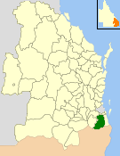
The Shire of Blackall was a local government area located in central Queensland around the town of Blackall. It covered an area of 16,366.8 square kilometres (6,319.3 sq mi), and existed as a local government entity from 1879 until 2008, when it amalgamated with neighbouring Shire of Tambo to form the Blackall-Tambo Region.
The Shire of Beaudesert was a local government area located in South East Queensland, Australia, stretching from the New South Wales border, along the Gold Coast hinterland to the urban fringes of the cities of Brisbane and Ipswich. The Shire covered an area of 2,854.3 square kilometres (1,102.1 sq mi), and existed from 1879 until its abolition on 15 March 2008, following which it was split between Logan City and the new Scenic Rim Region.

The Shire of Carnamah is a local government area located in the Mid West region of Western Australia, about 310 kilometres (193 mi) north of Perth, the state capital, and about 181 kilometres (112 mi) south of the city of Geraldton. The Shire covers an area of 2,876 square kilometres (1,110 sq mi) and its seat of government is the town of Carnamah.

The Shire of Cue is a local government area in the Mid West region of Western Australia, about 420 kilometres (260 mi) east-northeast of the port city of Geraldton and about 650 kilometres (400 mi) north-northeast of the state capital, Perth. The Shire covers an area of 13,623 square kilometres (5,260 sq mi), and its seat of government is the town of Cue.

The Shire of Leonora is a local government area in the Goldfields-Esperance region of Western Australia, about 240 kilometres (149 mi) north of the city of Kalgoorlie and about 830 kilometres (516 mi) northeast of the state capital, Perth. The Shire covers an area of 32,189 square kilometres (12,428 sq mi), and its seat of government is the town of Leonora.
References
- ↑ "Local Government Act, 1960. Declaration as a Town. Provisions Concerning Elections. (per L.G. 433/62)". Western Australia Government Gazette. 28 September 1962. p. 1962:2680-2681.
- ↑ "Local Government Act, 1960-1967. Order in Council". Western Australia Government Gazette. 3 May 1968. p. 1968:1245.
- 1 2 3 Uren, Malcolm (1975). The City of Melville : from bushland to expanding metropolis. Melville City Council. p. 145. ISBN 0959966927. Lists all chairmen, presidents and mayors up until 1975.