Related Research Articles

The Shire of Plantagenet is a local government area in the Great Southern region of Western Australia, managed from the town of Mount Barker, 360 kilometres (224 mi) south of Perth and 50 kilometres (31 mi) north of Albany. The shire covers an area of 4,792 square kilometres (1,850 sq mi) and includes the communities of Narrikup, Rocky Gully, Kendenup and Porongurup.

The Shire of Victoria Plains is a local government area in the Wheatbelt region of Western Australia, about 160 kilometres (100 mi) north of the state capital, Perth. It covers an area of 2,569 square kilometres (992 sq mi), and its seat of government is the town of Calingiri.

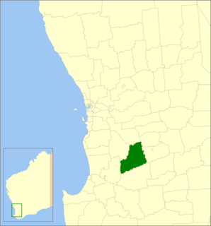
The Shire of Beverley is a local government area in the Wheatbelt region of Western Australia about 130 kilometres (80 mi) southeast of Perth, the state capital. The Shire covers an area of 2,372 square kilometres (916 sq mi), starting 20 kilometres (12 mi) outside Armadale in the Darling Scarp and extending eastwards beyond the scarp into agricultural lands which support broad acre activities such as livestock and cropping. Its seat of government is the town of Beverley, which accommodates just over half of the Shire's population.
The Shire of Williams is a local government area in the Wheatbelt region of Western Australia, about 161 kilometres (100 mi) southeast of the state capital, Perth. The Shire covers an area of 2,306 square kilometres (890 sq mi), and its seat of government is the town of Williams.

The Shire of Northam is a local government area in the Wheatbelt region of Western Australia, beyond the northeastern fringe of the Perth metropolitan area centred on the town of Northam itself. The Shire covers an area of 1,431 square kilometres (553 sq mi). In 2007, it merged with the Town of Northam, almost tripling its population in the process from a previous size of 3,794.
The Shire of Toodyay is a local government area in the Wheatbelt region of Western Australia, beyond the north-eastern limits of the Perth metropolitan area. The Shire covers an area of 1,694 square kilometres (654 sq mi), and its seat of government is the town of Toodyay.

The Shire of York is a local government area in the Wheatbelt region of Western Australia, covering an area of 2,133 square kilometres (824 sq mi) just beyond the eastern fringe of Perth's metropolitan area. The Shire's seat of government is the town of York.

The Shire of Kojonup is a local government area in the Great Southern region of Western Australia, about 250 kilometres (155 mi) southeast of the state capital, Perth, along Albany Highway. The Shire covers an area of 2,932 square kilometres (1,132 sq mi) and its seat of government is the town of Kojonup.

The Shire of Nungarin is a local government area in the Wheatbelt region of Western Australia, and with a population of 257 as at the 2016 census, is one of the nation's smallest. It is located about 40 kilometres (25 mi) north of Merredin and about 300 kilometres (186 mi) east of the state capital, Perth. The Shire covers an area of 1,164 square kilometres (449 sq mi), and its seat of government is the town of Nungarin.

The Shire of Dandaragan is a local government area located in the Wheatbelt region of Western Australia, about 200 kilometres (124 mi) north of the state capital, Perth. The Shire covers an area of 6,716 square kilometres (2,593 sq mi) and its seat of government is the town of Jurien Bay.

The Shire of Manjimup is a local government area in the South West region of Western Australia, about 320 kilometres (200 mi) south of the state capital, Perth. The Shire covers an area of 7,027 square kilometres (2,713 sq mi), and its seat of government is the town of Manjimup.

The Shire of Dalwallinu is a local government area in the Wheatbelt region of Western Australia, about 250 kilometres (155 mi) NNE of Perth, the state capital. The Shire covers an area of 7,236 square kilometres (2,794 sq mi) and its seat of government is the town of Dalwallinu.

The Shire of Cue is a local government area in the Mid West region of Western Australia, about 420 kilometres (260 mi) east-northeast of the port city of Geraldton and about 650 kilometres (400 mi) north-northeast of the state capital, Perth. The Shire covers an area of 13,623 square kilometres (5,260 sq mi), and its seat of government is the town of Cue.

The Shire of Irwin is a local government area in the Mid West region of Western Australia, about 50 kilometres (30 mi) south of Geraldton and about 360 kilometres (220 mi) north of the state capital, Perth. The Shire covers an area of 2,374 square kilometres (917 sq mi), and its seat of government is the town of Dongara.

The Shire of Meekatharra is a local government area in the Mid West region of Western Australia, about halfway between the town of Port Hedland and the state capital, Perth, Western Australia. The Shire covers an area of 100,789 square kilometres (38,915 sq mi), and its seat of government is the town of Meekatharra.

The Shire of Northampton is a local government area in the Mid West region of Western Australia, about 50 kilometres (30 mi) north of Geraldton and about 460 kilometres (290 mi) north of the state capital, Perth. The Shire covers an area of 13,738 square kilometres (5,304 sq mi), and its seat of government is the town of Northampton, with the largest settlement being Kalbarri.
References
- ↑ "Road Board Districts". Western Australia Government Gazette. 24 January 1871. p. 1871:11.