Related Research Articles

There are 137 local government areas (LGAs) in Western Australia, which comprise 27 cities, 102 shires, and 8 towns that manage their own affairs to the extent permitted by the Local Government Act 1995. The Local Government Act 1995 also makes provision for regional local governments (referred to as "regional councils", established by two or more local governments for a particular purpose.

The City of Bayswater is a local government area in the Western Australian capital city of Perth, about 7 kilometres (4 mi) northeast of Perth's central business district. The city covers an area of 34.6 square kilometres (13.4 sq mi) and had a population of 69,283 as at the 2021 Census. The City of Bayswater is a member of the Eastern Metropolitan Regional Council.

The City of Cockburn is a local government area in the southern suburbs of the Western Australian capital city of Perth about 8 kilometres (5 mi) south of Fremantle and about 24 kilometres (15 mi) south of Perth's central business district. The City covers an area of 167.5 square kilometres (64.7 sq mi) and had a population of over 104,000 as at the 2016 Census.

The City of Wanneroo is a local government area with city status in the northern suburbs of Perth, Western Australia. It is centred approximately 25 kilometres (15.5 mi) north of Perth's central business district and forms part of the northern boundary of the Perth metropolitan area. Wanneroo encompasses the federal divisions of Cowan, Moore and Pearce.
Tamala Park is an unpopulated locality in Perth, Western Australia. It sits on the border between the City of Wanneroo and the City of Joondalup local authorities, and separates the Clarkson-Butler region from the suburbs of Joondalup.

Wanneroo Road is a 44-kilometre (27 mi) arterial highway in the northern suburbs of Perth, Western Australia linking Joondanna and Yokine in the south with Wanneroo and Yanchep in the north. As part of State Route 60, it begins from Charles Street in the inner city and becomes Indian Ocean Drive up to Dongara.
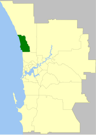
The City of Joondalup is a local government area in Perth, Western Australia. Its central business district is located in the suburb Joondalup, and it includes the town centres of Hillarys and Warwick.
Mindarie was an electoral district of the Legislative Assembly in the Australian state of Western Australia. The district was named for the outer northern Perth suburb of Mindarie, which falls within its borders.

The Shire of Wyndham East Kimberley is one of the four local government areas in the Kimberley region of northern Western Australia, covering an area of 117,514 square kilometres (45,372 sq mi) at Western Australia's northeastern corner. The Shire's seat of government was originally in Wyndham but now in the town of Kununurra, which is home to over half of the Shire's permanent population of around 7,000, while a council office is located at Wyndham.
Joondalup Drive is a major distributor road in the northern suburbs of Perth, Western Australia. The road travels through the City of Joondalup's central business district and extends for a few kilometres east through neighbouring residential suburbs in the City of Wanneroo. The road was extended in 2005 to the northern suburb of Banksia Grove to provide easy access for residents to Joondalup's city centre, and to provide a complete connecting route to the Brand Highway from the Mitchell Freeway.

The Shire of Beverley is a local government area in the Wheatbelt region of Western Australia about 130 kilometres (80 mi) southeast of Perth, the state capital. The Shire covers an area of 2,372 square kilometres (916 sq mi), starting 20 kilometres (12 mi) outside Armadale in the Darling Scarp and extending eastwards beyond the scarp into agricultural lands which support broad acre activities such as livestock and cropping. Its seat of government is the town of Beverley, which accommodates just over half of the Shire's population.

The Shire of Croydon is a local government area in western Queensland, Australia. The shire, administered from the town of Croydon, covers an area of 29,498 square kilometres (11,389.2 sq mi). The council consists of a mayor plus four councillors, each of whom represents the entire Shire.

The Shire of Laverton is a local government area in the Goldfields-Esperance region of Western Australia, about 370 kilometres (230 mi) northeast of the city of Kalgoorlie and about 950 kilometres (590 mi) east-northeast of the state capital, Perth. The Shire covers an area of 179,798 square kilometres (69,420 sq mi), and its seat of government is the town of Laverton.

Marangaroo Drive is an arterial east-west road located in the northern suburbs of Perth, Western Australia. This road was originally part of Warwick Road, but in the late 1970s, Warwick Road was realigned, so the section of Warwick Road that was east of Wanneroo Road was discontinuous with the part that was west. The part that was east was renamed Marangaroo Drive, after the suburb Marangaroo. Marangaroo Drive is now extended through the suburb of Ballajura so it connects with Hepburn Avenue.

Henrietta 'Rita' Waters JP was a former farmer, and wool classer who in 1994 was the first woman elected Mayor of the City of Wanneroo. Waters was also the first woman elected to the position of Deputy Mayor of the City of Wanneroo in 1989. Rita Waters was a Councillor for the City of Wanneroo, for 10 years, from May 1986 to May 1996. Waters represented North Ward, which included the suburbs of Two Rocks, Yanchep, Eglinton, Alkimos, Carabooda and Jindalee.
References
- ↑ "Local Government Act 1960 — City of Wanneroo (City Status) Order 1985". Western Australia Government Gazette. 19 July 1985. p. 1985:2514.
- ↑ "City of Wanneroo Extraordinary Election – 2 September 2022" . Retrieved 3 September 2022.
- ↑ "The Road Districts Act, 1919–1948. Wanneroo Road District. Appointment of Commissioner. Order in Council. (per LG 431/50)". Western Australia Government Gazette. 24 March 1950. p. 1950:713.
* "The Road Districts Act, 1919–1948. Road Board Election". Western Australia Government Gazette. 4 July 1950. p. 1950:1564. - ↑ "Road Districts Act, 1919–1956. Wanneroo Road District. Appointment of Commissioner. Order in Council. (per LG 2023/52)". Western Australia Government Gazette. 17 December 1957. p. 1957:3673.
- ↑ "City of Wanneroo (Suspension of Council and Appointment of Commissioners) Order 1997". Western Australia Government Gazette. 12 November 1997. p. 1997:6411.
- ↑ "City of Wanneroo (Reinstatement of Council) Order 1998". Western Australia Government Gazette. 26 June 1998. p. 1998:3430.
* "Joondalup and Wanneroo Order 1998". Western Australia Government Gazette. 26 June 1998. p. 1998:3431–3444.