Related Research Articles

There are 137 local government areas (LGAs) of Western Australia, which comprise 27 cities, 102 shires, and 8 towns that manage their own affairs to the extent permitted by the Local Government Act 1995. The Local Government Act 1995 also makes provision for regional local governments (referred to as "regional councils", established by two or more local governments for a particular purpose.

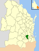
The Shire of Burdekin is a local government area located in North Queensland, Australia in the Dry Tropics region. The district is located between Townsville and Bowen in the delta of the Burdekin River.

Wyong Shire was a local government area located in the Central Coast region of New South Wales, Australia. The incorporation of the Wyong area dates back to 7 March 1906 when the entire area of the Brisbane Water Police District outside of the Town of Gosford was proclaimed as the Erina Shire. From 1 January 1947, local government in the Central Coast region was reorganised, creating Gosford Shire and Wyong Shire, which comprised Erina Shire north and east of Kulnura, Central Mangrove and Lisarow.

The Shire of Moora is a local government area in the northern Wheatbelt region of Western Australia, and generally lies between the Brand Highway and Great Northern Highway about 180 kilometres (112 mi) north of Perth, the state capital. The Shire covers an area of 3,767 square kilometres (1,454 sq mi) and its seat of government is the town of Moora.

The Local Government Act 1888 was an Act of Parliament which established county councils and county borough councils in England and Wales. It came into effect on 1 April 1889, except for the County of London, which came into existence on 21 March at the request of the London County Council.
Stoneville is a suburb east of Perth in the Shire of Mundaring, Western Australia. It is named after Edward Albert Stone, who was Chief Justice of Western Australia when the place was named in 1905. The name was chosen by the local residents, who were developing the district for fruit growing. The town's population is 2,050, with a median age of 36 years and 7.1% of residents aged over 65.

The Shire of Beverley is a local government area in the Wheatbelt region of Western Australia about 130 kilometres (80 mi) southeast of Perth, the state capital. The Shire covers an area of 2,372 square kilometres (916 sq mi), starting 20 kilometres (12 mi) outside Armadale in the Darling Scarp and extending eastwards beyond the scarp into agricultural lands which support broad acre activities such as livestock and cropping. Its seat of government is the town of Beverley, which accommodates just over half of the Shire's population.

The Shire of Peppermint Grove is a local government area in Perth, Western Australia, 12 kilometres (7.5 mi) southwest of the Perth central business district. At 1.1 km2 (0.42 sq mi), it is the smallest local government area in Australia; it contains only the eponymous suburb, Peppermint Grove. The council comprises seven elected councillors, with no ward divisions.

The Shire of Mundaring is a local government area in eastern metropolitan Perth, the capital of Western Australia. The Shire covers an area of 645 square kilometres (249 sq mi) and had a population of approximately 38,000 as at the 2016 Census.
The Shire of Gatton was a local government area located in the Lockyer Valley region between the cities of Toowoomba and Ipswich, and about 90 kilometres (56 mi) west of Brisbane, the state capital of Queensland, Australia. The shire covered an area of 1,571.8 square kilometres (606.9 sq mi), and existed from 1880 until its merger with the Shire of Laidley to form the Lockyer Valley Region on 15 March 2008.
Essex County Council is the county council that governs the non-metropolitan county of Essex in England. It has 75 councillors, elected from 70 divisions, and has been under Conservative majority control since 2001. The council meets at County Hall in the centre of Chelmsford. It is a member of the East of England Local Government Association.

Local government in the Australian state of Victoria consists of 79 local government areas (LGAs). Also referred to as municipalities, Victorian LGAs are classified as cities (34), shires (38), rural cities (6) and boroughs (1). In general, an urban or suburban LGA is called a city and is governed by a City Council, while a rural LGA covering a larger rural area is usually called a shire and is governed by a Shire Council. Local councils have the same administrative functions and similar political structures, regardless of their classification.

The Central Coast Council is a local government area in the Central Coast region of New South Wales, Australia. It is adjacent to the Pacific Highway, Central Coast Highway, the Northern railway line and the Pacific Ocean. The council was formed on 12 May 2016 following the merger of the Gosford City and Wyong Shire Councils.
References
- Elliot, Ian (1983). Mundaring – A History of the Shire. Shire of Mundaring.