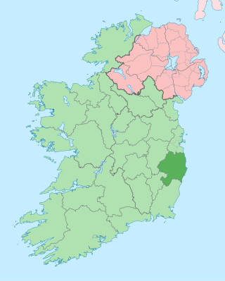
County Dublin is one of the thirty-two traditional counties of Ireland, located on the island's east coast, within the province of Leinster. The county no longer delimits an area of local government having been abolished in 1994. The former county is divided into three modern counties and the city of Dublin. The four areas form a NUTS III statistical region of Ireland.

Dublin is the capital and largest city of Ireland. On a bay at the mouth of the River Liffey, it is in the province of Leinster, bordered on the south by the Dublin Mountains, a part of the Wicklow Mountains range. At the 2022 census, it had a population of 1,263,219, while County Dublin as a whole had a population of 1,458,154, and the population of the Greater Dublin Area was over 2 million, or roughly 40% of the Republic of Ireland's total population.
County Wicklow is a county in Ireland. The last of the traditional 32 counties, having been formed as late as 1606, it is part of the Eastern and Midland Region and the province of Leinster. It is bordered by the Irish Sea to the east and the counties of Wexford to the south, Carlow to the southwest, Kildare to the west, and South Dublin and Dún Laoghaire–Rathdown to the north.

Leinster is one of the four provinces of Ireland, situated in the southeast and east of Ireland.
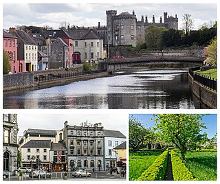
Kilkenny is a city in County Kilkenny, Ireland. It is located in the South-East Region and in the province of Leinster. It is built on both banks of the River Nore. The 2016 census gave the population of Kilkenny as 26,512.

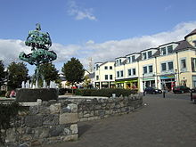
Swords, the county town of Fingal, is a large suburban town on the east coast of Ireland, situated ten kilometres north of Dublin city centre. The town was reputedly founded c. AD 560. Located on the Ward River, Swords features Swords Castle, a restored medieval castle, a holy well from which it takes its name, a round tower and a Norman tower. Facilities in the area include the Pavilions shopping centre, one of the largest in the Dublin region, a range of civic offices, some light industries, the main storage facility and archive of the National Museum of Ireland and several parks. Dublin Airport is located nearby.
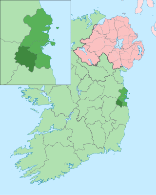
South Dublin is a county in Ireland, within the province of Leinster and the Eastern and Midland Region. It is one of three successor counties to County Dublin, which was disestablished for administrative purposes in 1994. South Dublin County Council is the local authority for the county. The county contains both dense suburbs of Dublin and stretches of unpopulated mountain. In 2016 it had a population of 278,767, making it the third most populous county in the state.
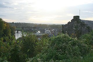
Thomastown, historically known as Grennan, is a town in County Kilkenny in the province of Leinster in the south-east of Ireland. It is a market town along a stretch of the River Nore which is known for its salmon and trout, with a number of historical landmarks in the vicinity. Visitor attractions include Jerpoint Abbey, Kilfane Glen gardens, and Mount Juliet Golf Course.

The documented history of Islam in the Republic of Ireland dates back to the 1950s. The number of Muslims in the Republic of Ireland has increased since the 1990s, mostly through immigration. According to the 2022 Irish census, the number of Muslims resident in the Republic was 81,930.

Urlingford is a town, as well as a civil parish within the barony of Galmoy. It is located in the north west of County Kilkenny, along the boundary with County Tipperary, in Leinster, Ireland.

The Greater Dublin Area, or simply Greater Dublin, is an informal term that is taken to include the city of Dublin and its hinterland, with varying definitions as to its extent. At the expansive end, it has been defined as including all of the traditional County Dublin and three neighbouring counties, while more commonly it is taken as the contiguous metropolitan area of Dublin plus suburban and commuter towns. The area is defined for strategic planning, and, for example, transport, and it is not a formal administrative or political unit.

Ballyhale is a village in the south east of Ireland. Located in the south of County Kilkenny, south of the city of Kilkenny and roughly halfway to Waterford city.

Lusk is a small town in Fingal, Ireland. The town is located about 20 km (12 mi) north of Dublin city centre.

Kinsealy is an outer suburb of Dublin in Fingal, Ireland. Kinsealy is on the northside of the city, about 7 km from the city centre, on the Malahide Road, in the former green belt between the suburbs of Balgriffin, Portmarnock and Malahide.

Limerick is the third largest city in the Republic of Ireland and is the capital of Ireland's Mid-West Region comprising the counties of Limerick, Clare and North Tipperary. Traditionally Limerick's economy was mainly agricultural of which a lot of industry in the city was based around due to the city's proximity to the Golden Vale. Important industries at this time were the bacon industry and Limerick lace which provided much employment. Limerick Port was also the main port on the west of Ireland where much this produce was exported. Today Limerick's economy is driven by a cluster of industrial and business parks located along the Limerick/Shannon corridor which include the National Technology Park, Raheen Business Park and the Shannon Free Zone. Limerick/Shannon is also classified as a gateway city as part of the National Spatial Strategy.

The South-East is a strategic planning area within the Southern Region in Ireland. It is a NUTS Level III statistical region of Ireland. It comprises the counties of Carlow, Kilkenny and Wexford and the city and county of Waterford. The South-East spans 7,198 km2, 10.2% of the total area of the state and according to the 2016 census had a population of 422,062.

The Mid-West is a strategic planning area within the Southern Region in Ireland. It is a NUTS Level III statistical region of Ireland. It consists of the counties of Clare and Tipperary, and the city and county of Limerick. Limerick City is the economic centre of the region. It spans 10,511 km2, 14.95% of the total area of the state and as of the 2016 census, it had a 2016 population of 473,269.