Kingsley is a civil parish in Cheshire West and Chester, England. Other than the village of Kingsley, the parish is entirely rural. It contains 13 buildings that are recorded in the National Heritage List for England as designated listed buildings. Other than the church and its lychgate, and the wall of a former Quaker burial ground, the structures are all related to domestic buildings or farms.
Norley is a civil parish in Cheshire West and Chester, England. Other than the village of Norley, it is entirely rural. The parish contains three buildings that are recorded in the National Heritage List for England as designated listed buildings. These consist of a country house, a church, and a monument in the churchyard.
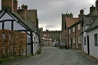
Great Budworth is a civil parish in Cheshire West and Chester, England. The parish contains 59 buildings that are recorded in the National Heritage List for England as designated listed buildings. Other than the village of Great Budworth, the parish is entirely rural. Most of the listed buildings are houses, or buildings relating to farming, a high proportion of which are located within the village itself. The village is described by Norman Bilsborough as being "probably one of the best-known villages in Cheshire", and Claire Hartwell et al. writing about the village in the Buildings of England series state "the immediate surroundings of the church make one of the best pieces of villagescape in the county". The village is located in what was part of the estate of Arley Hall. Between the 1860s and the end of the 19th century the owner of the hall, Rowland Egerton-Warburton, commissioned the restoration of existing buildings in the village and the construction of new ones. To this end he employed architects working in the Vernacular Revival style, including John Douglas, Edmund Kirby, and William Eden Nesfield. Douglas' biographer Edward Hubbard states that Egerton-Warburton had a "campaign to restore the village and render it picturesque in Victorian eyes". Almost all the buildings in the centre of the village, those in Main Street, Church Street, and School Lane, are listed.
Davenham is a civil parish in Cheshire West and Chester, England. It contains 28 buildings that are recorded in the National Heritage List for England as designated listed buildings. Other than the village of Davenham, the parish is rural, and most of the buildings in the list are domestic or related to farming. Running through the parish are the Trent and Mersey Canal, the River Weaver and the Weaver Navigation, and the West Coast Main Line; there are structures relating to all these in the list. The other listed buildings are the village church and associated structures, two public houses, and a memorial drinking fountain.
Capenhurst is a civil parish in Cheshire West and Chester, England. It contains three buildings that are recorded in the National Heritage List for England as designated listed buildings, all of which are at Grade II. This grade is the lowest of the three gradings given to listed buildings and is applied to "buildings of national importance and special interest". The listed buildings consist of a church, a pinfold, and a guidepost.

Christleton is a civil parish in Cheshire West and Chester, England. It contains 32 buildings that are recorded in the National Heritage List for England as designated listed buildings. Of these, three are listed at Grade II*, and the others at Grade II. The largest settlement in the parish is the village of Christleton, and most of the listed buildings are in the village. These include houses with related structures, the church and items in the churchyard, almshouses, a memorial shelter, and a telephone kiosk. The Shropshire Union Canal passes through the parish, and three of its bridges are listed. Also listed is a former hydraulic sewage lift.
Mollington is a civil parish in Cheshire West and Chester, England. It contains ten buildings that are recorded in the National Heritage List for England as designated listed buildings, all of which are at Grade II. This grade is the lowest of the three gradings given to listed buildings and is applied to "buildings of national importance and special interest". Apart from the village of Mollington, the parish is rural. The listed buildings include houses, farmhouses, a farm building, a sundial, an icehouse, a guidepost, a canal bridge, and a railway viaduct.
Puddington is a civil parish in Cheshire West and Chester, England. It contains 12 buildings that are recorded in the National Heritage List for England as designated listed buildings. Of these, one is listed at Grade II*, the middle grade, and the others are at Grade II. Apart from the village of Puddington, the parish is entirely rural. Nine of the listed buildings are houses, or structures related to houses or farming, the other three being footpath guideposts. All of these were erected by the Wirral Footpaths Preservation Society towards the end of the 19th century, or at the beginning of the 20th century. They all bear an inscription on the shaft.
There are over 20,000 Grade II* listed buildings in England. This page is a list of these buildings in the unitary authority of Cheshire West and Chester.

Saughall is a former civil parish now in the parishes of Saughall and Shotwick Park, Puddington and the unparished area of Chester, in Cheshire West and Chester, England. It contains eleven buildings that are recorded in the National Heritage List for England as designated listed buildings, all of which are listed at Grade II. This grade is the lowest of the three gradings given to listed buildings and is applied to "buildings of national importance and special interest". The parish contains the village of Saughall, and is otherwise rural. Most of the listed buildings are houses and associated structures. The others include a former inn, a former windmill, a church, and two guideposts.
Shotwick is a former civil parish, now in the parish of Puddington, in Cheshire West and Chester, England. It contains 23 buildings that are recorded in the National Heritage List for England as designated listed buildings. Of these, one is listed at Grade I, the highest grade, two are listed at Grade II*, the middle grade, and the others are at Grade II. Apart from the village of Shotwick, the parish is entirely rural. Most of the listed buildings are in the village, and include houses, St Michael's Church and structures in the churchyard, and Shotwick Hall with associated structures. Outside the village, the listed buildings are domestic or related to farming.
Tilstone Fearnall is a former civil parish, now in the parishes of Tiverton and Tilstone Fearnall and Rushton, in Cheshire West and Chester, England. It contains nine buildings that are recorded in the National Heritage List for England as designated listed buildings, all of which are listed at Grade II. This grade is the lowest of the three gradings given to listed buildings and is applied to "buildings of national importance and special interest". Apart from the village of Tilstone Fearnall, the parish is rural. The Shropshire Union Canal passes through the parish, and three of the listed building are associated with it, a bridge, a lock, and a linkman's hut. The other listed buildings include a church, a vicarage, a former mill, and houses and associated structures.
Acton is a former civil parish in Cheshire East, England. It contained 24 buildings that are recorded in the National Heritage List for England as designated listed buildings. Of these, two are listed at Grade I, the highest grade, four are listed at Grade II*, the middle grade, and the others are at Grade II. Apart from the village of Acton, the parish was rural. Listed buildings in the village include the church and associated structures, houses, a public house and a telephone kiosk. The major structure is the parish is Dorfold Hall; this and associated structures are listed. The other items include an aqueduct carrying the Shropshire Union Canal across a road, farmhouses and cottages.
Baddiley is a civil parish in Cheshire East, England. It contains nine buildings that are recorded in the National Heritage List for England as designated listed buildings. Of these, one is listed at Grade I, the highest grade, and the others are at Grade II. Apart from the village of Baddily, the parish is entirely rural. The listed buildings consist of the village church, houses and farm buildings. The Llangollen Canal runs through the parish, and the three locks on the canal in the parish are also listed.
Brereton is a civil parish in Cheshire East, England. It contains 21 buildings that are recorded in the National Heritage List for England as designated listed buildings. Of these, one is listed at Grade I, the highest grade, three are listed at Grade II*, the middle grade, and the others are at Grade II. The parish is almost entirely rural. The major building in the parish is Brereton Hall. The listed buildings consist of the hall and associated buildings, the church and a sundial in its churchyard, a public house, a former mill, farmhouses and farm buildings, houses or cottages, and three mileposts.
Cranage is a civil parish in Cheshire East, England. It contains 12 buildings that are recorded in the National Heritage List for England as designated listed buildings. Of these, one is listed at Grade II*, the middle grade, and the others are at Grade II. Apart from the village of Cranage, and some residential areas, the parish is rural. Most of the listed buildings are houses and cottages, or farmhouses and farm buildings. The other listed buildings are a former country house, a former vicarage, a school, a bridge, and a milepost.
Gawsworth is a civil parish in Cheshire East, England. It contains 20 buildings that are recorded in the National Heritage List for England as designated listed buildings. Of these, three are listed at Grade I, the highest grade, two are listed at Grade II*, the middle grade, and the others are at Grade II. Apart from the village of Gawsworth, the parish is rural. The most important buildings in the parish, all listed at Grade I, are Gawsworth Old Hall and associated structures, St James' Church, also with associated structures, and the Old Rectory. Listed at Grade II* are Gawsworth New Hall and an associated barn. The Macclesfield Canal runs through the parish, and there are three listed structures associated with this, two bridges and a milestone. The other listed buildings are houses, farm buildings, a grave, a public house, a war memorial, and a boundary stone.
Peover Superior is a former civil parish in Cheshire East, England. It contained 29 buildings that are recorded in the National Heritage List for England as designated listed buildings. Of these, two are listed at Grade I, the highest grade, one is listed at Grade II*, the middle grade, and the others are at Grade II. The parish was mainly rural, and most of the listed buildings are houses of various sizes, farmhouses, cottages, and associated structures. The other listed buildings include a church with associated structures, a former water mill, a railway viaduct, and a mile post.
Pott Shrigley is a civil parish in Cheshire East, England. It contains 19 buildings that are recorded in the National Heritage List for England as designated listed buildings. Of these, one is listed at Grade I, the highest grade, one is listed at Grade II*, the middle grade, and the others are at Grade II. Apart from the village of Pott Shrigley, the parish is almost entirely rural. Most of the listed buildings are farmhouses and farm buildings, houses and cottages. Parts of the Macclesfield Canal run through the parish, and the listed buildings associated with this are a bridge, an aqueduct, and fence posts. The other listed structures are a church and churchyard cross, a school, a hotel and leisure centre, a telephone kiosk, and a parish boundary stone.
Prestbury is a civil parish in Cheshire East, England. It contains 51 buildings that are recorded in the National Heritage List for England as designated listed buildings. Of these, one is listed at Grade I, the highest grade, three are listed at Grade II*, the middle grade, and the others are at Grade II. Many of the listed buildings are in the village of Prestbury, including houses, a church and associated structures, shops, a bank, hotels, a public house, the village stocks, the entrance to a railway tunnel, and a telephone kiosk. In the surrounding countryside the listed buildings are more houses, farms and farm buildings, parish boundary stones, an ancient cross, and mileposts.


