
Rivington in the Borough of Chorley, Lancashire, is situated on the edge of the West Pennine Moors, at the foot of Rivington Pike overlooking reservoirs created for Liverpool Corporation Waterworks in the 19th century. Of the twenty-one listed buildings in the village, two are classified by English Heritage as Grade II*, the rest as Grade II; Rivington has no Grade I Listed buildings.
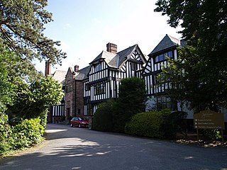
Inglewood is a house to the north-west of the village of Ledsham, Cheshire, England. It was built in 1909, but is dated 1915. The house was built for F. H. Fox, a Liverpool millionaire who made his fortune in marine insurance. The house later became a training centre. As of 2011 it is a hotel called Inglewood Manor Hotel. The house is mainly half-timbered, with stone dressings, and brick chimneys decorated with diapering. It is roofed with Lakeland slate. Its architectural style is late Arts and Crafts. The house has a rectangular plan, with three fronts in two and three storeys. The entrance is on the east front, which has eight bays; the south and west fronts each have five bays. On the south side is a balcony overlooking the gardens. The house is recorded in the National Heritage List for England as a designated Grade II listed building. Also listed Grade II are the south and west terrace walls of the garden, and the east terrace walls and a pergola.
Utkinton is a former civil parish, now in the parishes of Utkinton and Cotebrook and Tarporley, in Cheshire West and Chester, England. It is entirely rural, and contains the villages of Utkinton and Cotebrook. The A49 road runs through it in a north-south direction. The parish contains 13 buildings that are recorded in the National Heritage List for England as designated listed buildings. One of these, Utkinton Hall, is listed at Grade I, and all the others are in Grade II. Other than the hall, some of the listed buildings are associated with the hall, and the others are domestic buildings, or related to farming. In Cotebrook, the church and its former parsonage are listed.

Bath and North East Somerset is a unitary authority created on 1 April 1996, following the abolition of the County of Avon, which had existed since 1974. Part of the ceremonial county of Somerset, Bath and North East Somerset occupies an area of 220 square miles (570 km2), two-thirds of which is green belt. It stretches from the outskirts of Bristol, south into the Mendip Hills and east to the southern Cotswold Hills and Wiltshire border. The city of Bath is the principal settlement in the district, but BANES also covers Keynsham, Midsomer Norton, Radstock and the Chew Valley. The area has a population of 170,000, about half of whom live in Bath, making it 12 times more densely populated than the rest of the area.

North Somerset is a unitary authority in the ceremonial county of Somerset, England. As a unitary authority, North Somerset is administered independently of the non-metropolitan county of Somerset. Its administrative headquarters are located in the town hall of Weston-super-Mare.

Ince is a civil parish in Cheshire West and Chester, England. It contains 25 buildings that are recorded in the National Heritage List for England as designated listed buildings. One is these is of these listed at Grade I, the highest grade, one at Grade II*, the middle grade, and the rest are at the lowest grade, Grade II.
Mollington is a civil parish in Cheshire West and Chester, England. It contains ten buildings that are recorded in the National Heritage List for England as designated listed buildings, all of which are at Grade II. This grade is the lowest of the three gradings given to listed buildings and is applied to "buildings of national importance and special interest". Apart from the village of Mollington, the parish is rural. The listed buildings include houses, farmhouses, a farm building, a sundial, an icehouse, a guidepost, a canal bridge, and a railway viaduct.
Ightenhill is a civil parish in the borough of Burnley, Lancashire, England. The parish contains 15 buildings that are recorded in the National Heritage List for England as designated listed buildings. Of these, two are listed at Grade I, the highest of the three grades, and the others are at Grade II, the lowest grade. The parish is partly rural, and partly residential as a district of the town of Burnley. The most notable buildings in the parish are Gawthorpe Hall and its Great Barn. These are both listed, as are structures associated with them. The other listed buildings include a farmhouse dating from the 16th century, a former schoolmaster's house, a parish church and its churchyard wall, a drinking fountain, and two boundary stones.
Over Wyresdale is a civil parish in Lancaster, Lancashire, England. It contains 53 buildings that are recorded in the National Heritage List for England as designated listed buildings. Of these, one is at Grade II*, the middle grade, and the others are at Grade II, the lowest grade.
Bashall Eaves is a civil parish in Ribble Valley, Lancashire, England. It contains 22 listed buildings that are recorded in the National Heritage List for England. Of these, three are at Grade II*, the middle grade, and the others are at Grade II, the lowest grade. The parish contains the village of Bashall Eaves, and is otherwise rural. The most important building in the parish is Bashall Hall; this and structures are associated with it are listed. Most of the other listed buildings are houses and associated structures, farmhouses and farm buildings. In addition, three bridges and a public house are listed.
Billington and Langho is a civil parish in Ribble Valley, Lancashire, England. It contains nine listed buildings that are recorded in the National Heritage List for England. Of these, two are listed at Grade I, the highest of the three grades, one is at Grade II*, the middle grade, and the others are at Grade II, the lowest grade. The parish contains the villages of Billington and Langho, and is otherwise mainly rural. The listed buildings are houses, farmhouses, a farm building, and a church.
Easington is a civil parish in Ribble Valley, Lancashire, England. It contains nine listed buildings that are recorded in the National Heritage List for England. Of these, one is at Grade II*, the middle grade, and the others are at Grade II, the lowest grade. The parish is entirely rural. The oldest listed building is a medieval cross base, and the most important is Hammerton Hall, a country house. The other listed buildings are all farmhouses or farm buildings.
Newton is a civil parish in Ribble Valley, Lancashire, England. It contains 28 listed buildings that are recorded in the National Heritage List for England. Of these, one is at Grade II*, the middle grade, and the others are at Grade II, the lowest grade. The parish contains the village of Newton-in-Bowland, and is otherwise rural. The listed buildings are mainly houses with associated structures, farmhouses, and farm buildings, both in the village and in the surrounding countryside. The other listed buildings include bridges, a public house, a Friends' meeting house, and a former school.
Simonstone is a civil parish in Ribble Valley, Lancashire, England. It contains 22 listed buildings that are recorded in the National Heritage List for England. All of the listed buildings are designated at Grade II, the lowest of the three grades, which is applied to "buildings of national importance and special interest". The parish contains the village of Simonstone and surrounding countryside. The listed buildings are almost all houses and associated structures, or farmhouses and farm buildings, the others being a milestone and a former toll house.
Wrightington is a civil parish in the West Lancashire district of Lancashire, England. It contains 35 buildings that are recorded in the National Heritage List for England as designated listed buildings. Of these, four are at Grade II*, the middle grade, and the others are at Grade II, the lowest grade. The parish is mainly rural, and contains the village of Appley Bridge and the community of Wrightington Bar. A high proportion of the listed buildings in the parish are houses or cottages and associated structures, or farmhouses and farm buildings. The Leeds and Liverpool Canal runs though the parish and two of its locks are listed. The other listed buildings include churches, a school, a bridge, and a milestone.
Setmurthy is a civil parish in the Borough of Allerdale in Cumbria, England. It contains nine listed buildings that are recorded in the National Heritage List for England. Of these, one is listed at Grade II*, the middle of the three grades, and the others are at Grade II, the lowest grade. The parish is almost entirely rural, and the listed buildings consist of a country house and associated structures, farmhouses and farm buildings, a church, and a bridge.
St Bees is a civil parish in the Borough of Copeland, Cumbria, England. It contains 38 buildings that are recorded in the National Heritage List for England. Of these, four are listed at Grade I, the highest of the three grades, two are at Grade II*, the middle grade, and the others are at Grade II, the lowest grade. The parish includes the village of St Bees and the surrounding coastline and countryside. In the 12th century a Benedictine priory was established in the parish. Most of this disappeared after the Dissolution of the Monasteries apart from the priory church, most of which became the Church of St Mary and St Bega, the parish church of the village, while most of the chancel was modified for other uses. Also in the village is St Bees School, an independent school. The church, the school, and a number of associated structures are listed. Most of the other listed buildings are houses and associated structures, and farmhouses and farm buildings. The other listed buildings include a bridge, a signal box, and two war memorials.
Great Salkeld is a civil parish in the Eden District, Cumbria, England. It contains 23 listed buildings that are recorded in the National Heritage List for England. Of these, two are listed at Grade II*, the middle of the three grades, and the others are at Grade II, the lowest grade. The parish contains the village of Great Salkeld and he surrounding countryside. The listed buildings comprise houses and associated structures, farmhouses and farm buildings, a church and items in the churchyard, a folly, a war memorial, and a telephone kiosk.
Warburton is a civil parish in the Metropolitan Borough of Trafford, Greater Manchester, England. It contains 22 listed buildings that are recorded in the National Heritage List for England. Of these, one is listed at Grade I, the highest of the three grades, and the others are at Grade II, the lowest grade. The parish contains the village of Warburton, and is otherwise rural. Most of the listed buildings are houses, farmhouses and farm buildings. The other listed buildings include churches and associated structures, a war memorial, and an enclosure containing stocks and a cross base, with its wall also listed.
Onibury is a civil parish in Shropshire, England. It contains 25 listed buildings that are recorded in the National Heritage List for England. Of these, two are at Grade II*, the middle of the three grades, and the others are at Grade II, the lowest grade. The parish contains the village of Onibury and the surrounding countryside. Most of the listed buildings are houses, cottages, farm houses and farm buildings, the earliest of which are timber framed. The oldest building is a church, which is listed together with items in the churchyard. In the parish are a country house and a mansion, both of which are listed, together with associated structures. The other listed buildings include a gazebo, a former railway station, a war memorial, and a telephone kiosk.

