Listed buildings in Rowsley

Last updated

Rowsley is a civil parish in the Derbyshire Dales district of Derbyshire, England. The parish contains 22 listed buildings that are recorded in the National Heritage List for England. Of these, three are listed at Grade II*, the middle of the three grades, and the others are at Grade II, the lowest grade. The parish contains the village of Rowsley and the surrounding area. All the listed buildings are in the village, and include houses and cottages, a church and associated structures, a road bridge, a railway viaduct, embankment and bridge, a hotel and its former stables, a former toll house, a school, a drinking fountain, a former railway station, a lamp standard, a water-powered flour mill, and a war memorial.

Contents

Key

Map all coordinates using: OpenStreetMap
GradeCriteria [1]
II*Particularly important buildings of more than special interest
IIBuildings of national importance and special interest

Buildings

Name and locationPhotographDateNotesGrade
Rowsley Bridge
53°11′22″N1°37′02″W / 53.18948°N 1.61732°W / 53.18948; -1.61732 (Rowsley Bridge)
Bridge over the Derwent at Rowsley - geograph.org.uk - 591671.jpg
15th centuryThe bridge, which was widened in 1682 and in 1925–26, carries Dale Road North (A6 road) over the River Derwent. It is in sandstone and consists of five arches, pointed on the east side, and segmental on the west side. The cutwaters are triangular with stepped sloping tops, and the parapets are coped and contain an inscribed and dated stone. [2] [3] II*
Holly House and The Beeches
53°11′20″N1°37′10″W / 53.18901°N 1.61940°W / 53.18901; -1.61940 (Holly House and The Beeches)
17th centuryA manor house extended in the early 18th century, and later divided into two houses. The building is in sandstone with quoins and a stone slate roof with coped gables. There are two storeys and attics, an L-shaped plan, with a rear wing and a front of three irregular bays. The doorway has a massive initialled and dated lintel and jambs, and most of the windows are mullioned. [4] II
Stables, Peacock Hotel
53°11′22″N1°37′07″W / 53.18944°N 1.61864°W / 53.18944; -1.61864 (Stables, Peacock Hotel)
17th centuryThe stables, later used for other purposes, are in sandstone with quoins and a stone slate roof. There are two storeys and six bays. They contain garage openings with quoined surrounds, a doorway with a plain surround, and recessed mullioned windows. [2] [5] II
Sycamore Cottage and Vicarage Cottage
53°11′19″N1°37′07″W / 53.18852°N 1.61870°W / 53.18852; -1.61870 (Sycamore Cottage and Vicarage Cottage)
17th centuryA pair of sandstone cottages with quoins and a Welsh slate roof. There are two storeys and six irregular bays. The windows are mullioned, some are flush and some are recessed. [6] II
The Peacock Hotel
53°11′21″N1°37′06″W / 53.18918°N 1.61833°W / 53.18918; -1.61833 (The Peacock Hotel)
The Peacock, Rowsley - geograph.org.uk - 2685311.jpg
1652The hotel is in sandstone on a chamfered plinth, with quoins, floor bands, and a stone slate roof with coped gables and plain kneelers. There are two storeys and attics, an L-shaped plan, and a symmetrical front of five bays, the outer pairs of bays gabled. In the centre is a square two-storey porch, with a semicircular step leading up to a doorway with a moulded architrave and a semicircular pediment with a tympanum containing a name and the date. At the top is an embattled parapet and the name of the hotel, over which is a carved peacock. The windows in the lower floors are mullioned and transomed, in the attics they are mullioned, and in the centre of the roof is a gabled dormer. [2] [7] II*
Beech House and Dye Cottage
53°11′19″N1°37′00″W / 53.18865°N 1.61667°W / 53.18865; -1.61667 (Beech House and Dye Cottage)
Early 19th centuryA pair of sandstone cottages with a tile roof. There are two storeys and three irregular bays. There are two doorways, one with a quoined surround, and the windows are a mix of casements and mullioned windows. [8] II
Bridge House Farmhouse
53°11′20″N1°37′03″W / 53.18898°N 1.61762°W / 53.18898; -1.61762 (Bridge House Farmhouse)
Bridge House Farmhouse, Rowsley.jpg
Early 19th centuryThe farmhouse is in sandstone with quoins and a stone slate roof. There are two storeys and four bays, angled in the centre. The central doorway has a moulded bracketed hood, there is one small-pane casement window, and the other windows are sashes. [9] II
Ivy House and Bank House
53°11′19″N1°37′08″W / 53.18861°N 1.61899°W / 53.18861; -1.61899 (Ivy House and Bank House)
Early 19th centuryA house that was later divided, it is in sandstone with quoins, and a stone slate roof with coped gables and moulded kneelers. There are two storeys, an L-shaped plan, and a front of three bays. Above the central doorway is a re-set dated and initialled stone, and the windows are sashes. [10] II
Toll cottage
53°11′20″N1°37′12″W / 53.18883°N 1.61997°W / 53.18883; -1.61997 (Toll cottage)
Early 19th centuryThe former toll house is in sandstone with quoins, and a stone slate roof with coped gables and moulded kneelers. There is a single storey and two bays. The windows are recessed, chamfered and mullioned, with two triangular-headed lights. On the left front is a porch with a Tudor arched doorway. [11] II
Vernon House
53°11′20″N1°37′06″W / 53.18880°N 1.61826°W / 53.18880; -1.61826 (Vernon House)
Early 19th centuryA sandstone house with quoins, and a tile roof with coped gables and moulded kneelers. There are two storeys, an L-shaped plan, and a symmetrical front of three bays, with a central doorway and sash windows. [12] II
Wye Bridge House
53°11′17″N1°36′56″W / 53.18805°N 1.61559°W / 53.18805; -1.61559 (Wye Bridge House)
Early 19th century (probable)A sandstone house that has a stone slate roof with coped gables and moulded kneelers. There are two storeys, and a west front of five irregular bays, the third and fourth bays gabled. On the front are two doorways, one with a bracketed hood, the windows are mullioned, and in the upper floor is a recessed square panel with a sundial. [13] II
Wye Cottage
53°11′18″N1°36′59″W / 53.18823°N 1.61625°W / 53.18823; -1.61625 (Wye Cottage)
Early 19th centuryThe cottage is in sandstone with a stone slate roof. There are two storeys and one bay. The windows are recessed, chamfered and mullioned, and contain two cast iron casements with Gothic glazing. To the left is a gabled timber porch and a doorway. [14] II
Village school, wall and lavatories
53°11′18″N1°37′00″W / 53.18835°N 1.61667°W
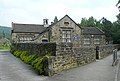
 / 53.18835; -1.61667 (Village school, wall and lavatories)
Rowsley school - geograph.org.uk - 3434249.jpg
1840The school and master's house, now incorporated into the school, is in sandstone with chamfered quoins, and a tile roof with coped gables and moulded kneelers. On the roof is a loured bell turret with a pyramidal roof. The school is in one and two storeys, and has a cruciform plan. The windows are mullioned or mullioned and transomed, and there is a doorway with a Tudor arch. An attached wall links to a lavatory block, later used for other purposes, that has a Welsh slate roof, a louvred ventilator, and four doorways divided by brick piers. [15] [16] II
Drinking fountain
53°11′20″N1°37′07″W / 53.18896°N 1.61858°W / 53.18896; -1.61858 (Drinking fountain)
1841The drinking fountain consists of a half-domed alcove enclosed by a round-headed arch with a vermiculated and rusticated surround. Inside the alcove is a moulded oval trough and a cast iron lion's head for the tap, and over the head of the arch is a crown. [2] [17] II
Rowsley Old Station
53°11′26″N1°36′51″W / 53.19054°N 1.61414°W / 53.19054; -1.61414 (Rowsley Old Station)
Rowsley Railway Station.jpg
1849The station was designed by Joseph Paxton for the Manchester, Buxton, Matlock and Midland Junction Railway in Italianate style. It is in stone and has a slate roof and deep bracketed eaves. There is a single storey, and it contains four semicircular-headed windows, one blocked, and two doorways with segmental fanlights. [15] [18] II
1 and 2 Midland Cottages
53°11′20″N1°36′48″W / 53.18899°N 1.61325°W / 53.18899; -1.61325 (1 and 2 Midland Cottages)
1850A pair of cottages designed by Joseph Paxton for the Midland Railway in Italianate style. They are in stone with a slate roof, two storeys and four bays. At the rear is an outshut with a hipped roof. The windows are sashes with sills on corbels, those in the ground floor with arched heads on impost blocks. In each gable end is a porch with a flat hood on carved brackets with pendentives. [19] II
Lychgate and steps,
St Katherine's Church
53°11′28″N1°37′14″W / 53.19102°N 1.62064°W / 53.19102; -1.62064 (Lychgate and steps, St Katherine's Church)
Lychgate, Rowsley.jpg
Mid 19th centuryThe base of the lychgate consists of two parallel sandstone walls with vermiculation and chamfered coping. The superstructure is in timber, with a hipped tile roof, and the gates are wooden. Leading up to the lychgate is a broad flight of seven stone steps flanked by curved stone walls with chamfered copings and end piers, and then a further five steps. [20] II
Railway viaduct, embankment and overbridge
53°11′25″N1°37′06″W / 53.19031°N 1.61846°W
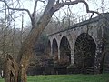
 / 53.19031; -1.61846 (Railway viaduct, embankment and overbridge)
Old railway viaduct over the River Derwent (geograph 3290713).jpg
1851–52The viaduct, embankment and bridge were built to carry the Rowsley to Buxton extension of the Midland Railway over the River Derwent, and are in gritstone. The viaduct is slightly curved, and consists of four semicircular arches on rectangular piers rising from rounded cutwaters. At the top is a shallow parapet with railings over a band. On the north side at each end are abutments with raking buttresses. To the west is an embankment faced with masonry, containing a narrow stilted round-headed archway over a track. [21] II
St Katherine's Church
53°11′28″N1°37′12″W / 53.19123°N 1.61998°W / 53.19123; -1.61998 (St Katherine's Church)
St Katherine's Parish Church, Rowsley - geograph.org.uk - 2947649.jpg
1853–55The north aisle and chapel were added in 1859. The church is in Norman style, and is built in sandstone with a tile roof. It consists of a nave, a north aisle and chapel, a south porch, and a chancel with a vestry and an organ chamber. At the west end is a buttress corbelled out to carry a double bellcote with a colonnette. The south porch is gabled, it has a round-arched entrance with a moulded surround and colonnettes, and above it is a stepped triplet of blind round arches. [15] [22] II
Lamp standard
53°11′20″N1°37′04″W / 53.18900°N 1.61789°W / 53.18900; -1.61789 (Lamp standard)
The Peacock - geograph.org.uk - 2590477.jpg
1867The lamp standard, in the middle of a road junction, is in sandstone. It has a square base, with a curved top and an inscription, on which is a tapering shaft with chamfered angles, about 6 feet (1.8 m) high. There is an inscribed metal plaque on the east side, and on the top is a cast iron lamp with scrolled sides. [23] II
Caudwells Mill
53°11′18″N1°37′08″W / 53.18822°N 1.61876°W / 53.18822; -1.61876 (Caudwells Mill)
Caudwell's Mill Geograph-2855373-by-Ashley-Dace.jpg
1874–75A water-powered flour mill built over a mill race, later a museum, is in sandstone with a Welsh slate roof. There are three storeys, a front of seven bays, and twin semicircular arches over the mill race. The windows have iron frames. On the north gable end is a projecting enclosed hoist, and a large timber and corrugated iron canopy. At the south gable end is a lower gabled bay. [2] [24] II*
War Memorial
53°11′27″N1°37′13″W / 53.19096°N 1.62019°W / 53.19096; -1.62019 (War Memorial)
War Memorial, Rowsley.jpg
c. 1920The war memorial in the churchyard of St Katherine's Church is in sandstone, and in the form of a Saxon cross. There is a rectangular base of two steps, on which is a tall tapering plinth, and a tall cross, with interlace and other decoration on the north face. On the plinth are inscriptions relating to the two World Wars. [25] II

Related Research Articles

<span class="mw-page-title-main">Rowsley</span> Human settlement in England

Rowsley is a village on the A6 road in the English county of Derbyshire. The population as at the 2011 census was 507.

Ashford-in-the-Water is a civil parish in the Derbyshire Dales district of Derbyshire, England. The parish contains 62 listed buildings that are recorded in the National Heritage List for England. Of these, two are listed at Grade II*, the middle of the three grades, and the others are at Grade II, the lowest grade. The parish contains the village of Ashford-in-the-Water and the surrounding countryside, which includes two country houses, Ashford Hall and Thornbridge Hall. These are both listed, together with associated structures and items in their grounds. The River Wye passes through the parish, and four bridges crossing it are listed. Most of the other listed buildings are houses, cottages and associated structures, and the others include a church, a churchyard cross, a former watermill, two public houses, a farmhouse, farm buildings, a vicarage, a well, a dovecote, and a milepost.

Bakewell is a civil parish in the Derbyshire Dales district of Derbyshire, England. The parish contains over 180 listed buildings that are recorded in the National Heritage List for England. Of these, six are listed at Grade I, the highest of the three grades, three are at Grade II*, the middle grade, and the others are at Grade II, the lowest grade. The parish contains the market town of Bakewell and the surrounding area. Most of the listed buildings are houses, cottages and associated structures, shops, offices, banks, and civic buildings. The other listed buildings include churches, two medieval cross bases in a churchyard, bridges, former almshouses, a guide stone, a milestone, former corn mills, public houses, a stile, a sheepwash enclosure, a former workhouse, now a hospital, with associated buildings, a railway station, a drinking fountain, a war memorial, and two telephone kiosks.

Ballidon is a civil parish in the Derbyshire Dales district of Derbyshire, England. The parish contains 15 listed buildings that are recorded in the National Heritage List for England. All the listed buildings are designated at Grade II, the lowest of the three grades, which is applied to "buildings of national importance and special interest". The parish contains the villages of Ballidon and Pikehall, and Ballidon Quarry, and is otherwise entirely rural. Most of the listed buildings are farmhouses and farm buildings, two of which has been converted for other uses by the quarry. The other listed buildings are a church, a milestone, a lime kiln, and an embankment and bridge, originally carrying a railway, and later part of the High Peak Trail.

Baslow and Bubnell is a civil parish in the Derbyshire Dales district of Derbyshire, England. The parish contains 30 listed buildings that are recorded in the National Heritage List for England. Of these, one is listed at Grade I, the highest of the three grades, one is at Grade II*, the middle grade, and the others are at Grade II, the lowest grade. The parish contains the villages of Baslow and Bubnell, and the surrounding countryside and moorland. Most of the listed buildings are houses, cottages and associated structures. The other listed buildings include a church and items in the churchyard, bridges, including a clapper bridge, a hotel, guide posts and guide stones, mile posts and a milestone, a boundary stone, a monument, and a telephone kiosk.

Charlesworth is a civil parish in the High Peak district of Derbyshire, England. The parish contains 15 listed buildings that are recorded in the National Heritage List for England. All the listed buildings are designated at Grade II, the lowest of the three grades, which is applied to "buildings of national importance and special interest". The parish contains the village of Charlesworth and the surrounding countryside. Most of the listed buildings are houses and cottages, farmhouses and farm buildings. The other listed buildings are a bridge, a church, a chapel and its associated walls, and a war memorial.

Clifton and Compton is a civil parish in the Derbyshire Dales district of Derbyshire, England. The parish contains eight listed buildings that are recorded in the National Heritage List for England. Of these, one is listed at Grade II*, the middle of the three grades, and the others are at Grade II, the lowest grade. The parish contains the villages of Clifton and Hangingbridge, and the surrounding area. The listed buildings consist of houses, cottages and associated structures, a church, its lychgate and wall, a road bridge, and a public house.

Crich is a civil parish in the Amber Valley district of Derbyshire, England. The parish contains 52 listed buildings that are recorded in the National Heritage List for England. Of these, one is listed at Grade I, the highest of the three grades, one is at Grade II*, the middle grade, and the others are at Grade II, the lowest grade. The parish contains the villages of Crich, Fritchley, Whatstandwell, and Wheatcroft, and the surrounding countryside. Most of the listed buildings are houses, cottages and associated structures, farmhouses and farm buildings. In the parish is the National Tramway Museum, and a number of structures that have been moved from other sites to the museum are listed. The other listed buildings include churches and chapels, a bridge over the Cromford Canal and a road bridge over the River Derwent, public houses, buildings associated with tramways, a milepost, a village cross, a memorial tower, and a village telephone kiosk.

Ilkeston is a town and unparished area in the Borough of Erewash in Derbyshire, England. The town and surrounding area contain 29 listed buildings that are recorded in the National Heritage List for England. Of these, one is listed at Grade I, the highest of the three grades, three are at Grade II*, the middle grade, and the others are at Grade II, the lowest grade. The Erewash Canal passes through the area, and the listed buildings associated with it are two bridges and two locks. The other listed buildings include churches and a chapel, a church tower, houses, a museum, the town hall, two factories, a drinking fountain, a brick kiln, a library, cemetery buildings, two cinemas, a school, a railway viaduct, and two war memorials.

Hathersage is a civil parish in the Derbyshire Dales district of Derbyshire, England. The parish contains 54 listed buildings that are recorded in the National Heritage List for England. Of these, one is listed at Grade I, the highest of the three grades, three are at Grade II*, the middle grade, and the others are at Grade II, the lowest grade. The parish, which is almost entirely rural, contains the village of Hathersage and the surrounding countryside. Most of the listed buildings are farmhouses and farm buildings, houses, cottages, and associated structures. The other listed buildings include two churches, a cross shaft in a churchyard, a presbytery and a vicarage, two bridges, former mills, a milepost, a former toll house, a railway viaduct, and a lamp column.

Buxton is a spa town in the High Peak district of Derbyshire, England. The town contains 93 listed buildings that are recorded in the National Heritage List for England. Of these, one is listed at Grade I, the highest of the three grades, seven are at Grade II*, the middle grade, and the others are at Grade II, the lowest grade. That the town was a source of natural water springs has been known at least since Roman times, and during the medieval period, St Ann's Well was a shrine and a place of pilgrimage. Buxton developed into a spa town during the 18th and 19th centuries, largely under the influence of the Dukes of Devonshire. The water was considered to have curative powers, and this led to the building of bath houses and later a hospital. Later, leisure facilities grew, and were served by the Pavilion Gardens, and the building of a conservatory, a theatre, a concert hall, and an opera house.

Nether Haddon is a civil parish in the Derbyshire Dales district of Derbyshire, England. The parish contains 15 listed buildings that are recorded in the National Heritage List for England. Of these, one is listed at Grade I, the highest of the three grades, one is at Grade II*, the middle grade, and the others are at Grade II, the lowest grade. The most important building in the parish is Haddon Hall, which is listed together with associated structures in the gardens and grounds. The River Wye and its tributary, River Lathkill, flow through the parish, and bridges crossing them are listed. The other listed buildings are a farmhouse and associated structures, a barn converted for residential use, and a milestone.

Newton Solney is a civil parish in the South Derbyshire district of Derbyshire, England. The parish contains 19 listed buildings that are recorded in the National Heritage List for England. Of these, two are listed at Grade II*, the middle of the three grades, and the others are at Grade II, the lowest grade. The parish contains the village of Newton Solney and the surrounding area. Most of the listed buildings are houses, cottages and associated structures, farmhouses and farm buildings. The other listed buildings include a church, follies, a hotel and a public house, a row of almshouses, and part of a model farm.

Norbury and Roston is a civil parish in the Derbyshire Dales district of Derbyshire, England. The parish contains nine listed buildings that are recorded in the National Heritage List for England. Of these, two are listed at Grade I, the highest of the three grades, and the others are at Grade II, the lowest grade. The parish contains the village of Norbury, the hamlet of Roston, and the surrounding countryside. The listed buildings consist of a church and graves in the churchyard, a medieval hall house and an attached 17th-century country house, a former water mill and a drying kiln, a smaller house, and two bridges.

Ripley is a civil parish in the Amber Valley district of Derbyshire, England. The parish contains 62 listed buildings that are recorded in the National Heritage List for England. Of these, five are listed at Grade II*, the middle of the three grades, and the others are at Grade II, the lowest grade. The parish contains the town of Ripley, smaller settlements including Ambergate, Bullbridge, Butterley, Fritchley, Heage, Nether Heage and Waingroves, and the surrounding countryside. The Cromford Canal, now partly closed, runs through the parish, and the listed buildings associated with it are bridges and an embankment. Also running through the parish is a railway that originated as the North Midland Railway with a later branch, the Manchester, Buxton, Matlock and Midland Junction Railway, and associated with these are bridges, viaducts, a goods shed, and the portals of a tunnel. Most of the other listed buildings are houses, cottages and associated structures, farmhouses and farm buildings. The other listed buildings include churches, a windmill, a pair of coke iron furnaces, factory buildings, public houses, mileposts, colliery buildings, a railway station and signal box at Butterley, and a war memorial.

Risley is a civil parish in the Borough of Erewash in Derbyshire, England. The parish contains 17 listed buildings that are recorded in the National Heritage List for England. Of these, five are listed at Grade II*, the middle of the three grades, and the others are at Grade II, the lowest grade. The parish contains the village of Risley and the surrounding area. The listed buildings include a country house and structures in its grounds, a church and items in the churchyard, smaller houses, buildings associated with a school, a farmhouse and barn, and two mileposts.

South Wingfield is a civil parish in the Amber Valley district of Derbyshire, England. The parish contains 40 listed buildings that are recorded in the National Heritage List for England. Of these, one is listed at Grade I, the highest of the three grades, two are at Grade II*, the middle grade, and the others are at Grade II, the lowest grade. The parish contains the villages of South Wingfield and Oakerthorpe and the surrounding countryside. A railway built by the North Midland Railway runs through the parish, and the listed buildings associated with it are bridges, tunnel portals, and a station and associated structures. The other listed buildings include a ruined manor house, smaller houses, cottages and associated structures, farmhouses and farm buildings, a church, road bridges, public houses, and a former windmill.

Stanton by Bridge is a civil parish in the South Derbyshire district of Derbyshire, England. The parish contains twelve listed buildings that are recorded in the National Heritage List for England. Of these, two are listed at Grade I, the highest of the three grades, and the others are at Grade II, the lowest grade. The parish contains the village of Stanton by Bridge and the surrounding area. The listed buildings consist of a church, a bridge and causeway, houses and associated structures, farmhouses and a farm building.

Twyford and Stenson is a civil parish in the South Derbyshire district of Derbyshire, England. The parish contains twelve listed buildings that are recorded in the National Heritage List for England. Of these, one is listed at Grade I, the highest of the three grades, one is at Grade II*, the middle grade, and the others are at Grade II, the lowest grade. The parish contains the villages of Twyford and Stenson and the surrounding countryside. The Trent and Mersey Canal runs through the north of the parish, and the listed buildings associated with it are bridges, a lock and a cottage. The other listed buildings are a church, houses, cottages and associated structures, and farmhouses and farm buildings.

Whaley Bridge is a civil parish in the High Peak district of Derbyshire, England. The parish contains 27 listed buildings that are recorded in the National Heritage List for England. Of these, two are listed at Grade II*, the middle of the three grades, and the others are at Grade II, the lowest grade. The parish contains the town of Whaley Bridge and the surrounding area. The Peak Forest Canal passes through the parish, and the listed buildings associated with it are an aqueduct, a horse tunnel, and a transhipment warehouse. Most of the other listed buildings are houses, cottages and associated structures, farmhouses and farm buildings. The rest of the listed buildings include churches and a chapel, a hotel and a public house, a road bridge, a milestone, a colliery air shaft tower, and a railway bridge.

References

Citations

Sources