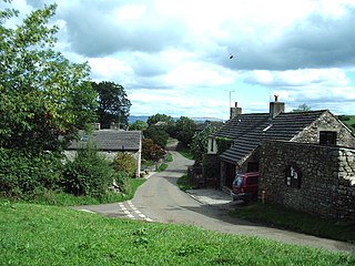
Gosforth is a civil parish in the Borough of Copeland, Cumbria, England. It contains 19 buildings that are recorded in the National Heritage List for England. Of these, one is listed at Grade I, the highest of the three grades, three are at Grade II*, the middle grade, and the others are at Grade II, the lowest grade. The parish contains the village of Gosforth and the surrounding countryside. The listed buildings include houses and associated structures, farmhouses, farm buildings, a church and structures in the churchyard, a boundary stone, and a milestone.
Wasdale is a civil parish in the Borough of Copeland, Cumbria, England. It contains eight listed buildings that are recorded in the National Heritage List for England. Of these, one is listed at Grade II*, the middle of the three grades, and the others are at Grade II, the lowest grade. The parish is in the Lake District National Park. It contains the village of Nether Wasdale and the community of Wasdale Head, together with the countryside, moorland and mountains surrounding Wastwater. The listed buildings comprise two churches, two farmhouses and associated buildings, two bridges, a boundary stone, and a maypole.
Colby is a civil parish in the Eden District, Cumbria, England. It contains three buildings that are recorded in the National Heritage List for England. Of these, one is listed at Grade II*, the middle of the three grades, and the others are at Grade II, the lowest grade. The parish contains the village of Colby and the surrounding countryside, and the listed buildings consist of farmhouses and farm buildings.
Crosby Garrett is a civil parish in the Eden District, Cumbria, England. It contains 13 buildings that are recorded in the National Heritage List for England. Of these, one is listed at Grade I, the highest of the three grades, two are at Grade II*, the middle grade, and the others are at Grade II, the lowest grade. The parish contains the village of Crosby Garrett and the surrounding countryside. The listed buildings consists of a church, houses and associated structures, farmhouses, farm buildings, two railway viaducts, a pair of limekilns, and a boundary stone.
Culgaith is a civil parish in the Eden District, Cumbria, England. It contains 23 buildings that are recorded in the National Heritage List for England. Of these, two are listed at Grade II*, the middle of the three grades, and the others are at Grade II, the lowest grade. The parish contains the villages of Culgaith, Skirwith, and Kirkland and is otherwise rural. The listed buildings consist of houses and associated structures, farmhouses, farm buildings, churches and items in the churchyards, a chapel, a war memorial, and three boundary stones.
Lazonby is a civil parish in the Eden District, Cumbria, England. It contains eleven listed buildings that are recorded in the National Heritage List for England. All the listed buildings are designated at Grade II, the lowest of the three grades, which is applied to "buildings of national importance and special interest". The parish contains the village of Lazonby and the surrounding countryside. The listed buildings comprise houses, farmhouses and farm buildings, a church, a bridge, a boundary stone, a school, a railway viaduct, and a drinking trough for horses.
Martindale is a civil parish in the Eden District, Cumbria, England. It contains eleven listed buildings that are recorded in the National Heritage List for England. Of these, one is listed at Grade II*, the middle of the three grades, and the others are at Grade II, the lowest grade. The parish is in the Lake District National Park, and is sparsely populated, the only centres of habitation being the hamlets of Howtown and Sandwick; most of the parish consists of countryside, moorland and fells. The listed buildings comprise houses and associated structures, farmhouses, farm buildings, two churches and a monument in a churchyard, and two bridges.
Mungrisdale is a civil parish in the Eden District, Cumbria, England. It contains 46 listed buildings that are recorded in the National Heritage List for England. Of these, three are listed at Grade II*, the middle of the three grades, and the others are at Grade II, the lowest grade. The parish is in the Lake District National Park, and is sparsely populated, consisting mainly of countryside, moorland and fells. There are small settlements at Mungrisdale, Mosedale, Haltcliff Bridge, Southerfell, Berrier, Hutton Moor End, Hutton Roof, Low Mill, and Swineside. Most of the listed buildings are houses, farmhouses and farm buildings, the other listed buildings including a Friends' meeting house, bridges, a church, a former saw mill, a former school, seven boundary stones, and a telephone kiosk.
Winton is a civil parish in the Eden District, Cumbria, England. It contains twelve listed buildings that are recorded in the National Heritage List for England. Of these, one is listed at Grade II*, the middle of the three grades, and the others are at Grade II, the lowest grade. The parish includes the village of Winton, and is otherwise rural. The listed buildings consist of houses and associated structures, farmhouses and farm buildings, and a pinfold, a boundary stone, and a former school.
Barbon is a civil parish in the South Lakeland District of Cumbria, England. It contains 23 listed buildings that are recorded in the National Heritage List for England. Of these, two are listed at Grade II*, the middle of the three grades, and the others are at Grade II, the lowest grade. The parish contains the village of Barbon and the surrounding countryside. The listed buildings consist of houses, farmhouses and farm buildings, bridges, a milestone, a boundary stone, and a church.
Beetham is a civil parish in the South Lakeland District of Cumbria, England. It contains 47 listed buildings that are recorded in the National Heritage List for England. Of these, two are listed at Grade I, the highest of the three grades, four are at Grade II*, the middle grade, and the others are at Grade II, the lowest grade. The parish contains the villages of Beetham, Farleton and Hazelslack, and the surrounding countryside. The Lancaster Canal passes through the parish, and the listed buildings associated with this are bridges, an aqueduct and a milestone. Most of the listed buildings in the parish are houses, some of them originally tower houses, and associated structures, farmhouses and farm buildings. The other listed buildings consist of a church, bridges, a former corn mill, milestones and a milepost, boundary stones and a boundary post, a former school, a signal box, and a war memorial.
Coniston is a civil parish in the South Lakeland District of Cumbria, England. It contains 53 listed buildings that are recorded in the National Heritage List for England. Of these, four are listed at Grade II*, the middle of the three grades, and the others are at Grade II, the lowest grade. The parish is in the Lake District National Park and is located to the west, north and east of Coniston Water. Most of the listed buildings are houses and associated structures, farmhouses and farm buildings. The other listed buildings include bridges, a limekiln, a folly, a boundary stone, a church, a drinking fountain, and a memorial.
Heversham is a civil parish in the South Lakeland District of Cumbria, England. It contains 23 listed buildings that are recorded in the National Heritage List for England. Of these, three are listed at Grade II*, the middle of the three grades, and the others are at Grade II, the lowest grade. The parish contains the village of Heversham and the surrounding countryside. The listed buildings include houses, farmhouses, farm buildings, a church and associated structures, a former school, boundary stones, and a war memorial.
Holme is a civil parish in the South Lakeland District of Cumbria, England. It contains 14 listed buildings that are recorded in the National Heritage List for England. All the listed buildings are designated at Grade II, the lowest of the three grades, which is applied to "buildings of national importance and special interest". The parish contains the village of Holme and the surrounding countryside. The Lancaster Canal passes through the parish, and nine structures on the canal are listed, eight bridges and a milepost. The other listed buildings are a house, a farmhouse, two boundary stones, and a milepost on a road.
Kentmere is a civil parish in the South Lakeland District of Cumbria, England. It contains 14 listed buildings that are recorded in the National Heritage List for England. Of these, one is listed at Grade II*, the middle of the three grades, and the others are at Grade II, the lowest grade. The parish is in the Lake District National Park and is almost completely rural, the only significant settlement being the village of Kentmere. Almost all the listed buildings are farmhouses and farm buildings, the others being a tower house a church, and a limekiln.
Levens is a civil parish in the South Lakeland District of Cumbria, England. It contains 21 listed buildings that are recorded in the National Heritage List for England. Of these, one is listed at Grade I, the highest of the three grades, two are at Grade II*, the middle grade, and the others are at Grade II, the lowest grade. The parish contains the village of Levens and the surrounding countryside. The major building in the parish is Levens Hall; this and associated structures are listed. The other listed buildings include houses, farmhouses, farm buildings, a bridge, a church, and a limekiln.
Lupton is a civil parish in the South Lakeland District of Cumbria, England. It contains 13 listed buildings that are recorded in the National Heritage List for England. All the listed buildings are designated at Grade II, the lowest of the three grades, which is applied to "buildings of national importance and special interest". The parish is almost completely rural, without any major settlement. The listed buildings consist of houses, farmhouses, farm buildings, a church, a bridge, milestones, and a boundary stone.
Natland is a civil parish in the South Lakeland District of Cumbria, England. It contains 14 listed buildings that are recorded in the National Heritage List for England. Of these, one is listed at Grade II*, the middle of the three grades, and the others are at Grade II, the lowest grade. The parish contains the village of Natland, and is otherwise rural. The listed buildings include houses, farmhouses, farm buildings, bridges, a church, a milestone, and a boundary post.
Strickland Roger is a civil parish in the South Lakeland District of Cumbria, England. It contains nine listed buildings that are recorded in the National Heritage List for England. Of these, one is listed at Grade II*, the middle of the three grades, and the others are at Grade II, the lowest grade. The parish is almost completely rural, and the listed buildings consist of houses, a gatehouse, farmhouses and farm buildings, a bridge, and a cottage associated with a mill.