Fourteen buildings and other structures in the English civil parish of Wrenbury cum Frith have been officially designated as listed buildings for their "special architectural and historic interest".[1] Three of the listed buildings are classified as being in gradeII* and the remainder in gradeII; the parish has no grade-I-listed buildings.
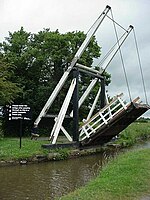
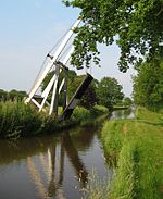
Wrenbury cum Frith is in the Cheshire East division of the ceremonial county of Cheshire, situated on the Cheshire Plain. The River Weaver and the Llangollen Canal both cross the civil parish. Before the railway network reached the area, the canal was important for the transport of locally produced cheese and other dairy products from this dairy farming region to Chester, North Wales and the Midlands.[2] Three timber canal lift bridges of the drawbridge type were constructed by Thomas Telford, probably in the 1790s, after his appointment as engineer to what was then known as the Ellesmere Canal.[3] Two of the lift bridges are footbridges serving farms, which are still operated manually using the original counterweight system; they are listed at grade II*. The third, believed to be one of only two lift bridges of this type in the country to carry road traffic,[4] has had a mechanical crank fitted. A fourth sandstone road bridge crosses the Weaver. A lock on the canal is also listed.
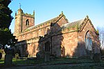
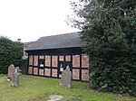
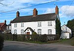
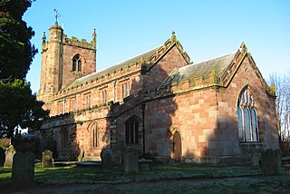
The village of Wrenbury is the only substantial settlement in the civil parish. Many of the listed buildings and structures in the civil parish are located within the conservation area that protects much of its centre and spreads north-west to beyond the canal.[5] Five cluster around the village green and the adjacent parish church dedicated to St Margaret, the third grade-II*-listed structure. The church dates from the early 16th century and is the oldest listed structure in the civil parish. The four half-timbered "black and white" cottages to have listed status all date from the 17th century; this century accounts for half of the timber-framed buildings in Cheshire.[6] The earliest are believed to be Elm House on the village green and a small cottage within the churchyard, thought to be a former almshouse and a schoolmaster's house associated with the free school founded in 1605, also located in the churchyard.[7][8] Later listed buildings are built in brick, a reflection of the shift in domestic architecture from timber framing to brick construction, also observed in unlisted buildings. The most recent listed building is the village primary school of 1879, which is typical of the local schools built after the Education Act of 1870.[9]
Wrenbury Church Bridge (no. 19) is a single-span timber lift bridge by Thomas Telford. It is an accommodation bridge and also serves a public footpath. The bridge is lifted manually via a counterbalancing weight fixed to paired beams parallel to the bridge platform and attached to its free end with chains. Vertical beams support the structure, and the timberwork is strengthened with iron rods. Guards were installed in 1889.[12][13]
Wrenbury Frith Bridge (no. 21) is a single-span timber lift bridge by Thomas Telford. It is an accommodation bridge with no public right of way. The bridge is lifted manually via a counterbalancing weight fixed to paired beams parallel to the bridge platform and attached to its free end with chains. Vertical beams support the structure, and the timberwork is strengthened with iron rods. The bridge has no guard rails.[14]
This canal lock, the first in a series of three, lies on the boundary with Baddiley. It was built by J. Fletcher for Thomas Telford in blue-and-red brick with stone dressings. The lower lock gates are double wooden mitre gates, replaced in 2011; the single upper gate is a metal replacement.[15][16][17]
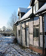
Sometimes known as Churchyard Cottage, this small single-storey building is possibly a former almshouse and schoolmaster's house. It has a timber frame featuring small framing with brick infill. The asbestos tile roof replaces the original thatch. In 1997, it was restored for use as a holiday cottage.[7][8][18]
Elm House is a large two-storey half-timbered cottage with a slate roof and a prominent brick chimney, placed asymmetrically. The timber frame features small framing with angle braces and has rendered brick infill. Restoration in the 1990s incorporated brick outbuildings to form an L-shape. The building was formerly used as a grocer's shop and is now a private dwelling.[7][19]
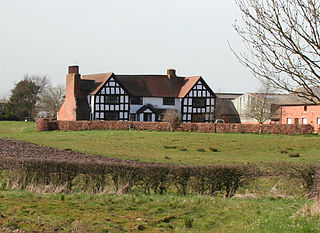
The Grange, formerly known as Smeaton Grange, is a half-timbered, two-storey farmhouse under a tiled roof. The timber frame features small framing which has been infilled with brick. The main face has a protruding gabled wing with a jettied first floor. A prominent brick chimney is placed asymmetrically.[20][21]
Hawk House is a whitewashed brick cottage of two storeys and four bays under a tiled roof, with three symmetrically placed brick chimneys. A central porch and a wing to the rear were added in the 19th century. Now a private dwelling, the building was once an inn, called the Hawk and later the Hawk and Buckle, and was also used as a butcher's shop.[22][23]
Pinsley Green Cottages are a pair of terraced cottages, now a single house, with a tiled roof replacing the original thatch. The older northern cottage has a timber frame, featuring small framing with a middle rail and passing braces. The southern cottage dates from the mid 18th century and is built of rendered brick. There is a 20th-century extension to the rear.[24]
Railings, gates and gatepiers to churchyard of St Margaret
These cast-iron railings and gates to the churchyard have a central double gate flanked with paired wicket gates. The four gatepiers have latticed sides and are topped with finials shaped like pinecones. The palings of the railings have arrowhead tops.[25]
Wrenbury School is an L-shaped single-storey primary school in red brick with blue-brick diapering and stone dressings. A wing protrudes on the left of the front face, with decorative timberwork to the gable and a triple arched window; the two large gables to the front face have similar timberwork and windows. A square bellcote stands in the angle of the L; it becomes circular above roof level and is topped with a weather vane. The adjacent chimney breast bears a circular stone date plaque. The building was extended in 1987.[9][26]
Starkey Farmhouse, also known as Gillys Farm and currently Tudor Rose Farm, is a two-storey half-timbered former farmhouse with a shingle roof, which replaces the original thatch. The timber frame features small framing with angle braces, and has rendered brick infill. One gable is slightly jettied. A central wing at the rear dates from later in the 17th century and is also half-timbered; it has been further extended in the 20th century. The interior has paintings on either side of the fireplace, believed to date from before the Reformation and to show Saint Peter and Simon the Zealot.[27][28]
Wrenbury Bridge (no. 20) is a single-span timber lift bridge by Thomas Telford, which carries Cholmondeley Road. A mechanical crank was fitted in the 20th century to operate the bridge. It was formerly lifted manually via a counterbalancing weight fixed to paired beams parallel to the bridge platform and attached to its free end with chains. Vertical beams support the structure, and the timberwork is strengthened with iron rods.[29]
Baddiley is a scattered settlement and civil parish in the unitary authority of Cheshire East and the ceremonial county of Cheshire, England. The civil parish also includes the north-western part of the village of Ravensmoor, as well as the small settlements of Baddiley Hulse, Batterley Hill, and parts of Gradeley Green and Swanley. According to the 2001 Census the parish had a total population of 226, increasing at the 2011 Census to 249.
Broomhall is a civil parish in the unitary authority of Cheshire East and the ceremonial county of Cheshire, England. The main line of the Shropshire Union Canal runs through the parish and the River Weaver forms part of its boundary. The main settlement is the hamlet of Broomhall Green, which lies on the A530 about 3.5 miles (5.6 km) south-west of Nantwich. The civil parish has an area of 539 hectares, and also includes part of the small settlement of Sandford, with a total population of around 200 in 2011. Nearby villages include Aston, Sound, Wrenbury and Audlem. Broomhall appears in the Domesday survey and the name was also historically spelled Bromhall.
Burland is a village and former civil parish, now in the parish of Burland and Acton, in the unitary authority area of Cheshire East and the ceremonial county of Cheshire, England, about 2+1⁄2 miles west of Nantwich. The civil parish also included the small settlements of Burland Lower Green, Burland Upper Green, Hollin Green and Stoneley Green, as well as parts of Gradeley Green and Swanley. The eastern part of the village of Ravensmoor also falls within the civil parish.
Marbury is a small village located at SJ560457 in the civil parish of Marbury and District, formerly Marbury cum Quoisley, within the unitary authority of Cheshire East and the ceremonial county of Cheshire, England. It is administered jointly with the adjacent civil parishes of Norbury and Wirswall. The village lies around 3 miles (5 km) north east of Whitchurch in Shropshire and 7 miles (11 km) south west of Nantwich in Cheshire. Nearby villages include Malpas, No Man's Heath, Norbury, Wirswall and Wrenbury. The civil parish bordered Shropshire and covers 2,168 acres (877 ha); it also contains the small settlements of Hollins Lane, Marley Green and Quoisley, as well as parts of Hollyhurst and Willeymoor. The total population was just under 250 in 2001, and – combined with Wirswall – 352 in 2011.
Wrenbury-cum-Frith is a village and civil parish in the unitary authority of Cheshire East, and the ceremonial county of Cheshire, England. It lies on the River Weaver, around 8.5 miles south-west of Crewe.
Wirswall is a village and former civil parish, now in the parish of Marbury and District, in the unitary authority area of Cheshire East and the ceremonial county of Cheshire, England, located at SJ544441 near the Shropshire border, around 1½ miles north of Whitchurch. The historical township had an area of 973 acres (3.94 km2). The civil parish also included the settlements of Bradeley Green, Wicksted and part of Willey Moor.
Norbury is a hamlet and former civil parish, now in the parish of Marbury and District, in the Cheshire East district, in the ceremonial county of Cheshire, England. It included the small settlements of Gauntons Bank, Hurst Green, Swanwick Green, Norbury Common and Holtridge, with a total population of 194 people in 2011. The hamlet of Norbury lies around 5 miles (8 km) north of Whitchurch, Shropshire. Nearby villages include No Man's Heath, Marbury and Wrenbury.
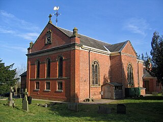
St Michael's Church is in the civil parish of Baddiley, Cheshire, England. It is recorded in the National Heritage List for England as a designated Grade I listed building. The church lies at the end of a lane near to Baddiley Hall, formerly the home of the Mainwaring family. It dates from the early 14th century. The nave and chancel are divided by a pre-Reformation screen and tympanum. The church is one of a 'handful' of timber-framed churches remaining in the country. It continues to be an active Anglican parish church in the diocese of Chester, the archdeaconry of Macclesfield and the deanery of Nantwich. Its benefice is combined with those of St Mary's and St Michael's Church, Burleydam and St Margaret's Church, Wrenbury.
Dodcott cum Wilkesley is a civil parish in the unitary authority of Cheshire East and the ceremonial county of Cheshire, England. The hamlet of Wilkesley lies 2+1⁄2 miles to the west of Audlem and 7 miles to the south west of Nantwich. The parish also includes the village of Burleydam, the largest settlement, as well as the small settlements of Butterley Heyes, Cheshire Fields, Combermere, Lightwood Green and Royal's Green. It also formerly contained the settlements of Pinsley Green and Smeaton Wood, now located in Wrenbury cum Frith civil parish. Nearby villages include Adderley and Calverhall in Shropshire and Audlem, Newhall and Wrenbury within Cheshire.
Sound is a hamlet and civil parish in the unitary authority of Cheshire East and the ceremonial county of Cheshire, England. The hamlet is located 3+1⁄4 miles (5.2 km) to the south west of Nantwich. The civil parish covers 1,089 acres (441 ha) and also includes the small settlements of Newtown and Sound Heath, with a total population at the 2011 census of 239. Nearby villages include Aston, Ravensmoor and Wrenbury.
St Michael's Church, also known as St Michael and All Angels, stands on a small rise overlooking Big Mere in the village of Marbury, Cheshire, England. The church is recorded in the National Heritage List for England as a designated Grade II* listed building. It is an active Anglican parish church in the diocese of Chester, the archdeaconry of Chester and the deanery of Malpas. Its benefice is combined with those of St Chad, Tushingham, and St Mary, Whitewell.
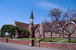
St Margaret's Church overlooks the village green of Wrenbury, Cheshire, England. The church is recorded in the National Heritage List for England as a designated Grade II* listed building. It is an active Anglican parish church in the diocese of Chester, the archdeaconry of Macclesfield and the deanery of Nantwich. Its benefice is combined with those of St Michael's, Baddiley and St Mary's and St Michael's, Burleydam.
St Mary's and St Michael's Church is in the village of Burleydam in the civil parish of Dodcott cum Wilkesley, Cheshire, England. The church is some 1.5 miles (2 km) to the southeast of Combermere Abbey. It is recorded in the National Heritage List for England as a designated Grade II listed building. It is an active Anglican parish church in the diocese of Chester, the archdeaconry of Macclesfield and the deanery of Nantwich. Its benefice is combined with those of St Michael, Baddiley, and St Margaret, Wrenbury.
Swanley is a hamlet at SJ618523 in the unitary authority of Cheshire East and the ceremonial county of Cheshire, England. It mainly falls within the civil parish of Burland, with a part in Baddiley. Swanley lies around 2+1⁄2 miles (4.0 km) to the west of Nantwich and immediately north of the hamlet of Stoneley Green. Nearby villages include Burland, Acton and Ravensmoor. A dry moated site is located near the 16th-century Swanley Hall, and there are two 17th-century buildings. The Llangollen Canal runs through the hamlet, with two locks, two bridges and a marina.
A total of 21 buildings and other structures in the English civil parish of Dodcott cum Wilkesley have been officially designated as listed buildings for their "special architectural and historic interest". Dodcott cum Wilkesley is in the Cheshire East division of the ceremonial county of Cheshire, situated on the Cheshire Plain at the border with Shropshire. The civil parish is predominantly rural, with many scattered minor settlements, the largest of which is the small village of Burleydam. One of the listed buildings is classified by English Heritage as being in grade I, meaning "of exceptional interest, sometimes considered to be internationally important" ; two are in grade II* and the remainder in grade II.
Waverton is a civil parish in Cheshire West and Chester, England. It contains 17 buildings that are recorded in the National Heritage List for England as designated listed buildings. Of these, one is listed at Grade II*, the middle grade, and the others are at Grade II. Apart from the village of Waverton, the parish is rural. Passing through the parish is the Shropshire Union Canal, and three of the bridges crossing this are listed. The other listed buildings in the parish include the parish church, a sundial in the churchyard and the churchyard walls, a former steam mill, a former railway station and goods shed, a former school, a former institute, and a war memorial, together with houses and cottages.
Baddiley is a civil parish in Cheshire East, England. It contains nine buildings that are recorded in the National Heritage List for England as designated listed buildings. Of these, one is listed at Grade I, the highest grade, and the others are at Grade II. Apart from the village of Baddily, the parish is entirely rural. The listed buildings consist of the village church, houses and farm buildings. The Llangollen Canal runs through the parish, and the three locks on the canal in the parish are also listed.
Chorley, Cholmondeley is a civil parish in Cheshire East, England. It contains four buildings that are recorded in the National Heritage List for England as designated listed buildings, all of which are at Grade II. This grade is the lowest of the three gradings given to listed buildings and is applied to "buildings of national importance and special interest". The parish is entirely rural, the listed buildings consisting of two farmhouses, a cottage, and a former bridewell converted into a house.
Marbury cum Quoisley is a former civil parish in Cheshire East, England. It contained 11 buildings that are recorded in the National Heritage List for England as designated listed buildings. Of these, one is listed at Grade II*, the middle grade, and the others are at Grade II. Apart from the village of Marbury the parish was rural. The major buildings in the parish are St Michael's Church and Marbury Hall; these and some associated buildings are listed. Also listed are some 16th and 17th-century houses and farm buildings that are timber-framed or incorporate timber framing. The parish included the part of the Combermere estate that contains a monumental obelisk that is listed.
Newhall is a civil parish in Cheshire East, England. It contains 14 buildings that are recorded in the National Heritage List for England as designated listed buildings, all of which are at Grade II. This grade is the lowest of the three gradings given to listed buildings and is applied to "buildings of national importance and special interest". The parish contains the village of Aston, but is otherwise almost completely rural, and its listed buildings reflect this, including farmhouses and other houses. The Shropshire Union Canal runs through the parish, and there are two listed buildings associated with this, a bridge and a milepost. Also listed are a boundary stone, a telephone kiosk, and a lychgate.
This page is based on this Wikipedia article Text is available under the CC BY-SA 4.0 license; additional terms may apply. Images, videos and audio are available under their respective licenses.