
Republic Airport is a regional airport in East Farmingdale, New York, located one mile east of Farmingdale village limits.
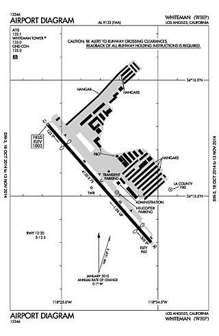
Whiteman Airport is a general aviation airport in the northeastern San Fernando Valley community of Pacoima, in the city of Los Angeles, California, United States.

Central Illinois Regional Airport at Bloomington–Normal is a public airport in McLean County, Illinois, three miles east of Bloomington and southeast of Normal. Owned by the Bloomington–Normal Airport Authority, it is also known as Central Illinois Regional Airport (CIRA).

Chicago Executive Airport, formerly Palwaukee Municipal Airport, is a public airport 18 miles (33 km) northwest of Chicago, in the village of Wheeling in Cook County, Illinois, United States. It is owned by the City of Prospect Heights and the Village of Wheeling.

Cuyahoga County Airport, also known as Robert D. Shea Field, is a public use airport in northeastern Cuyahoga County, Ohio, United States. Owned and operated by Cuyahoga County since 1946, it also serves Lake County and Geauga County. The airport is located 10 nautical miles east of downtown Cleveland and sits on the border of three cities: Highland Heights, Richmond Heights and Willoughby Hills. It is included in the National Plan of Integrated Airport Systems for 2011–2015, which categorized it as a general aviation reliever airport for Cleveland Hopkins International Airport.

Springfield–Beckley Municipal Airport is a civil-military airport five miles (8 km) south of Springfield, in Clark County, Ohio, United States. It is owned by the city of Springfield. It is named after the Beckley family, a member of which knew the Wright Brothers, and witnessed and photographed their first flights.

Montgomery-Gibbs Executive Airport, formerly known as Montgomery Field and Gibbs Field, is a public airport in San Diego, California, United States, six miles (10 km) north of downtown San Diego. The airport covers 456 acres (185 ha) and has three runways, one public and two private helipads. The runways are 28 Right/10 Left-28 Left/10 Right parallels and 05/23.

Toledo Suburban Airport is a public use airport located two nautical miles southwest of the central business district of Lambertville, a city in Monroe County, Michigan, United States. It is located just north of Michigan's border with Ohio and northwest of the city of Toledo, Ohio. It is included in the Federal Aviation Administration (FAA) National Plan of Integrated Airport Systems for 2017–2021, in which it is categorized as a general aviation facility.
Portage County Airport, also known as Portage County Regional Airport, is a public use airport in Portage County, Ohio, United States. It is owned by the Portage County Airport Authority and located three nautical miles (6 km) north of Ravenna, in Shalersville Township. This airport is included in the National Plan of Integrated Airport Systems for 2011–2015, which categorized it as a general aviation facility.

Union County Airport is a public use airport in Union County, Ohio, United States. It is owned by the Union County Airport Authority and located one nautical mile (2 km) southeast of the central business district of Marysville, Ohio. This airport is included in the National Plan of Integrated Airport Systems for 2011–2015, which categorized it as a general aviation facility.
Mesquite Metro Airport is a public use airport in Dallas County, Texas, 3 nautical miles (5.6 km) east of the central business district of Mesquite. The airport is west of the border of Dallas County and Kaufman County.

Canton–Plymouth Mettetal Airport is a public use airport located in Canton Township, Michigan, United States. The airport lies two nautical miles (3.7 km) south of the central business district of Plymouth, in Wayne County. The airport is owned and operated by the Michigan Department of Transportation (MDOT). It is also referred to as Mettetal Airport. The airport is uncontrolled (non-towered), and is used for general aviation purposes.

The 1994 St. Louis Airport collision occurred when TWA Flight 427, operated using a McDonnell Douglas MD-82, struck a Cessna 441 Conquest II during its take-off roll, killing both of its occupants. The incident took place on November 22, 1994, at St. Louis Lambert International Airport (STL) in Bridgeton, Missouri.

Sault Ste. Marie Municipal Airport, also known as Sanderson Field, is a city-owned, public-use airport located one nautical mile (1.85 km) southwest of the central business district of Sault Ste. Marie, a city in Chippewa County, Michigan, United States.
Galion Municipal Airport is three miles northeast of Galion in Crawford County, Ohio. The FAA's National Plan of Integrated Airport Systems for 2009–2013 classified it as a general aviation airport.
Edgar County Airport is a public use airport in Edgar County, Illinois, United States. It is located five nautical miles north of the central business district of Paris, Illinois. The airport is included in the FAA's National Plan of Integrated Airport Systems for 2017–2021, which categorized it as a general aviation facility.

Marion Municipal Airport is three miles northeast of Marion, in Marion County, Ohio. The FAA's National Plan of Integrated Airport Systems for 2011–2015 categorized it as a general aviation facility.
Greenville Municipal Airport is a city-owned, public-use airport located three nautical miles (6 km) south of the central business district of Greenville, a city in Montcalm County, Michigan, United States. It is included in the Federal Aviation Administration (FAA) National Plan of Integrated Airport Systems for 2017–2021, in which it is categorized as a local general aviation facility.
Harry Clever Field is a public airport three miles southeast of New Philadelphia, in Tuscarawas County, Ohio. The National Plan of Integrated Airport Systems for 2018 categorized it as a general aviation facility.
Sparta Community Airport, also known as Hunter Field, is a civil, public use airport 2 miles north of Sparta in Randolph County, Illinois. The airport is publicly owned by the Sparta Community Airport Authority.

