Little Browning, Montana

Last updated
Little Browning, Montana
USA Montana location map.svg
Red pog.svg
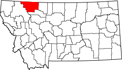
Little Browning
Location of Little Browning, Montana
Usa edcp location map.svg
Red pog.svg
Little Browning
Little Browning (the United States)
Coordinates: 48°37′31″N112°21′0″W / 48.62528°N 112.35000°W / 48.62528; -112.35000 Coordinates: 48°37′31″N112°21′0″W / 48.62528°N 112.35000°W / 48.62528; -112.35000
Country United States
State Montana
County Glacier
Area
[1]
  Total0.75 sq mi (1.94 km2)
  Land0.73 sq mi (1.88 km2)
  Water0.02 sq mi (0.06 km2)
Elevation
3,701 ft (1,128 m)
Population
 (2020)
  Total218
  Density300.28/sq mi (115.93/km2)
Time zone UTC-7 (Mountain (MST))
  Summer (DST) UTC-6 (MDT)
Area code 406
FIPS code 30-43835
GNIS feature ID2583824 [2]

Little Browning is a census-designated place (CDP) in Glacier County, Montana, United States. The population was 206 at the 2010 census. [3]

Demographics

Historical population
CensusPop.
2020 218
U.S. Decennial Census [4]

Related Research Articles

<span class="mw-page-title-main">Montana</span> U.S. state

Montana is a state in the Mountain West subregion of the Western United States. It is bordered by Idaho to the west; North Dakota and South Dakota to the east; Wyoming to the south; and by the Canadian provinces of Alberta, British Columbia, and Saskatchewan to the north. It is the fourth-largest state by area, the eighth-least populous state, and the third-least densely populated state. Its state capital is Helena. The western half of Montana contains numerous mountain ranges, while the eastern half is characterized by western prairie terrain and badlands, with smaller mountain ranges found throughout the state. In all, 77 named ranges are part of the Rocky Mountains.

<span class="mw-page-title-main">Richland County, Montana</span> County in Montana, United States

Richland County is a county in the U.S. state of Montana. As of the 2020 census, the population was 11,491. Its county seat is Sidney.

<span class="mw-page-title-main">Madison County, Montana</span> County in Montana, United States

Madison County is a county in the U.S. state of Montana. As of the 2020 census, the population was 8,623. Its county seat is Virginia City. The county was founded in 1865; at the time it was part of the Montana Territory.

<span class="mw-page-title-main">Glacier County, Montana</span> County in Montana, United States

Glacier County is located in the U.S. state of Montana. As of the 2020 census, the population was 13,778. The county is located in northwestern Montana between the Great Plains and the Rocky Mountains, known to the Blackfeet as the "Backbone of the World". The county is geographically and culturally diverse and includes the Blackfeet Indian Reservation, Glacier National Park, and Lewis and Clark National Forest. The county is bordered by 75 miles of international boundary with two ports of entry open year-round and one seasonal international border crossing into Alberta, Canada.

<span class="mw-page-title-main">Fergus County, Montana</span> County in Montana, United States

Fergus County is a county in the U.S. state of Montana. As of the 2020 census, the population was 11,446. Its county seat is Lewistown. The county was founded in 1885 and named for James Fergus, a Montana politician who was instrumental in creating the county.

<span class="mw-page-title-main">Chouteau County, Montana</span> County in Montana, United States

Chouteau County is a county located in the North-Central region of the U.S. state of Montana. As of the 2020 census, the population was 5,895. Its county seat is Fort Benton. The county was established in 1865 as one of the original nine counties of Montana, and named in 1882 after Pierre Chouteau Jr., a fur trader who established a trading post that became Fort Benton, which was once an important port on the Missouri River.

<span class="mw-page-title-main">Big Horn County, Montana</span> County in Montana, United States

Big Horn County is a county located in the U.S. state of Montana. As of the 2020 census, the population was 13,124. The county seat is Hardin. The county, like the river and the mountain range, is named after the bighorn sheep in the Rocky Mountains. The county was founded in 1913. It is located on the south line of the state.

<span class="mw-page-title-main">Hardin, Montana</span> City in Montana, United States

Hardin is a city in and the county seat of Big Horn County, Montana, United States. The population was 3,818 at the 2020 census.

<span class="mw-page-title-main">Belt, Montana</span> Town in Montana, United States

Belt is a town in Cascade County, Montana, United States. The population was 510 according to the 2020 census. It is part of the Great Falls, Montana metropolitan area. Elevation is 3,510 ft.

<span class="mw-page-title-main">Scobey, Montana</span> City in Montana, United States

Scobey is a city in and the county seat of Daniels County, Montana, United States. The population was 999 at the 2020 census.

<span class="mw-page-title-main">Hungry Horse, Montana</span> Unincorporated community in Montana, United States

Hungry Horse is an unincorporated community and census-designated place (CDP) in Flathead County, Montana, United States. The population was 828 at the 2020 census. The ZIP code for Hungry Horse is 59919.

<span class="mw-page-title-main">Browning, Montana</span> Town in Montana, United States

Browning is a town in Glacier County, Montana, United States. It is the headquarters for the Blackfeet Indian Reservation and the only incorporated town on the Reservation. The population was 1,018 at the 2020 census.

<span class="mw-page-title-main">Cut Bank, Montana</span> City in Montana, United States

Cut Bank is a city in and the county seat of Glacier County, Montana, United States, located just east of the "cut bank" (gorge) along Cut Bank Creek. The population was 3,056 at the 2020 census, The town began in 1891 with the arrival of the Great Northern Railway.

<span class="mw-page-title-main">East Glacier Park Village, Montana</span> CDP in Montana, United States

East Glacier Park is an unincorporated community and census-designated place (CDP) in Glacier County, Montana, United States. The population was 363 on the 2010 United States Census.

<span class="mw-page-title-main">Alzada, Montana</span> Census-designated place in Montana, United States

Alzada is a census-designated place in southern Carter County, Montana, United States. As of the 2010 census it had a population of 29. It is located at the intersection of U.S. Route 212 with Montana Secondary Highways 323 and 326, near the Wyoming and South Dakota borders. The Little Missouri River flows northwards to the west of the community. Alzada is in the Mountain Time Zone.

<span class="mw-page-title-main">Petroleum County, Montana</span> County in Montana, United States

Petroleum County is a county in the U.S. state of Montana. As of the 2020 census, the population was 496, making it the least populous county in Montana and the eighth-least populous in the United States. Its county seat is Winnett. The county's area was partitioned from Fergus County to become the last of Montana's 56 counties to be organized.

<span class="mw-page-title-main">Dupuyer, Montana</span> Census-designated place & Unincorporated community in Montana, United States

Dupuyer is a census-designated place and unincorporated community in Pondera County, Montana, United States. Its population was 86 as of the 2010 census. The community is located along U.S. Route 89 and Dupuyer Creek. Dupuyer has a post office with ZIP code 59432.

Marion is a census-designated place and unincorporated community in Flathead County, Montana, United States. Its population was 886 as of the 2010 census. Marion has a post office with ZIP code 59925.

Little Bitterroot Lake is a census-designated place (CDP) in Flathead County, Montana, United States. The population was 194 at the 2010 census. The town is next to Little Bitterroot Lake.

References

  1. "ArcGIS REST Services Directory". United States Census Bureau. Retrieved September 5, 2022.
  2. U.S. Geological Survey Geographic Names Information System: Little Browning, Montana
  3. "U.S. Census website". United States Census Bureau . Retrieved 2011-05-14.
  4. "Census of Population and Housing". Census.gov. Retrieved June 4, 2016.