
The Piegan are an Algonquian-speaking people from the North American Great Plains. They are the largest of three Blackfoot-speaking groups that make up the Blackfoot Confederacy; the Siksika and Kainai are the others. The Piegan dominated much of the northern Great Plains during the nineteenth century.

Milk River is a tributary of the Missouri River, 729 miles (1,173 km) long, in the U.S. state of Montana and the Canadian province of Alberta. Rising in the Rocky Mountains, the river drains a sparsely populated, semi-arid watershed of 23,800 square miles (62,000 km2), ending just east of Fort Peck, Montana.

Glacier County is located in the U.S. state of Montana. As of the 2020 census, the population was 13,778. The county is located in northwestern Montana between the Great Plains and the Rocky Mountains, known to the Blackfeet as the "Backbone of the World". The county is geographically and culturally diverse and includes the Blackfeet Indian Reservation, Glacier National Park, and Lewis and Clark National Forest. The county is bordered by 75 miles of international boundary with two ports of entry open year-round and one seasonal international border crossing into Alberta, Canada.

Glacier National Park is a national park of the United States located in northwestern Montana, on the Canada–United States border. The park encompasses more than 1 million acres (4,100 km2) and includes parts of two mountain ranges, more than 130 named lakes, more than 1,000 different species of plants, and hundreds of species of animals. This vast pristine ecosystem is the centerpiece of what has been referred to as the "Crown of the Continent Ecosystem", a region of protected land encompassing 16,000 sq mi (41,000 km2).

The Saint Mary River, is a cross-border tributary of the Oldman River, itself a tributary of the South Saskatchewan River. The Saint Mary together with the Belly River and Waterton River drains a small portion of Montana, in the United States, to the Hudson Bay watershed in Canada.

Going-to-the-Sun Road is a scenic mountain road in the Rocky Mountains of the western United States, in Glacier National Park in Montana. The Sun Road, as it is sometimes abbreviated in National Park Service documents, is the only road that traverses the park, crossing the Continental Divide through Logan Pass at an elevation of 6,646 feet (2,026 m), which is the highest point on the road. Construction began in 1921 and was completed in 1932 with formal dedication in the following summer on July 15, 1933. Prior to the construction of the road, visitors would need to spend several days traveling through the central part of the park, an area which can now be traversed within a few hours, excluding any stops for sightseeing or construction.

The Blackfeet Nation, officially named the Blackfeet Tribe of the Blackfeet Indian Reservation of Montana, is a federally recognized tribe of Siksikaitsitapi people with an Indian reservation in Montana. Tribal members primarily belong to the Piegan Blackfeet band of the larger Blackfoot Confederacy that spans Canada and the United States.
Rocky Mountain House is a town in west-central Alberta, Canada. It is approximately 77 km (48 mi) west of Red Deer at the confluence of the Clearwater and North Saskatchewan Rivers, and at the crossroads of Highway 22 and Highway 11. The surrounding Clearwater County's administration office is located in Rocky Mountain House.
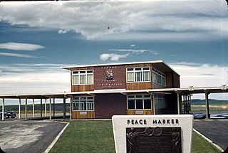
Carway is a hamlet in southern Alberta, Canada within Cardston County. It is a port of entry into the U.S. state of Montana opposite of Port of Piegan. Just on the other side of the border is the Blackfeet Indian Reservation in Glacier County, Montana.
Lewis and Clark National Forest is located in west central Montana, United States. Spanning 2,912 square miles (7,500 km2). The region was inhabited by various cultures of Native Americans for a period of at least 8,000–10,000 years. When the Lewis and Clark Expedition came to this area, different areas of the large forest territory were used by members of the Blackfeet, Sioux, Cheyenne, Flathead and Crow nations for hunting and as an area for their seasonal winter camps. The forests provided shelter from the winter.
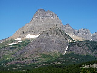
Mount Wilbur is located in the Lewis Range, Glacier National Park in the U.S. state of Montana. Plainly visible from the region of Many Glacier, the peak rises over 4,500 feet (1,372 m) above Swiftcurrent Lake and is a steep pyramid on three sides. The west slopes of the peak join to ridges along the continental divide. Much of the climbing routes are rated at class 4 to 5, with some only used once. The sedimentary rock of the mountains makes for often poor anchoring points and enhances the difficulty. A cirque on the north slopes of the mountain shelters Iceberg Lake, a popular hiking destination from Many Glacier. The mountain was named by George Bird Grinnell in 1885, for Edward R. Wilbur of New York, one of Grinnell's partners in the Forest and Stream Publishing Company, and both men were founders of the Audubon Society.

Chief Mountain is located in the U.S. state of Montana on the eastern border of Glacier National Park and the Blackfeet Indian Reservation. The mountain is one of the most prominent peaks and rock formations along the Rocky Mountain Front, a 200 miles (320 km) long overthrust fault, known as the Lewis Overthrust, which extends from central Montana into southern Alberta, Canada.

Two Medicine is the collective name of a region located in the southeastern section of Glacier National Park, in the U.S. state of Montana. It has a campground alongside Two Medicine Lake. From the period starting in the late 1890s until the completion of the Going-to-the-Sun Road in 1932, Two Medicine was one of the most visited sections of the park. Once part of a larger chalet complex, the Two Medicine Store is located along the shores of Two Medicine Lake and the building is a National Historic Landmark. The region is a starting point for many trails and tourboats take visitors out on Two Medicine Lake, where the steep south face of Rising Wolf Mountain towers above the lake. The region was considered sacred ground by several Native American tribes including the Blackfeet and they performed Vision quests here. Aside from Chief Mountain, the Two Medicine area is the most sacred section of the park to the Blackfeet.

St. Mary or Saint Mary is an unincorporated community on the western border of the Blackfeet Indian Reservation adjacent to Glacier National Park in Glacier County, Montana, United States. The village is the eastern terminus of the Going-to-the-Sun Road which bisects the park east to west, a distance of 53 mi (85 km).
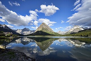
Swiftcurrent Lake is located in the Many Glacier region of Glacier National Park, in the U.S. state of Montana. The Many Glacier Hotel, the largest hotel in the park, is along the east shore of the lake. Many hiking trails originate from the area and scenic tour boats provide access to the lake for visitors.

Mount Siyeh, with a height of 10,019 feet (3,054 m), is the fifth tallest and one of six peaks over 10,000 feet (3,048 m) in Glacier National Park, Montana, United States. Mount Siyeh was named after a Blackfeet Indian, Sai-yeh, whose name means "Crazy Dog" or "Mad Wolf."

The following articles relate to the history, geography, geology, flora, fauna, structures and recreation in Glacier National Park (U.S.), the U.S. portion of the Waterton-Glacier International Peace Park.
Glacier Country, Montana is an eight-county region in the U.S. state of Montana. Glacier Country includes Flathead, Glacier, Lake, Lincoln, Mineral, Missoula, Ravalli and Sanders counties. Glacier Country is home to Glacier National Park, Flathead Lake, the Blackfeet Indian Reservation, Flathead Indian Reservation, 24 state parks, five national forests and Montana's second largest city, Missoula, Montana. As of 2022, the population of Glacier Country was 366,712.
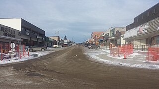
The Piegan–Carway Border Crossing connects the towns of Babb, Montana, and Cardston, Alberta, on the Canada–United States border. U.S. Route 89 on the American side joins Alberta Highway 2 on the Canadian side.

Altyn Peak is located in the Lewis Range, Glacier National Park in the U.S. state of Montana. Altyn Peak is situated just north of Swiftcurrent Lake and the Many Glacier Hotel and is easily seen from both locations. The peak is named after Dave Greenwood Altyn who was a financial backer of a local mine in the late 1800s; the mining town of Altyn was at the junction of Canyon Creek and Swiftcurrent Lake. The peak was known as Crow Feet Mountain after the last chief of the Blackfeet confederacy of tribes.


