
Glacier County is located in the U.S. state of Montana. As of the 2020 census, the population was 13,778. The county is located in northwestern Montana between the Great Plains and the Rocky Mountains, known to the Blackfeet as the "Backbone of the World". The county is geographically and culturally diverse and includes the Blackfeet Indian Reservation, Glacier National Park, and Lewis and Clark National Forest. The county is bordered by 75 miles of international boundary with two ports of entry open year-round and one seasonal international border crossing into Alberta, Canada.

Evergreen is a census-designated place (CDP) in Flathead County, Montana, United States. Its population was 8,149 at the 2020 census, up from 7,616 at the 2010 census, and 6,215 in 2000.
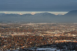
Kalispell is a city in Montana and the county seat of Flathead County, Montana, United States. The 2020 census put Kalispell's population at 24,558. Among cities in Montana, it is the 8th largest by area, 7th most populous, and 8th fastest growing from 2010 to 2020. In Montana's northwest region, it is the largest city and the commercial center of the Kalispell Micropolitan Statistical Area. The name Kalispell is a Salish word meaning "flat land above the lake".

Browning is a former town and current Census-designated place in Glacier County, Montana, United States. It is the headquarters for the Blackfeet Indian Reservation and was the only incorporated town on the Reservation. The population was 1,018 at the 2020 census.

Cut Bank is a city in and the county seat of Glacier County, Montana, United States, located just east of the "cut bank" (gorge) along Cut Bank Creek. The population was 3,056 at the 2020 census, The town began in 1891 with the arrival of the Great Northern Railway.

North Browning is a census-designated place (CDP) in Glacier County, Montana, United States. The population was 2,408 at the 2010 census.

South Browning is a census-designated place (CDP) in Glacier County, Montana, United States. The population was 1,785 at the 2010 census. South Browning is a rural village on the Blackfeet Indian Reservation. It is bordered to the north by the town of Browning.

Starr School is a census-designated place (CDP) in Glacier County, Montana, United States. The population was 252 at the 2010 census.

Augusta is an unincorporated community and census-designated place (CDP) in Lewis and Clark County, Montana, United States. The population was 309 at the 2010 census and rose to 316 in the 2020 census. The most accepted version in the naming of this town is after Augusta Hogan, thought to be the first child born in this town, the daughter of J. D. Hogan, an early rancher.

Cooke City is an unincorporated community and census-designated place (CDP) in Park County, Montana, United States. As of the 2020 census, it had a population of 77. Prior to 2010, it was part of the Cooke City-Silver Gate CDP.

Hinsdale is an unincorporated community and census-designated place in Valley County, Montana, United States. The town's population was 217 and the community's population as a whole was 583 as of the 2010 census. The community is located on the Milk River and U.S. Route 2, with Montana Highway 537 headed north out of town and South Bench Road crossing the railroad tracks and running south of town. Hinsdale has a post office with ZIP code 59241.
Little Browning is a census-designated place (CDP) in Glacier County, Montana, United States. The population was 206 at the 2010 census.
Gallatin River Ranch is a census-designated place (CDP) in Gallatin County, Montana, United States. The population was 69 at the 2010 census.
Ponderosa Pines is a census-designated place (CDP) in Gallatin County, Montana, United States. The population was 336 at the 2010 census. Formerly a 13,000-acre ranch, the land was subdivided into 10- and 20-acre parcels and sold by a Hawaiian real estate agency starting in 1972. The lots lacked water, sewer, electricity and road access, and some were on such steep terrain that building would be impossible.
Sedan is a census-designated place (CDP) in Gallatin County, Montana, United States. The population was 99 at the 2010 census. It is located on Montana Highway 86, 27 miles from Bozeman. The Zip Code is 59086.
Springhill is a census-designated place (CDP) in Gallatin County, Montana, United States. The population was 130 at the 2010 census. It is 14 miles north of Bozeman.
King Arthur Park is a census-designated place (CDP) in Gallatin County, Montana, United States. The population was 738 at the 2010 census.
Bridger is a census-designated place (CDP) in Gallatin County, Montana, United States.
Glacier Colony is a Hutterite community and census-designated place (CDP) in Glacier County, Montana, United States. It is in the northeastern part of the county, 18 miles (29 km) by road north-northeast of Cut Bank and 21 miles (34 km) west-southwest of Sunburst.
Horizon Colony is a Hutterite community and census-designated place (CDP) in Glacier County, Montana, United States. It is on the eastern side of the county, 11 miles (18 km) northeast of Cut Bank and 30 miles (48 km) northwest of Shelby.


