The Humber River is a river in Southern Ontario, Canada. It is in the Great Lakes Basin, is a tributary of Lake Ontario and is one of two major rivers on either side of the city of Toronto, the other being the Don River to the east. It was designated a Canadian Heritage River on September 24, 1999.

The Rouge River is a river in Markham, Pickering, Richmond Hill and Toronto in the Greater Toronto Area of Ontario, Canada. The river flows from the Oak Ridges Moraine to Lake Ontario at the eastern border of Toronto, and is the location of Rouge Park, the only national park in Canada within a municipality. At its southern end, the Rouge River is the boundary between Toronto and southwestern Pickering in the Regional Municipality of Durham.

The York River is a river in Renfrew County, Hastings County and Haliburton County in Ontario, Canada. The river is in the Saint Lawrence River drainage basin, and flows from the southern extension of Algonquin Provincial Park to the Madawaska River.

The Indian River is river in Renfrew County and Nipissing District in Eastern and Northeastern Ontario, Canada. It is in the Saint Lawrence River drainage basin, and is a left tributary of the Muskrat River.
The Otonabee River is a river in Peterborough County in Central Ontario, Canada. The river flows from Katchewanooka Lake, at the north end of the community of Lakefield, through the city of Peterborough to Rice Lake. It is in the Great Lakes Basin and forms part of the Trent-Severn Waterway.
Etobicoke Creek is a river in the Greater Toronto Area of Ontario, Canada. It is a tributary of Lake Ontario and runs from Caledon to southern Etobicoke, part of the City of Toronto. The creek is within the jurisdiction of the Toronto and Region Conservation Authority.

Opeongo Lake is a lake in the Saint Lawrence River drainage basin in the geographic townships of Bower, Dickson, Preston and Sproule in the Unorganized South Part of Nipissing District in Northeastern Ontario, Canada. It is the largest lake in Algonquin Provincial Park and the source of the Opeongo River. The lake's name comes from the Algonquian word opeauwingauk meaning "sandy narrows".

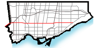
Finch Avenue is an arterial thoroughfare that travels east–west in Toronto, Ontario, Canada. The road continues west into the Regional Municipality of Peel as Regional Road 2 and east into the Regional Municipality of Durham Regions as Regional Road 37.

Mimico Creek is a stream that flows through Brampton, Mississauga and Toronto in the Greater Toronto Area of Ontario, Canada. It is 33 kilometres (21 mi) long, is in the Great Lakes Basin, and is a tributary of Lake Ontario.

The Queensway is a major street in the municipalities of Toronto and Mississauga, Ontario, Canada. It is a western continuation of Queen Street, after it crosses Roncesvalles Avenue and King Street in Toronto. The Queensway is a divided roadway from just east of Parkside Drive westerly to just beyond South Kingsway, and has a centre median dedicated to streetcar service. The road continues undivided west from the Humber River west to the Etobicoke Creek as a four- or six-lane thoroughfare.

Black Creek is a river in the Golden Horseshoe region of Ontario, Canada. It flows from the city of Vaughan in Regional Municipality of York to the Humber River in Toronto. Black Creek is smaller than most of the waterways in the Greater Toronto Area.
Skootamatta Lake is a lake in the Lake Ontario drainage basin in Addington Highlands, Lennox and Addington County, Ontario, Canada. It is 2.7 kilometres (1.7 mi) west of Cloyne, and Bon Echo Provincial Park is located just to the north. The lake's name is thought to come from Ojibwa words meaning "burnt shoreline".

The Berens River is a river in the Provinces of Manitoba and Ontario, Canada. It flows west from an unnamed lake in Kenora District, Ontario and discharges its waters into Lake Winnipeg near the village and First Nation of Berens River, Manitoba. The river has a number of lakes along its course, and many rapids.

Beaver Creek is a river in the municipalities of Markham and Richmond Hill in the Regional Municipality of York, part of the Greater Toronto Area of Ontario, Canada. It is part of the Great Lakes Basin and is a right tributary of the Rouge River.

The Montreal River is a river in Timiskaming District, Ontario, Canada. It travels 220 kilometres (137 mi) from its source at Smoothwater Lake to its mouth at Lake Timiskaming on the Ottawa River. The river is a significant source of hydroelectricity.
The Redstone River is a river in the municipality of Dysart et al, Haliburton County in central Ontario, Canada that flows from southern Algonquin Provincial Park to the Gull River.
Marie Curtis Park is a public park in Toronto, Ontario, Canada. It is located at the mouth of the Etobicoke Creek on Lake Ontario in the Long Branch neighbourhood. Marie Curtis Park was built after the devastating floods of Hurricane Hazel in 1954 destroyed 56 homes and cottages on the site, leaving 1,868 persons homeless and 81 dead. It is named after Marie Curtis, the reeve of Long Branch at the time of its construction. Long Branch at the time was a separate village; it's now amalgamated into the City of Toronto government.

The Kashabowie River is a river in southwestern Thunder Bay District in Northwestern Ontario, Canada. It is in the Great Lakes Basin and is a tributary of the Shebandowan Lakes.

The Toronto waterway system comprises a series of natural and man-made watercourses in the Canadian city of Toronto. The city is dominated by a large river system spanning most of the city including the Don River, Etobicoke Creek, Highland Creek, the Humber River, Mimico Creek and the Rouge River.
Doorley Creek is a stream in Greater Madawaska, Renfrew County in Eastern Ontario, Canada. It is in the Saint Lawrence River drainage basin and is a right tributary of Black Donald Creek.