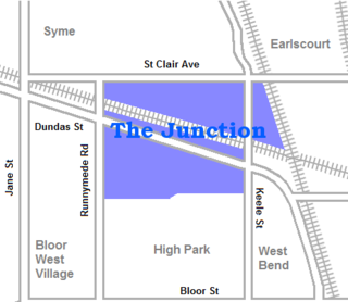
The Junction is a neighbourhood in Toronto, Ontario, Canada, that is near the West Toronto Diamond, a junction of four railway lines in the area. The neighbourhood was previously an independent city called West Toronto, that was also its own federal electoral district until amalgamating with the city of Toronto in 1909. The main intersection of the area is Dundas Street West and Keele Street. The Stockyards is the northeastern quadrant of the neighbourhood.

Riverdale is a large neighbourhood in Toronto, Ontario, Canada. It is bounded by the Don River Valley to the west, Danforth Avenue and Greektown to the north, Jones Avenue, the CN/GO tracks, Leslieville to the east, and Lake Shore Boulevard to the south.

Parkdale is a neighbourhood and former village in Toronto, Ontario, Canada, west of downtown. The neighbourhood is bounded on the west by Roncesvalles Avenue; on the north by the CP Rail line where it crosses Queen Street and Dundas Street; on the east by Dufferin Street from Queen Street south; and on the south by Lake Ontario. The original village incorporated an area north of Queen Street, east of Roncesvalles from Fermanagh east to the main rail lines, today known as part of the Roncesvalles neighbourhood. The village area was roughly one square kilometre in area. The City of Toronto government extends the neighbourhood boundaries to the east, south of the CP Rail lines, east to Atlantic Avenue, as far south as the CN Rail lines north of Exhibition Place, the part south of King Street commonly known as the western half of Liberty Village neighbourhood.

A Little Manila, also known as a Manilatown or Filipinotown, is a community with a large Filipino immigrant and descendant population. Little Manilas are enclaves of Overseas Filipinos consisting of people of Filipino origin living outside of the Philippines.

Tuxedo is a residential suburb of Winnipeg, Manitoba. It is located about 7 kilometres southwest of downtown Winnipeg, and borders the Assiniboine River and Assiniboine Park on the north, Shaftesbury Boulevard on the west, Route 90 to the East and McGillvary Boulevard to the South. Prior to 1972, the community was incorporated as the Town of Tuxedo.

Fort Rouge is a district of Winnipeg, Manitoba, in Canada. Located in the south-central part of the city, it is bounded on the north by the Assiniboine River, on the east and south by the Red River, and on the west by Stafford Street and Pembina Highway.

Osborne Village is a neighbourhood of Winnipeg, Manitoba. The area is bordered by the Assiniboine River on the north and west, Harkness Station on the east, and the Osborne Underpass on the south.

Crescentwood is a neighbourhood in the River Heights area of Winnipeg, Manitoba, Canada. It is bordered on the north by Academy Road, on the east by the Assiniboine River, on the south by Corydon Avenue, and on the west by Cambridge Street.

Downtown Winnipeg is an area of Winnipeg located near the confluence of the Red and Assiniboine rivers. It is the oldest urban area in Winnipeg, and is home to the city's commercial core, city hall, the seat of Manitoba's provincial government, and a number of major attractions and institutions.

East Vancouver is a region within the city of Vancouver, British Columbia, Canada. Geographically, East Vancouver is bordered to the north by Burrard Inlet, to the south by the Fraser River, and to the east by the city of Burnaby. East Vancouver is divided from Vancouver's "West Side" by Ontario Street.

The West End is a mostly residential area of Downtown Winnipeg, Manitoba, Canada. It includes the neighbourhoods of Armstrong's Point, Colony, Daniel McIntyre, Minto, Sargent Park, Spence, St. Matthews, West Broadway, and Wolseley.

Chinatown is an neighbourhood in Winnipeg, Manitoba, that was formed in 1909 and serves as an enclave of Chinese expatriates.

Winnipeg lies at the bottom of the Red River Valley, a low-lying flood plain with an extremely flat topography. This valley was formed by the ancient glacial Lake Agassiz which has rich deposits of black soil. Winnipeg is on the eastern edge of the Canadian Prairies in Western Canada; it is known as the 'Gateway to the West'. It is relatively close to many large Canadian Shield lakes and parks, as well as Lake Winnipeg. Winnipeg is bordered by tallgrass prairie to the west and south and the aspen parkland to the northeast.
Windsor, Ontario, has a very diverse population, and this diversity is shown in its many neighbourhoods. Windsor has twenty in all, ranging from rural farmland to densely built-up areas.
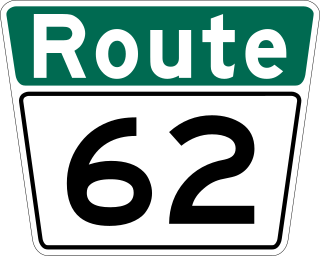
Route 62 is a major north–south arterial route in Winnipeg, Manitoba, that has eight different street names.

Osborne Junction, more commonly known as Confusion Corner, is a street intersection in Winnipeg, Manitoba. Located at the junction of City Route 62 and City Route 42 in the city's Fort Rouge neighbourhood, the intersection is a major traffic hub through which most traffic between downtown and the southwest quadrant of the city must pass, but is infamous for being complex and difficult for unfamiliar or distracted drivers to navigate correctly.

Runnymede is a neighbourhood in Toronto, Ontario, Canada located north of Bloor Street West between Jane Street and Runnymede Road north to Dundas Street West. It is located directly north of the former village of Swansea and west of the High Park North neighbourhood. The immediate area around Bloor Street is commonly known as Bloor West Village after the shopping area along Bloor Street, whereas the area to the north is considered the Runnymede neighbourhood.
Chinatowns in Canada generally exist in the large cities of Vancouver, Ottawa, Calgary, Edmonton, Toronto, and Montreal, and existed in some smaller towns throughout the history of Canada. Prior to 1900, almost all Chinese were located in British Columbia, but have spread throughout Canada thereafter. From 1923 to 1967, immigration from China was suspended due to exclusion laws. In 1997, the handover of Hong Kong to China caused many from there to flee to Canada due to uncertainties. Canada had about 25 Chinatowns across the country between the 1930s to 1940s, some of which have ceased to exist.

Chinatown, Toronto is a Chinese ethnic enclave located in the city's downtown core of Toronto, Ontario, Canada. It is centred at the intersections of Spadina Avenue and Dundas Street West.
