Llantrisant Fawr | |
---|---|
Community | |
Location within Monmouthshire | |
Principal area | |
Country | Wales |
Sovereign state | United Kingdom |
Police | Gwent |
Fire | South Wales |
Ambulance | Welsh |
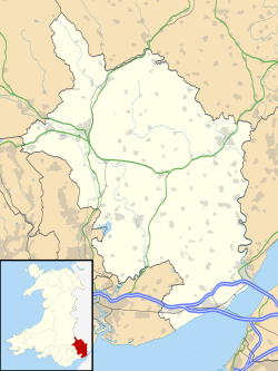
Llantrisant Fawr is a community in Monmouthshire, Wales. Villages within the community include Llantrisant and Llanllowell. The community council has three wards: Llantrisant, Llangwm and Llansoy, after Llangwm community was absorbed with boundary changes in May 2022. The population in the 2011 census was 475. [1]
Llantrisant is a town in the county borough of Rhondda Cynon Taf, within the historic county boundaries of Glamorgan, Wales, lying on the River Ely and the Afon Clun. The three saints of the town's name are SS. Illtyd, Gwynno, and Dyfodwg. Llantrisant is a hilltop settlement, at an altitude of 174 m (571 ft) above sea level. The town is home to the Royal Mint.
Rhondda, or the Rhondda Valley, is a former coalmining area in South Wales, historically in the county of Glamorgan. It takes its name from the River Rhondda, and embraces two valleys – the larger Rhondda Fawr valley and the smaller Rhondda Fach valley – so that the singular "Rhondda Valley" and the plural are both commonly used. The area forms part of the South Wales Valleys. From 1897 until 1996 there was a local government district of Rhondda. The former district at its abolition comprised 16 communities. Since 1996 these 16 communities of the Rhondda have been part of Rhondda Cynon Taf County Borough. The area of the former district is still used as the Rhondda Senedd constituency and Westminster constituency, having an estimated population in 2020 of 69,506. It is most noted for its historical coalmining industry, which peaked between 1840 and 1925. The valleys produced a strong Nonconformist movement manifest in the Baptist chapels that moulded Rhondda values in the 19th and early 20th centuries. It is also known for its male voice choirs and in sport and politics.
Ystradyfodwg or Ystrad Dyfodwg was an ancient upland parish in Glamorgan, Wales. It is believed to have been named after Dyfodwg a 6th-century saint or chieftain. The parish included most of the area which would later be known as Rhondda named for the parish rivers, Rhondda Fawr and Rhondda Fach.
Beddau is a large former mining village situated within the South Wales Valleys around 1.5 miles (2.4 km) from Llantrisant and 4 miles (6.4 km) from the larger town of Pontypridd in the county borough of Rhondda Cynon Taf, South Wales.
Taff-Ely was a local government district with borough status in Wales from 1974 to 1996.
Usk was an ancient hundred of Monmouthshire.
Talbot Green is a town just north of the M4 motorway, in the County Borough of Rhondda Cynon Taf, Wales in the United Kingdom. The town is part of Llantrisant Community Council.
Llanbadarn Fawr is a village and community in Ceredigion, Wales. It is on the outskirts of Aberystwyth next to Penparcau and Southgate. It forms the eastern part of the continually built-up area of Aberystwyth. It holds two electoral wards, Padarn and Sulien which elect a Ceredigion County Councillor each and several Llanbadarn Fawr Community Councillors. At the 2001 census its population as a community was recorded at 2,899, increasing to 3,380 at the 2011 census.
Llangwm is a small village, parish and community of around 450 properties situated on the Llangwm Pill off the River Cleddau estuary near Haverfordwest, Pembrokeshire, Wales. It has a history of mining and fishing and is in the largely English-speaking south of the county.
Llantwit Fardre is a large village and community situated on the A473, Pontypridd to Bridgend, road near the Welsh towns of Pontypridd and Llantrisant. Llantwit Fardre is also the name of the old parish and the community area that takes in the villages of Llantwit Fardre, Tonteg and Church Village. It is in the county of Rhondda Cynon Taf.
Llangwm is a small rural village and former community, now in the community of Llantrisant Fawr, in Monmouthshire, south east Wales. It is located 3 miles (4.8 km) east of Usk, on the B4235 Chepstow to Usk road. The main village is at Llangwm Uchaf, with a smaller and more dispersed settlement about 1 mile (1.6 km) to the north-east at Llangwm Isaf .The other settlement in the community is Llansoy. In 2022 the community was abolished and merged with Llantrisant Fawr.
Llantrisant is a village in Monmouthshire, south east Wales, United Kingdom. The community population at the 2011 census was 475.
Llanllowell is a village in Monmouthshire, southeast Wales, in the United Kingdom. It is two miles southeast of Usk, in the community of Llantrisant Fawr.
Llan and its variants are a common element of Celtic placenames in the British Isles and Brittany, especially of Welsh toponymy. In Welsh the name of a local saint or a geomorphological description follows the Llan morpheme to form a single word: for example Llanfair is the parish or settlement around the church of St. Mair. Goidelic toponyms end in -lann.
Llywel is a small village located on the A40, about 4 miles (6.4 km) west of Sennybridge in Powys, Wales. The Afon Gwydderig runs through the village, not far from its source. Llywel also gives its name to a community. The main settlement in the community is Trecastle. According to the 2001 Census the population of the Llywel community is 524, falling to 497 in the 2011 Census. The village was historically in Brecknockshire.
Llangwm is a village and community in Conwy County Borough, in Wales. It is located in the valley of the Afon Medrad, close to the borders with Denbighshire and Gwynedd, 2.9 miles (4.7 km) south of Cerrigydrudion, 7.8 miles (12.6 km) west of Corwen and 27.9 miles (44.9 km) south east of Conwy. At the 2001 census the community had a population of 516, decreasing to 470 at the 2011 census. It is one of three communities in the Uwchaled ward, and includes the hamlets of Dinmael, Gellioedd, Glan-yr-afon, Llangwm, Maerdy, and Ty-nant.
Rhondda Tramways Company operated a tramway service in Rhondda, Wales, between 1904 and 1934.
Allt-y-Bela in Llangwm, Monmouthshire, Wales, is a house of late medieval origin with additions from the sixteenth to the twenty-first centuries. The name means "wood/wooded slope of the wolf/marten" in Welsh. During the early seventeenth century, it was owned by Roger Edwards, a wealthy Midlands merchant and the founder of Usk Grammar School. Edwards made significant alterations in the Renaissance style to the medieval cruck house. By the twentieth century, the house was in ruins until restored by the Spitalfields Historic Buildings Trust in the early twenty-first century. Now owned by the garden designer Arne Maynard, the house is a Grade II* listed building recognising its significance as an "exceptionally important sub-medieval house with ambitious early renaissance additions".