Mitchel Troy
| |
---|---|
View looking north-west over Troy House, Mitchel Troy | |
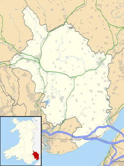
Location within Monmouthshire | |
Population | 1,253 (2011) [1] |
OS grid reference | SO493103 |
Community |
|
Principal area | |
Preserved county | |
Country | Wales |
Sovereign state | United Kingdom |
Post town | USK |
Postcode district | NP15 |
Post town | MONMOUTH |
Postcode district | NP25 |
Dialling code | 01600 |
Police | Gwent |
Fire | South Wales |
Ambulance | Welsh |
UK Parliament | |
Mitchel Troy (Welsh : Llanfihangel Troddi, that is "church of St Michael on the River Trothy") is a village and community in Monmouthshire, south east Wales, in the United Kingdom. It is located 3 miles south west of the county town of Monmouth, just off the A40 road leading towards Raglan. Settlements within the community include Tregare, Dingestow, Cwmcarvan and Wonastow.
The English name of the parish derives from the name of the river, the Welsh Troddi becoming Trothy and then Troy. The addition "Mitchel" is thought not to derive from the church's dedication to St Michael, but rather as a variant of the word "much" or "mickle", as also found at Mitcheldean in Gloucestershire, and used to differentiate the village from the nearby manor of Troy Parva. [2]
John de Troye, Lord Chancellor of Ireland (died 1371), was born here early in the fourteenth century. Nathaniel Armstrong Wells, author, eldest son of the first black High Sheriff of Monmouthshire Nathaniel Wells, was christened here on 24 March 1806. [3]
The church of St Michael and All Angels dates back to the 13th century though the church was thoroughly restored in the 1870s in the Decorated style. The cleric and writer Adam of Usk was the rector in 1382–85; [2] [4] and the final resident incumbent of Mitchel Troy with Cwmcarvan, Arthur Walter Sneyd (1900-1980), who retired in 1971, is of note because he succeeded in taking both his Bachelor of Arts and Master of Arts degrees at Jesus College, Oxford within two years of retiring. [5] Following Sneyd's departure, the parish became served from Overmonnow and more recently it has been incorporated into the Monmouth group of parishes. [6]
Troy House, about 1½ miles north east of the church, was largely rebuilt after about 1680, on the site of an earlier building, for the Duke of Beaufort, after the family seat at Raglan Castle had fallen into ruin. [2] [4] The house remained in the Somerset family until it was sold in 1901, after which it became a convent school and later, from 1935, an approved school. In 2008, proposals have been made for its conversion into residential apartments. [7]
Mitchel Troy is also the name of the electoral division, coterminous with the community. The division elects a county councillor to Monmouthshire County Council. [8]
Monmouthshire, also known as the County of Monmouth, is one of thirteen historic counties of Wales and a former administrative county. It corresponds approximately to the present principal areas of Monmouthshire, Blaenau Gwent, Newport and Torfaen, and those parts of Caerphilly and Cardiff east of the Rhymney River.
Llanvapley is a village in the community of Gobion Fawr, in Monmouthshire, south east Wales, United Kingdom. Llan has replaced the (earlier) Eglwys (1254).
Raglan (; is a village and community in Monmouthshire, south east Wales, United Kingdom. It is located some 9 miles south-west of Monmouth, midway between Monmouth and Abergavenny on the A40 road very near to the junction with the A449 road. The fame of the village derives from Raglan Castle, built for William ap Thomas and now maintained by Cadw. The community includes the villages of Llandenny and Pen-y-clawdd. Raglan itself has a population of 1,183.
Southern Monmouthshire was a parliamentary constituency in Monmouthshire. It returned one Member of Parliament (MP) to the House of Commons of the Parliament of the United Kingdom.
Penmain or Penmaen is a hamlet and community in Caerphilly county borough, south Wales, within the historic boundaries of Monmouthshire. It is situated in the Sirhowy valley, 3 miles (4.8 km) East of Blackwood. It is contiguous with, if not completely encompassed by, the larger village of Oakdale, which forms most of the community urban area.
Llangattock-Vibon-Avel is a rural parish and former community, now in the community of Whitecastle in Monmouthshire, south-east Wales, in the United Kingdom. It is located 5 miles (8.0 km) west of Monmouth and some 13 miles (21 km) east of Abergavenny, just off the B4233 old road between the two. Villages within the former community include Llangattock itself, Skenfrith, Rockfield, and Newcastle.
Llanvihangel-Ystern-Llewern is a village in the community of Whitecastle, in Monmouthshire, south east Wales. It is located between Abergavenny and Monmouth and north of Raglan. The River Trothy passes close by.
Dingestow is a small village in Monmouthshire, Wales. It is located 4 miles (6.4 km) south-west of Monmouth and approximately the same distance north-east of Raglan in rural Monmouthshire. The River Trothy passes through the village.
Cwmcarvan is a small rural village in Monmouthshire, south east Wales. It is located 4 miles south west of Monmouth and about 4 miles east of Raglan, off the old A40 road two miles NW of Trellech.
St. Arvans is a village and community in Monmouthshire, south-east Wales. It is located two miles north west of Chepstow, close to Chepstow Racecourse, Piercefield House and the Wye Valley AONB. It is connected by a segregated bicycle path to the edge of Chepstow.
Llansoy is a small village in Monmouthshire, south east Wales, United Kingdom, located about 3 miles (4.2 km) south east of Raglan.
Dixton is a small village located 1 mile (1.6 km) north east of Monmouth, on the banks of the River Wye, in Monmouthshire, south east Wales. The parish originally comprised the two manors of Dixton Newton and Dixton Hadnock, on either side of the river.
Penrhos is a village in the community of Whitecastle in Monmouthshire, south east Wales, United Kingdom.
Pen-y-clawdd is a village in Monmouthshire, south east Wales, situated between Raglan and Monmouth. The village is the site of a medieval fortification and there is a historic church with an ancient cross in the churchyard which is a scheduled monument.
Llanfihangel Tor-y-Mynydd is a small rural village in the community of Devauden, Monmouthshire, Wales. It is located within the Vale of Usk, about 9 miles south west of Monmouth and 6 miles east of the town of Usk, between the villages of Devauden and Llansoy.
Troy House is a Welsh historic house, on a "ducal" scale, north-east of Mitchel Troy, Monmouthshire. The original house belonged to Blanche Herbert, Lady Troy, of the Herbert family of Raglan Castle, who owned great estates in South Wales as Marquesses of Worcester and later Dukes of Beaufort. The present structure, overlooking the River Trothy was constructed from 1681 to 1684 as a wedding present for Charles Somerset by his father, Henry Somerset, 1st Duke of Beaufort. Troy House is a Grade II* listed building and its gardens and park are listed, also at Grade II*, on the Cadw/ICOMOS Register of Parks and Gardens of Special Historic Interest in Wales.
Overmonnow is a suburb of the town of Monmouth, in Wales, which is located to the west of the River Monnow and the Monnow Bridge. It developed in the Middle Ages, when it was protected by a defensive ditch, the Clawdd-du or "Black Dyke", the remains of which are now protected as an ancient monument. In later centuries the area became known as "Little Monmouth" or "Cappers' Town".
Monmouth Poor Law Union was formed on 11 July 1836 in Monmouth, Wales
Lydart is a dispersed hamlet within the community of Mitchel Troy, Monmouthshire, Wales. It is located about 3 miles (4.8 km) south-west of Monmouth, 3 miles (4.8 km) north of Trellech, and 1 mile (1.6 km) south-east of Mitchel Troy village, on the top of an escarpment which slopes steeply down to the valley of the River Trothy. The B4293 road passes through the area.
The Church of St Michael and All Angels, is a parish church in the village of Mitchel Troy, Monmouthshire, Wales. The Grade II* listed building stands in the centre of the village, on the north side of the old road from Monmouth to Raglan, 2.5 miles (4.0 km) south-west of Monmouth.