Cross Ash | |
---|---|
Old Post Office in Cross Ash | |
Location within Monmouthshire | |
OS grid reference | SO407197 |
Principal area | |
Preserved county | |
Country | Wales |
Sovereign state | United Kingdom |
Post town | ABERGAVENNY |
Postcode district | NP7 |
Dialling code | 01873 |
Police | Gwent |
Fire | South Wales |
Ambulance | Welsh |
UK Parliament | |
Cross Ash is a village in Monmouthshire, south east Wales. It is located on the B4521 road between Abergavenny and Skenfrith, some six miles north east of Abergavenny. The Welsh name for Cross Ash is Croesonnen, although it is not currently in official use.
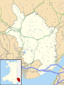
Cross Ash is situated in a rural part of north-east Monmouthshire. The village is located on the southern foothills of Graig Syfyrddin, where several country lanes converge on the B4521 road. It is virtually equidistant between the 'three castles of Gwent', White Castle, Skenfrith Castle and Grosmont Castle. [1]
Cross Ash has a primary school which serves an expansive rural area. [2] Next door to the school is a village hall which serves as the venue for the annual Cross Ash Show and Fun Day. [3] There was formerly a post office and petrol station in the village however both are now closed.
The Welsh name is recorded in the form Croesonen on Charles Bugden's 1813 map of the area, referring to what is now Cross Ash Farm. [4] It contains the common Welsh words croes 'cross' and onnen 'ash tree' and, like Cross Ash, means 'the cross of the ash tree'.
In 2004 the name, in the form Croes Onnen, [5] was added to the road signs for the village. This was opposed by campaigners who suggested it had no historical basis and who claimed there had been no consultation with local people. [6] The Welsh name was removed from the local road signs in 2011. [7] [8]
Cross Ash Primary school uses 'Ysgol Gynradd Croes Onnen' as its Welsh name, as seen on signage erected in 2021. [9]
Abergavenny is a market town and community in Monmouthshire, Wales. Abergavenny is promoted as a Gateway to Wales; it is approximately 6 miles (10 km) from the border with England and is located where the A40 trunk road and the recently upgraded A465 Heads of the Valleys road meet.
White Castle, also known historically as Llantilio Castle, is a ruined castle near the village of Llantilio Crossenny in Monmouthshire, Wales. The fortification was established by the Normans in the wake of the invasion of England in 1066, to protect the route from Wales to Hereford. Possibly commissioned by William fitz Osbern, the Earl of Hereford, it comprised three large earthworks with timber defences. In 1135, a major Welsh revolt took place and in response King Stephen brought together White Castle and its sister fortifications of Grosmont and Skenfrith to form a lordship known as the "Three Castles", which continued to play a role in defending the region from Welsh attack for several centuries.
Monmouthshire is a county in the south east of Wales. It borders Powys to the north; the English counties of Herefordshire and Gloucestershire to the north and east; the Severn Estuary to the south, and Torfaen, Newport and Blaenau Gwent to the west. The largest town is Abergavenny, and the administrative centre is Usk.
Llanvapley is a village in the community of Gobion Fawr, in Monmouthshire, south east Wales, United Kingdom. Llan has replaced the (earlier) Eglwys (1254). This village lies 4 miles north east of 2023’s Best Places to Live listed town, Abergavenny.
Skenfrith Castle is a ruined castle in the village of Skenfrith in Monmouthshire, Wales. The fortification was established by the Normans in the wake of the invasion of England in 1066, to protect the route from Wales to Hereford. Possibly commissioned by William fitz Osbern, the Earl of Hereford, the castle comprised earthworks with timber defences. In 1135, a major Welsh revolt took place and in response King Stephen brought together Skenfrith Castle and its sister fortifications of Grosmont and White Castle to form a lordship known as the "Three Castles", which continued to play a role in defending the region from Welsh attack for several centuries.
Raglan (; is a village and community in Monmouthshire, south-east Wales, United Kingdom. It is located some 9 miles south-west of Monmouth, midway between Monmouth and Abergavenny on the A40 road very near to the junction with the A449 road. It is the location of Raglan Castle, built for William ap Thomas and now maintained by Cadw. The community includes the villages of Llandenny and Pen-y-clawdd. Raglan itself has a population of 1,183.
Grosmont is a village and community near Abergavenny in Monmouthshire, Wales. The population taken at the 2011 census was 920. The wider community (parish) includes the villages of Llangattock Lingoed, Llangua and Llanvetherine.
Grosmont Castle is a ruined castle in the village of Grosmont, Monmouthshire, Wales. The fortification was established by the Normans in the wake of the invasion of England in 1066, to protect the route from Wales to Hereford. Possibly commissioned by William fitz Osbern, the Earl of Hereford, it was originally an earthwork design with timber defences. In 1135, a major Welsh revolt took place, and in response King Stephen brought together Grosmont Castle and its sister fortifications of Skenfrith and White Castle to form a lordship known as the "Three Castles", which continued to play a role in defending the region from Welsh attack for several centuries.
The Three Castles Walk is a waymarked long distance footpath and recreational walk located in north-east Monmouthshire, Wales.
Llangynidr is a village, community and electoral ward in Powys, Wales, about 4 miles (6.4 km) west of Crickhowell and 9 miles (14.5 km) south-east of Brecon. The River Usk flows through the village as does the Monmouthshire and Brecon Canal. It is in the historic county of Brecknockshire.
Llanvihangel Crucorney is a small village in the community (parish) of Crucorney, Monmouthshire, Wales. It is located 5 miles (8.0 km) north of Abergavenny and 18 miles (29 km) southwest of Hereford, England on the A465 road.
Llantilio Crossenny is a small village and much larger former community, now in the community of Whitecastle, in Monmouthshire, south east Wales, in the United Kingdom. It is situated between the two towns of Abergavenny and Monmouth on the B4233 road. The community included Penrhos, and Llanvihangel-Ystern-Llewern.
Llangattock Lingoed is a small rural village in Monmouthshire, south east Wales. It is located approximately five miles north of Abergavenny, between Abergavenny and Grosmont, a few miles south of the Wales-England border. Offa's Dyke Path passes through the village. The village is near the Black Mountains and the Brecon Beacons National Park.
Skenfrith is a small village in Monmouthshire, south-east Wales. It is located on the River Monnow, close to the border between Wales and England, about 6 miles (9.7 km) north-west of Monmouth.
Llanvetherine is a village in the community of Skenfrith, Monmouthshire, Wales. It is located five miles north east of Abergavenny on the B4521 road to Ross-on-Wye. The name comes from the Welsh Saint Gwytherin.
Rockfield is a small village in the community of Whitecastle, Monmouthshire, Southeast Wales. It is located beside the River Monnow, about 2 miles (3.2 km) north-west of Monmouth, at the junction of the B4233 to Abergavenny and the B4347 to Grosmont. Rockfield Studios is situated just south of the village.
Monmouthshire is a county and principal area of Wales. It borders Torfaen and Newport to the west; Herefordshire and Gloucestershire to the east; and Powys to the north. The largest town is Abergavenny, with the other major towns being Chepstow, Monmouth, and Usk. The county is 850 km2 in extent, with a population of 95,200 as of 2020. The present county was formed under the Local Government (Wales) Act 1994, which came into effect in 1996, and comprises some sixty percent of the historic county. Between 1974 and 1996, the county was known by the ancient title of Gwent, recalling the medieval Welsh kingdom. In his essay on local government in the fifth and final volume of the Gwent County History, Robert McCloy suggests that the governance of "no county in the United Kingdom in the twentieth century was so transformed as that of Monmouthshire".
The Three Castles was a former medieval lordship, comprising the fortifications of Grosmont, Skenfrith and White Castle in Monmouthshire, Wales. The castles were established by the Normans in the wake of their conquest of England in 1066, to protect the route from Wales to Hereford. Possibly commissioned by William fitz Osbern, the Earl of Hereford, they initially comprised earthwork fortifications with timber defences. In 1135, a major Welsh revolt took place and in response King Stephen brought the castles together to form the lordship, which continued to play a role in defending the region for several centuries.
Grosmont Town Hall is a municipal building in Grosmont, Monmouthshire, Wales. The structure, which is the meeting place of Grosmont Community Council, is a Grade II listed building.