Catbrook

Last updated

Catbrook
Former school building, Catbrook - geograph.org.uk - 1332331.jpg
Old Catbrook schoolhouse
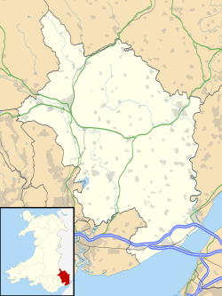
Monmouthshire UK location map.svg
Red pog.svg
Catbrook
Location within Monmouthshire
Principal area
Ceremonial county
Country Wales
Sovereign state United Kingdom
Post town USK
Postcode district NP
Police Gwent
Fire South Wales
Ambulance Welsh
UK Parliament
List of places
UK
Wales
Monmouthshire
51°43′15″N2°42′33″W / 51.72088°N 2.70929°W / 51.72088; -2.70929 Coordinates: 51°43′15″N2°42′33″W / 51.72088°N 2.70929°W / 51.72088; -2.70929

Catbrook (Welsh : Catffrwd) is a village in Monmouthshire, south east Wales, United Kingdom. [1] The population in 2011 was 412. [2]

Contents

Location

Catbrook is 6 miles (9.7 km) south of Monmouth and 1 mile (1.6 km) north west of Tintern. [3] It is in the community of Trellech United, just under two miles south of Trellech village.

History and amenities

Catbrook is set high above Tintern Abbey and the Wye Valley AONB and overlooks the Forest of Dean across the river in Gloucestershire.

In 2004 Melanie Chisholm, singer and member of the Spice Girls, purchased a house in the village. [4]

Related Research Articles

Wye Valley Walk Long-distance footpath in Wales and England

The Wye Valley Walk is a long distance footpath in Wales and England following the course of the River Wye.

Tintern Abbey

Tintern Abbey was founded on 9 May 1131 by Walter de Clare, Lord of Chepstow. It is situated adjacent to the village of Tintern in Monmouthshire, on the Welsh bank of the River Wye, which at this location forms the border between Monmouthshire in Wales and Gloucestershire in England. It was the first Cistercian foundation in Wales, and only the second in Britain.

Trellech Human settlement in Wales

Trellech is a village and parish in Monmouthshire, south-east Wales. Located 5 miles (8 km) south of Monmouth and 4 miles (6.4 km) north-north-west of Tintern, Trellech lies on a plateau above the Wye Valley on the southern fringes of 320 acres (130 ha) of woodland in an Area of Outstanding Natural Beauty. Three Bronze Age standing stones are situated in the village, known as Harold's Stones, which overlook the historic church of St Nicholas, a Grade I listed building.

Monmouthshire County in Wales

Monmouthshire is a county in the south-east of Wales. The name derives from the historic county of the same name; the modern county covers the eastern three-fifths of the historic county. The largest town is Abergavenny, with other towns and large villages being: Caldicot, Chepstow, Monmouth, Magor and Usk. It borders Torfaen, Newport and Blaenau Gwent to the west; Herefordshire and Gloucestershire to the east; and Powys to the north.

Tintern Human settlement in Wales

Tintern is a village and community on the west bank of the River Wye in Monmouthshire, Wales, close to the border with England, about 5 miles (8.0 km) north of Chepstow. It is popular with tourists, in particular for the scenery and the ruined Tintern Abbey. Modern Tintern has been formed through the coalescence of two historic villages; Tintern Parva, forming the northern end of the village, and Chapel Hill, which forms the southern end. The village is designated as a Conservation Area.

Llandogo Human settlement in Wales

Llandogo is a small village in Monmouthshire, south Wales, between Monmouth and Chepstow in the lower reaches of the Wye Valley AONB, two miles north of Tintern. It is set on a steep hillside overlooking the River Wye and across into the Forest of Dean in Gloucestershire, England. The 2011 census population was 547.

Wye Valley Area of Outstanding Natural Beauty in England and Wales

The Wye Valley Area of Outstanding Natural Beauty is an internationally important protected landscape straddling the border between England and Wales.

A466 road

The A466, also known as the Wye Valley Road, is a road from Hereford, England to Chepstow, Wales via Monmouth, Tintern and the Wye Valley.

Devauden Human settlement in Wales

Devauden is a village and community in Monmouthshire, southeast Wales. It is located between Chepstow and Monmouth near the top of the Trellech ridge on the B4293 road. The community covers an area of 3,790 hectares (14.6 sq mi). The community includes the villages of Itton and Wolvesnewton, Llanfihangel-tor-y-mynydd and Newchurch.

Cwmcarvan Human settlement in Wales

Cwmcarvan is a small rural village in Monmouthshire, south east Wales. It is located 4 miles south west of Monmouth and about 4 miles east of Raglan, off the old A40 road two miles NW of Trellech.

Trelleck Grange

Trelleck Grange is a small hamlet in a rural area of Monmouthshire, south east Wales, United Kingdom, about seven miles south of Monmouth.

Llanishen, Monmouthshire Human settlement in Wales

Llanishen is a village in Monmouthshire, south east Wales, United Kingdom. It is located 7 miles (11 km) south west of Monmouth and 3 miles (4.8 km) south of Trellech on the B4293 road, although the main part of the village is set immediately to the west of the road, overlooking the Vale of Usk.

Llangovan Human settlement in Wales

Llangovan is a small village in Monmouthshire, south east Wales, United Kingdom. It is located 5 miles (8.0 km) south west of Monmouth.

Kilgwrrwg Human settlement in Wales

Kilgwrrwg is a rural parish in Monmouthshire, south east Wales, United Kingdom. It is located 7 miles (11 km) north west of Chepstow and 7 miles (11 km) south east of Usk in a network of country lanes running through the rolling hills below the Trellech ridge.

Wye Valley Railway Disused railway in England and Wales

The Wye Valley Railway was a standard gauge railway that ran for nearly 15 miles (24 km) along the Lower Wye Valley between the towns of Chepstow and Monmouth, crossing several times between Wales and England. Opened on 1 November 1876, it was leased to, and worked by, the Great Western Railway (GWR), before being fully absorbed by the GWR in 1905.

Penterry Human settlement in Wales

Penterry is a small rural parish of 479 acres (1.94 km2) in Monmouthshire, Wales. It is located between the villages of St. Arvans and Tintern, about 4 miles (6.4 km) north of Chepstow, within the Wye Valley Area of Outstanding Natural Beauty and about 2 miles (3.2 km) from the border with England. It now contains an isolated parish church adjoining the site of a deserted village, and a few farms.

Beacon Hill, Monmouthshire

Beacon Hill is the highest hill in eastern Monmouthshire, South Wales. It is located 0.6 miles (0.97 km) due east of the village of Trellech, and 1 mile (1.6 km) north-west of Llandogo. Its crowning point at 306m / 1006 ft above sea level is marked by an Ordnance Survey triangulation pillar. The summit, eastern slopes and uppermost western slopes are owned by Natural Resources Wales which manages the area not only for timber production but for recreation also.

Lydart Hamlet in Wales

Lydart is a dispersed hamlet within the community of Mitchel Troy, Monmouthshire, Wales. It is located about 3 miles (4.8 km) south-west of Monmouth, 3 miles (4.8 km) north of Trellech, and 1 mile (1.6 km) south-east of Mitchel Troy village, on the top of an escarpment which slopes steeply down to the valley of the River Trothy. The B4293 road passes through the area.

Royal George Hotel, Tintern

The Royal George Hotel is a hotel in Tintern located 5 miles (8.0 km) to the north of Chepstow, Monmouthshire, Wales. It is situated beside the A466 road, across the road from the River Wye, on the corner of an unclassified road to Devauden and Trellech. It is a Grade II listed building.

Trellech United Community/Electoral ward in Wales

Trellech United is a community and electoral ward in the county of Monmouthshire, Wales. It lies south of the county town of Monmouth next to the Wales-England border.

References

  1. The Catbrook website, Retrieved 3 January 2016
  2. "Custom report - Nomis - Official Labour Market Statistics". www.nomisweb.co.uk. Retrieved 30 July 2021.
  3. WalesOnline (7 June 2004). "Mel C makes a home in Wales" . Retrieved 8 October 2018.