Llanvihangel-Ystern-Llewern

Last updated

Llanvihangel-Ystern-Llewern
  • Welsh: Llanfihangel-Ystum-Llywern
St. Michael's of the Fiery Meteor - geograph.org.uk - 167322.jpg
Church of St Michael
Monmouthshire UK location map.svg
Red pog.svg
Llanvihangel-Ystern-Llewern
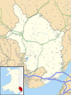
Location within Monmouthshire
OS grid reference SO432139
Community
Principal area
Ceremonial county
Country Wales
Sovereign state United Kingdom
Post town MONMOUTH
Postcode district NP25
Dialling code 01600
Police Gwent
Fire South Wales
Ambulance Welsh
UK Parliament
List of places
UK
Wales
Monmouthshire
51°49′16″N2°49′26″W / 51.821226°N 2.824012°W / 51.821226; -2.824012 Coordinates: 51°49′16″N2°49′26″W / 51.821226°N 2.824012°W / 51.821226; -2.824012

Llanvihangel-Ystern-Llewern (Welsh : Llanfihangel-Ystum-Llywern) is a village in the community of Whitecastle, in Monmouthshire, south east Wales. It is located between Abergavenny and Monmouth and north of Raglan. The River Trothy passes close by.
Contents

History and amenities

Joseph Bradney, the antiquarian and author of A History of Monmouthshire from the Coming of the Normans into Wales down to the Present Time , acquired the nearby estate of Tal-y-coed Court, partly by inheritance and partly through purchase, where he settled at an early age. [1] A Latin tablet in St Michael's Church in the village records his achievements. Bradney was also the owner of The Pant in the village, a late-medieval house, with an attached Quaker Meeting House. [2]

The Offa's Dyke Path long distance footpath passes through the village. The village has a parish church dedicated to St. Michael.

Related Research Articles

Caldicot Hundred

Caldicot was an ancient hundred of Monmouthshire, Wales.

Raglan Hundred

Raglan was an ancient hundred of Monmouthshire.

Whitson Human settlement in Wales

Whitson is a village on the outskirts of the city of Newport, South Wales. It is located about 7 miles (11 km) south east of Newport city centre on the Caldicot Levels, a large area of coastal land reclaimed from the sea. Administratively, Whitson is part of the community of Goldcliff.

The Hendre Historic country house in Monmouthshire, Wales

The Hendre, in Rockfield, is the only full-scale Victorian country house in the county of Monmouthshire, Wales. The ancestral estate of the Rolls family, it was the childhood home of Charles Rolls, the motoring and aviation pioneer and the co-founder of Rolls-Royce. Constructed in the Victorian Gothic style, the house was developed by three major architects, George Vaughan Maddox, Thomas Henry Wyatt and Sir Aston Webb. It is located in the civil parish of Llangattock-Vibon-Avel, some 4 miles (6.4 km) north-west of the town of Monmouth. Built in the eighteenth century as a shooting box, it was vastly expanded by the Rolls family in three stages during the nineteenth century. The house is Grade II* listed and is now the clubhouse of the Rolls of Monmouth Golf Club.

Llantarnam Abbey

Llantarnam Abbey is a Grade II*-listed abbey of the Sisters of St Joseph of Annecy and a former Cistercian monastery located in Llantarnam, Cwmbran in the county borough of Torfaen in southeast Wales.

Llanvihangel Crucorney Human settlement in Wales

Llanvihangel Crucorney is a small village in the community (parish) of Crucorney, Monmouthshire, Wales. It is located 5 miles (8.0 km) north of Abergavenny and 18 miles (29 km) south-west of Hereford, England on the A465 road.

Llantilio Crossenny Human settlement in Wales

Llantilio Crossenny is a small village and much larger former community, now in the community of Whitecastle, in Monmouthshire, south east Wales, in the United Kingdom. It is situated between the two towns of Abergavenny and Monmouth on the B4233 road. The community included Penrhos, and Llanvihangel-Ystern-Llewern.

Joseph Bradney

Colonel Sir Joseph Alfred Bradney, was a British soldier, historian and archaeologist, best known for his multivolume A History of Monmouthshire from the Coming of the Normans into Wales down to the Present Time.

Llanarth Court

Llanarth Court is a late-18th-century country house with substantial 19th-century alterations in Llanarth, Monmouthshire, Wales. The court was built for the Jones family of Treowen and was subsequently the home of Ivor Herbert, 1st Baron Treowen, whose family still owns much of the Llanarth estate, although not the court itself. The court is a Grade II* listed building and is now a private hospital.

Pen-y-Clawdd Court

Pen-y-Clawdd Court is a Grade I listed country house in Llanvihangel Crucorney, Monmouthshire, Wales, situated 1 mile (1.6 km) to the southwest of the village off the A465 road. It is a Tudor manor house, which lies within the bailey of what was Penyclawdd Castle, and is thought to date from circa 1625.

Monmouth Poor Law Union

Monmouth Poor Law Union was formed on 11 July 1836 in Monmouth, Wales

Grade I listed buildings in Monmouthshire

Monmouthshire is a county and principal area of Wales. It borders Torfaen and Newport to the west; Herefordshire and Gloucestershire to the east; and Powys to the north. The largest town is Abergavenny, with other large settlements being Chepstow, Monmouth, and Usk. The present county was formed under the Local Government (Wales) Act 1994, and comprises some sixty percent of the historic county. Between 1974 and 1996, the county was known by the ancient title of Gwent, recalling the medieval Welsh kingdom. The county is 850 km2 in extent, with a population of 95,200 as of 2020.

Grade II* listed buildings in Monmouthshire List of buildings in principal area of Wales

Monmouthshire is a county and principal area of Wales. It borders Torfaen and Newport to the west; Herefordshire and Gloucestershire to the east; and Powys to the north. The largest town is Abergavenny, with the other major towns being Chepstow, Monmouth, and Usk. The county is 850 km2 in extent, with a population of 95,200 as of 2020. The present county was formed under the Local Government (Wales) Act 1994, and comprises some sixty percent of the historic county. Between 1974 and 1996, the county was known by the ancient title of Gwent, recalling the medieval Welsh kingdom. In his essay on local government in the fifth and final volume of the Gwent County History, Robert McCloy suggests that the governance of "no county in the United Kingdom in the twentieth century was so transformed as that of Monmouthshire".

Tal-y-coed Court

Tal-y-coed Court,, Llanvihangel-Ystern-Llewern, Monmouthshire, Wales, is a Victorian country house. Constructed in 1881–1883, it was built for the Monmouthshire antiquarian Joseph Bradney, author of A History of Monmouthshire from the Coming of the Normans into Wales down to the Present Time. A Grade II* listed building, the house is a "fine historicist essay in the Queen Anne Style, one of the earliest examples in Wales."

Upper Red House, Llanvihangel-Ystern-Llewern

Upper Red House, Llanvihangel-Ystern-Llewern, Monmouthshire, Wales is a farmhouse of the late 17th century. Standing one kilometre south west of the parish church, the building is little altered from the time of its construction and has a Grade II* listing.

Llansantffraed, Monmouthshire Human settlement in Wales

Llansantffraed is the smallest parish in Monmouthshire, Wales, located four miles to the west of Raglan, north of the A40 between Raglan and Abergavenny. There is no community, only the Llansantffraed Court estate and the church.

Church of St Michael and All Angels, Llanvihangel-Ystern-Llewern Church in Monmouthshire, Wales

The Church of St Michael and All Angels, Llanvihangel-Ystern-Llewern, Monmouthshire, Wales, is a parish church with its origins in the 15th century. Renovations took place in the 19th century under the direction of Thomas Henry Wyatt. It is a Grade II* listed building and an active parish church.

The Pant, Llanvihangel-Ystern-Llewern

The Pant, Llanvihangel-Ystern-Llewern, Monmouthshire is a hall-house dating from the 16th century with an attached 17th century Quaker meeting house. It is a Grade II* listed building.

Maerdy Farmhouse, Llanvihangel-Ystern-Llewern

Maerdy Farmhouse , Llanvihangel-Ystern-Llewern, Monmouthshire is a farmhouse dating from about 1700. Extended later in the 18th century, it is an early example of the use of brick, rather than stone, in Monmouthshire. The farmhouse is Grade II* listed with its stableblock and shelter shed, and its barn and cider house having their own Grade II listings.

References

  1. Sir Joseph Bradney, A History of Monmouthshire, ISBN   0-9520009-6-2
  2. "Listed Buildings - Full Report - HeritageBill Cadw Assets - Reports". cadwpublic-api.azurewebsites.net. Retrieved 28 August 2017.