Penallt

Last updated

Penallt
The Bush Inn, Pen-twyn - geograph.org.uk - 261138.jpg
The Bush Inn
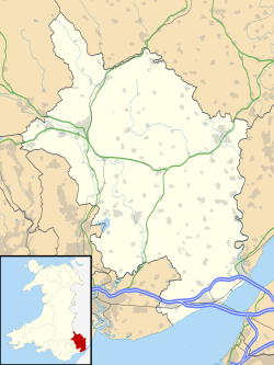
Monmouthshire UK location map.svg
Red pog.svg
Penallt
Location within Monmouthshire
OS grid reference SO521091
Community
Principal area
Preserved county
Country Wales
Sovereign state United Kingdom
Post town MONMOUTH
Postcode district NP25
Dialling code 01600
Police Gwent
Fire South Wales
Ambulance Welsh
UK Parliament
List of places
UK
Wales
Monmouthshire
51°46′45″N2°41′40″W / 51.77907°N 2.69458°W / 51.77907; -2.69458

Penallt (also spelled Penalt) [1] is a village in Monmouthshire, Wales, situated high on a hill 4 kilometres (2+12 mi) south of Monmouth. In the centre of the village, by the village green, stands the 17th-century village pub, the Bush Inn. [2]
Contents

Description

Nearby, Penallt Old Church Wood is a 10-acre (40,000 m2) nature reserve managed by the Gwent Wildlife Trust. This deciduous woodland provides a habitat for several bird species, including pied flycatchers, nuthatches, tree pipits, treecreeperss and sparrowhawks. Plant species found in the reserve include wild daffodils and moschatel.

Penallt Old Church is located approximately a mile north of the village. The main part of the building dates from the 15th or early 16th century, while the lower part of the tower may date from the 14th century. [3] The heavy oak door bears the date 1532. The church was restored in 1887. The churchyard cross has a base and lower shaft of 15th-century date. The church dedication is unknown, though there is a local tradition that it was St James, the patron saint of pilgrims. Inside is the royal coat of arms of Queen Anne dating from 1709.

The Argoed, a 17th-century mansion, lies to the south-east of the village. It was once owned by the father of Beatrice Webb, the British socialist, economist and reformer. Robert Plant of Led Zeppelin owned it in the 1980s. George Bernard Shaw stayed with the Webb family and described Penallt as a "special place" Other residents of the village include Jeremy Cook, the BBC's rural affairs correspondent,[ citation needed ] and the television presenter Kate Humble. Walter Keeler is a renowned potter specialising in salt glaze pottery.

Related Research Articles

<span class="mw-page-title-main">Gamlingay</span> Human settlement in England

Gamlingay is a village and civil parish in the South Cambridgeshire district of Cambridgeshire, England about 14 miles (23 km) west southwest of the county town of Cambridge.

<span class="mw-page-title-main">Trellech</span> Human settlement in Wales

Trellech is a village and parish in Monmouthshire, south-east Wales. Located 5 miles (8 km) south of Monmouth and 4 miles (6.4 km) north-north-west of Tintern, Trellech lies on a plateau above the Wye Valley on the southern fringes of 320 acres (130 ha) of woodland in an Area of Outstanding Natural Beauty. Three Bronze Age standing stones are situated in the village, known as Harold's Stones, which overlook the historic church of St Nicholas, a Grade I listed building.

<span class="mw-page-title-main">Saltfleet</span> Coastal village in the East Lindsey district of Lincolnshire, England

Saltfleet is a coastal village in the East Lindsey district of Lincolnshire, England. It is approximately 8 miles (13 km) north of Mablethorpe and 11 miles (18 km) east of Louth.

<span class="mw-page-title-main">Radnage</span> Village in Buckinghamshire, England

Radnage is a village and civil parish in the Buckinghamshire district of Buckinghamshire, England. It is in the Chiltern Hills about two miles north east of Stokenchurch and six miles WNW of High Wycombe.

<span class="mw-page-title-main">St Erth</span> Human settlement in England

St Erth is a civil parish and village in Cornwall, England, United Kingdom.

<span class="mw-page-title-main">Chiddingstone</span> Tudor village in Kent, England

Chiddingstone is a village and civil parish in the Sevenoaks District of Kent, England. The parish is located on the River Eden between Tonbridge and Edenbridge. The villages of Chiddingstone Causeway and Bough Beech and the hamlet Chiddingstone Hoath are also included in the parish.

<span class="mw-page-title-main">Purton</span> Village in England

Purton is a large village and civil parish in north Wiltshire, England, about 4 miles (6 km) northwest of the centre of Swindon. The parish includes the village of Purton Stoke and the hamlets of Bentham, Hayes Knoll, Purton Common, Restrop, The Fox and Widham.

<span class="mw-page-title-main">Greetham, Rutland</span> Human settlement in England

Greetham is a village and civil parish in the county of Rutland in the East Midlands of England.

<span class="mw-page-title-main">Babcary</span> Human settlement in England

Babcary is a village and civil parish in Somerset, England, about 5 miles (8.0 km) east of Somerton and 6 miles (9.7 km) southwest of Castle Cary. The village has a population of 248. It lies close to the River Cary and the A37. The parish includes the hamlet of Foddington.

<span class="mw-page-title-main">Magor, Monmouthshire</span> Human settlement in Wales

Magor is a large village in Monmouthshire, south east Wales, about 9 miles (14 km) west of Chepstow and about 9 miles (14 km) east of Newport. It lies on the Caldicot Levels beside the Severn Estuary, and is in the community of Magor with Undy. Magor lies close to the M4 motorway.

<span class="mw-page-title-main">Braceby</span> Small English village in the South Kesteven district of Lincolnshire

Braceby is a village in the civil parish of Braceby and Sapperton, in the South Kesteven district of Lincolnshire, England. The village includes a roadside nature reserve sheltering 250 species of plant life.

<span class="mw-page-title-main">West Pennard</span> Human settlement in England

West Pennard is a village and civil parish east of Glastonbury, situated at the foot of Pennard Hill, in Somerset, England. The parish includes the hamlets of Coxbridge and Woodlands.

<span class="mw-page-title-main">Bretforton</span> Human settlement in England

Bretforton is a rural village in Worcestershire, England, 4.4 miles (7.1 km) east of Evesham, in the Vale of Evesham. It is the largest farming village near Evesham. At the 2001 census, Bretforton had a population of 1,023 in 428 households. The area of the parish is 2.83 square miles.

<span class="mw-page-title-main">Catcott</span> Human settlement in England

Catcott is a rural village and civil parish, situated close to Edington 7 miles (11.3 km) to the east of Bridgwater on the Somerset Levels to the north of the Polden Hills in Somerset, England.

Gwent Wildlife Trust (GWT) is a wildlife trust covering the area between the lower Wye and Rhymney rivers which forms the vice county of Monmouthshire in south-east Wales. It is a registered charity and a member of the Wildlife Trusts Partnership.

<span class="mw-page-title-main">Newbourne</span> Human settlement in England

Newbourne is a village and civil parish in the East Suffolk district of Suffolk, England. It lies on the peninsula between the River Orwell and the River Deben, to the east of Ipswich and south of Woodbridge.

<span class="mw-page-title-main">Probert</span> Historic site in Trellech, Monmouthshire

Probert is a patronymic name derived from the Welsh "ap Robert" meaning "son of Robert", the name Robert having become common in the Welsh Kingdom of Gwent following the Norman Conquest.

<span class="mw-page-title-main">Penallt Old Church</span> Church in Monmouthshire, Wales

Penallt Old Church is located just outside the village of Penallt, Monmouthshire, Wales. It is a Grade I listed building as of 19 November 1953.

<span class="mw-page-title-main">The Argoed, Penallt</span> House in Penallt, Monmouthshire

The Argoed, Penallt, Monmouthshire, Wales, is a Victorian country house dating from the 1860s, with earlier origins from the late 16th and early 17th centuries. It is a Grade II* listed building and the garden is listed on the Cadw/ICOMOS Register of Parks and Gardens of Special Historic Interest in Wales. The English meaning of the Welsh word argoed is 'by a wood'.

<span class="mw-page-title-main">Cylch-y-Garn</span> Community in Anglesey, Wales

Cylch-y-Garn is a community in Anglesey, Wales, located on the north west coast of the county, 9.0 miles (14.5 km) west of Amlwch, 12.5 miles (20.1 km) north east of Holyhead and 15.0 miles (24.1 km) north west of Llangefni. It includes the villages of Llanfair-yng-Nghornwy, Llanrhyddlad and Rhydwyn, plus Llanrhwydrys, Caerau and Cemlyn. the north west tip of the island at Carmel Head, and the offshore islands of the Skerries and West Mouse. At the 2001 census the community had a population of 675, increasing to 758 at the 2011 census.

References

  1. "Penallt Village Website". Penallt. Retrieved 10 July 2019.
  2. "The Bush at Penallt" . Retrieved 6 October 2021. formerly the Inn at Penallt
  3. Penallt Old Church, at British Listed Buildings